Chronology Maps
Click a section name to see full details and a map.
| Completed | Route | Name | Start | End |
|---|---|---|---|---|
| M1 (NI) | Ballynacor - Birches | J11 Ballynacor | J12 Birches | |
| M8 | Renfrew Bypass | J26 Hillington | J29A Southbar | |
| M8 | Glasgow Inner Ring Road: Townhead and Woodside 1 | J15 Townhead | J16 Dobbie’s Loan | |
| M74 | Hamilton Bypass Stage II (North) | J4 Maryville | J5 Raith | |
| M1 | Tinsley - Tankersley | J34 Tinsley | J36 Birdwell | |
| M74 | Hamilton Bypass Stage II (South) | J5 Raith | J6 Hamilton | |
| M9 | Polmont and Falkirk Bypass | J4 Lathallan | Longdyke | |
| M1 | Tankersley - Dodworth | J36 Birdwell | J37 Dodworth | |
| M1 | Dodworth - Ossett | J37 Dodworth | J40 Flushdyke | |
| M6 | Penrith Bypass | Hackthorpe | J41 Catterlen | |
| M6 | Wednesbury - Darlaston | J9 Wednesbury | J10 Bentley |
What's new
Signs and sensibility
The one great attempt to make London’s streets logical - and how one retired chauffeur’s favourite routes changed the way you get around the capital.
A bridge under troubled bridges
A bridge that was ruined by another bridge, and a type of highway planning beyond any of the UK’s worst nightmares.
The monster seen from below
What might it have been like to stand in one spot and witness the arrival, and the uncertainty, of plans for an urban motorway in West London?
Have you seen...
Thelwall Viaduct
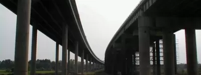
Thousands of vehicles travel the M6 between the M56 and M62 each day. They all cross the River Mersey and the Manchester Ship Canal, and the bridge that carries them is notorious from travel reports nationwide. But what does it actually look like from the ground?
