Chronology Maps
Click a section name to see full details and a map.
| Completed | Route | Name | Start | End |
|---|---|---|---|---|
| M1 | Lutterworth - Markfield | J20 Misterton | J22 Markfield | |
| M6 | Preston - Lancaster | J32 Broughton | J33 Hampson Green | |
| M4 | Chiswick - Langley | Great West Road | J5 Langley | |
| A66(M) | Blackwell Spur | A1(M) J57 Blackwell Spur | Blackwell | |
| A1(M) | Darlington Bypass | J56 Barton | J59 Aycliffe | |
| M5 | Quinton - Lydiate Ash | J3 Quinton | J4 Lydiate Ash | |
| M8 | Harthill Bypass Extension | Shotts | J5 Shotts Interchange | |
| M1 | Markfield - Kegworth | J22 Markfield | J24 Kegworth | |
| M1 (NI) | Sprucefield - Moira | J7 Sprucefield | J9 Moira |
What's new
The road that made no sense
It was the UK's only single-carriageway motorway, and twenty years ago it ceased to exist. This is the story of the strange fascination it held, and of my place in history.
The forever bottleneck, part 2
The second part of the story, where we learn why exactly the M4 gets narrower on the final approach to Europe’s biggest city.
The forever bottleneck, part 1
The M4 into London was one of the UK's earliest and most ambitious motorway projects. It was bold, pioneering... and almost instantly regretted.
Have you seen...
Thelwall Viaduct
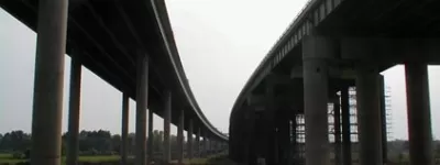
Thousands of vehicles travel the M6 between the M56 and M62 each day. They all cross the River Mersey and the Manchester Ship Canal, and the bridge that carries them is notorious from travel reports nationwide. But what does it actually look like from the ground?