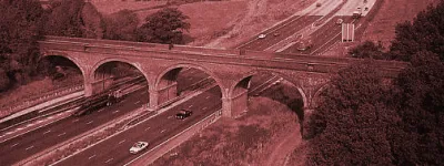
A12 (Northern Ireland)

Two miles of dual carriageway in central Belfast somehow manage to form the most important link in Northern Ireland's road network.

Belfast doesn't have much of an outer ring road and, as a result, anyone heading in to the city, out of the city, around the city or who wishes to get from any location on one side to any location on the other, will need to use the A12 Westlink.

This little bit of urban highway forms the entirety of the A12 in Northern Ireland and links the M1, M2 and M3. It is built on land reserved for a proposed inner ring motorway, but it was finally completed in the early 1980s to a much lower standard with several roundabouts and traffic signals. Its upgrade and widening, to form what is effectively an urban motorway, was finished in early 2009.

The Westlink is home to something commonplace in other parts of the world, but unique in the UK: a Single Point Urban Interchange, or SPUI. Divis Street Interchange was built in the 1980s as a conventional diamond junction, but received an upgrade that would be familiar in the US, Canada and parts of Europe but is so far largely unknown here: right turns are offset across the central bridge, meaning the whole junction can run extremely efficiently with just a few signal stages.

The one remaining snag is the York Street interchange at its northern end, which remains a flat signalised junction underneath the M2 and M3. Plans are afoot to improve this, and while the initial plan would have left at least one set of traffic signals on the Westlink, the Northern Ireland Roads Service is now hinting that it may have found a way to make the whole interchange free-flowing between the motorways and the A12.

When this is done, who knows: in as pioneering and optimistic a place as Northern Ireland the A12 might even turn blue and become a motorway itself. Stranger things have happened.

Start

York Street

End

Broadway

Passes

Belfast

Length

2 miles

Exit list

Symbols and conventions are explained in the key to exit lists. You can click any junction to see its full details.

Junction   Northbound               Southbound  
M2 J1A Docks (S) Vehicle Ferry
York Street
The NORTH
Docks (N) Vehicle Ferry
Larne
International Airport
M2 Link
City Airport
Bangor (A2)
Lagan Bridge
M3 Link


A2

M2

A2
NORTH


M3

A2
N/A
LanesLanesLanesLanes SignsSigns LanesLanesLanesLanes Signs
0.3 miles, 2 lanes 0.3 miles, 2 lanes
City Centre
(Clifton Street)
Glengormley
A6
A6 A6 City Centre
(Clifton Street)
Glengormley
A6
LanesLanesLanesLanes LanesLanesLanesLanes
0.5 miles, 2 lanes 0.5 miles, 2 lanes
City Centre
(Divis Street)
A501
A501 A501 City Centre
(Divis Street)
A501
LanesLanesLanesLanesLanes LanesLanesLanesLanesLanes
0.3 miles, 3 lanes  
City Centre
(Grosvenor Road)
B38
B38 B38
LanesLanesLanesLanesLanes
0.4 miles, 3 lanes  
Local access Bus
LanesLanesLanesLanesLanes
0.5 miles, 3 lanes 1.2 miles, 3 lanes
M1 J1 N/A
M1
SOUTH
City Centre
Europa Bus Station
Boucher Road
Falls
Royal Victoria Hospital
The SOUTH
Lisburn
M1 Link
LanesLanesLanesLanesLanes SignsSigns LanesLanesLanesLanesLanes SignsSigns
Routes

Picture credits

With thanks to Wesley Johnston for information on this page.

In this section

What's new

Schrödinger’s speed limit

In 2022, Manchester City Council say they reduced the speed limit on the Mancunian Way to 30mph. But it’s not clear if they did. It’s not even clear if they can.

Sorry, wrong number

Road numbering is a system with clear rules. What happens when the people responsible for numbering roads don't follow them?

We need to talk about Wisley

National Highways are spending a third of a billion pounds rebuilding one of the most congested junctions on the M25. Is it money well spent?

Share this page

Have you seen...

Exhibition Road

The UK's biggest "shared space" is a phenomenally expensive experiment in West London. How does it work?

About this page

Published

Last updated