For the full detail on the UK motorway and expressway network, you can’t beat the exit lists in our Motorway Database. This page will help you get the most out of them.
Our Motorway Database exit lists have been a popular feature of the website for about two decades now. They show the whole of a motorway or expressway as a single straight line, with the layouts of all the junctions, number of lanes on the road, speed limits, destinations on road signs and distances between places all marked.
There’s a lot of information in a very small space, so to help make sense of it, this page will guide you through them step by step.
On any exit list, you can click on a junction diagram or on the red “information” symbol alongside it to open a full page about that location. There’s more about that at the end of the page.
- The map
- Sign panels
- Between places
- Markerposts and junction numbers
- Opening up more detail
- Updates and corrections
The map
The map is the main feature of the exit list. It’s a simplified drawing of the layout of the road and its junctions, presented as a straight line.

Different categories of road are colour-coded using the traditional UK conventions.
| Motorways are blue | |
| Primary A-roads are green | |
| Non-primary A-roads are red | |
| B-roads are yellow | |
| Unclassified roads are grey |
On the map you’ll see a single line for a single carriageway. Dual carriageways are represented by parallel lines close together.
  |
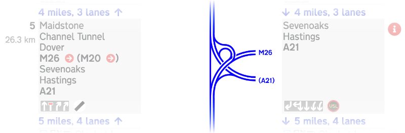
Here’s a typical two-bridge roundabout interchange, with a primary A-road dual carriageway on the left and a B-road on the right. |
 |
Here’s a junction between two motorways. |
|
|
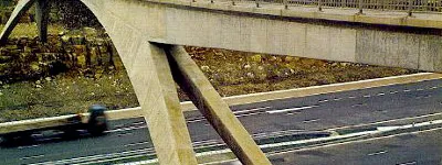
You'll see other features marked too. Here's an A-road tunnel underneath a watercourse, and a motorway service area. |


The map is designed to show you how intersecting roads connect with the motorway or expressway you’re following - how each sliproad joins and leaves, and how to find your way on or off.
The layout of every junction is accurate, but the map pays no attention to whether roads go over or under each other in real life. On Motorway Database strip maps, the motorway is always at the bottom so you can see the junction more clearly.
In some places the layout has been drawn quite differently to the topography of the real junction, often where a twisty layout has been straightened to fit our ruler-straight map, or where things are very tight and they’ve been spaced out for clarity.
If you’re using a desktop computer, you can hover your mouse pointer over a junction to see its name.

Sign panels
On the left and right of the map you’ll see grey sign panels. They list the places and road numbers shown on road signs for each junction - which might be quite different in different directions.

Signs on the left are visible to traffic travelling up the left side of the map, while signs on the right are visible to traffic travelling down the right hand side. Where you see an arrow in a red circle next to a road number, you can click it to jump to the Motorway Database page for that road. In Wales, Welsh-language text appears in italics.
If there is no exit in one direction, there’ll be no sign there.
For locations that aren’t junctions, the sign panel will tell you what is there - the name of a river crossing, for example, or a service area.

Lane symbols
Below the sign text you’ll usually see a row of symbols. These tell you what else you can expect to find at that location.
The arrangement of lanes is shown with white arrows on a grey background. They will tell you where all the lanes go when they reach the junction, and they will show any new lanes that join the motorway, but for simplicity they don’t show ordinary entrance sliproads.
| Here there are three lanes on the motorway, and you can exit from the left hand lane. There might be an entrance sliproad merging back into the left hand lane after the junction, but it won’t be shown. | |
| Here the right hand lane ends and just two lanes carry on. | |
| And this shows a new left hand lane opening up. |
There are special symbols for lanes that exit the motorway at a junction, depending on whether it comes back again afterwards.
| This type of arrow tells you that the left hand lane exits the motorway here and doesn’t come back. That means there are four lanes before the junction and only three after it. | |
| This angled arrow tells you the left lane exits the motorway, but is regained afterwards, so there are four lanes before the junction, three through it, and four again afterwards. | |
| And here there's no exit at all, but a new lane joins from a sliproad on the left. |
In some places the hard shoulder can be opened up as a part-time traffic lane by electronic signs - this is called Hard Shoulder Running. These part-time lanes are shown with pale ghost arrows.
| This junction normally has three lanes on the approach, and an exit on the left, but if the hard shoulder is open then there are four lanes and an exit on the left. |
Lane arrangements are shown in a more detailed way if you click through to the full page of information for each location - more on this is below.
Signs
Next to the lane symbols you might also see road signs like these.
| Change of speed limit | |
| Start of National Speed Limit | |
| Variable Speed Limits (VSL) apply | |
| Start and end of motorway regulations | |
| Traffic signals on the mainline of the motorway or expressway |
Between places
Between each location, on the left and right, you’ll see a line of blue text. These lines also include arrows to show which direction they apply to.

The text is self-explanatory: it tells you the distance between one place and the next, and how many lanes are on the road between those points.
If the hard shoulder can be opened up as an additional part-time lane, then the number of lanes will be followed by “HSR”, short for Hard Shoulder Running.

Markerposts and junction numbers
On the left of the map you’ll see a column that shows large black numbers and small grey numbers. Some exit lists have both, some have only one and a few have neither.
The black numbers are simply junction numbers, which appear on signs and other maps.

The grey numbers are markerpost locations. Most major roads in the UK have roadside marker posts at 100 metre intervals, to make it possible to pinpoint a specific location. The grey numbers shown on the exit list give the closest markerpost number to the centre of each junction.
Markerpost numbers are the same ones you’ll also see on blue Driver Location Signs on English motorways.
Opening up more detail
To see the full detail for a junction or other location, you can click the junction diagram or the red “information” symbol to the right of the map. You’ll then see a full page of information.
At the top is a map of the junction, taken from Openstreetmap. You can move around and zoom this map to get a better view.
Below it are links to see the same place on SABRE Maps (where you can switch between dozens of historical mapping layers and alternative map types), or on Google Maps.
You’ll then see the full information about the junction set out more clearly - listing its junction number, markerpost location and name, along with more details that aren’t visible on the exit list, like the highway authority responsible for it and more information about any service or rest area present.

At the bottom, there’s an extract from the exit list showing just that location and its signage, and finally, a written explanation of the lane and sign information, making plain exactly what each lane does at this junction and what each symbol means.
Updates and corrections
We do our best to keep the exit lists fully up to date, and try to reflect changes to the network as they happen. But we don’t always spot everything. If you see something that’s no longer correct, no matter how small, please let us know.