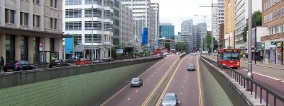
A13, A1203 and A1261

Heading east from London? Visiting the Docklands, Lakeside shopping centre or Southend Pier? Take Billy Bragg's advice, then, and hitch a ride on the A13 (and its westward pretenders, A1203 and A1261). But please don't confuse it. The poor thing is pretty muddled up as it is.

If you ever have to go to Shoeburyness
Take the A-road, the OK-road, that's the best
Go motoring on the A13

If you're looking for a thrill that's new
Take in Ford's, Dartford Tunnel and the river too
Go motoring on the A13

A13 Trunk Road to the Sea by Billy Bragg

There are nearly 30 miles of high-standard, mostly grade-separated and largely three-lane dual carriageway on the A13 route. But it hasn't the first idea what to do with them. A third of that distance is restricted to 40mph or less, for example. At its western end, the A13 peels off and completes the run into central London along congested urban streets, while the high-spec road continues parallel as the A1261 and then A1203, for no readily discernable reason. Despite the latter two being primary routes and by far the fastest way to The City, traffic is signposted off at every opportunity and encouraged to use the tedious old A13. The whole thing just makes no sense.

Half of the road is, truth be told, an embarassment to its managing authority. In 2000, Transport for London took control of all trunk roads within Greater London. Among them was the first 15 miles of A13 - but it came with a newly-let PFI contract whereby a private company was upgrading the road to a very high standard, contrary to TfL's traffic restraint policies. Unable to cancel the contract, TfL had to let the widening and grade-separation work go ahead. It's said that the tedious 30 and 40mph limits on their stretch of the road are an attempt to impose some of their thinking on what is effectively a brand new urban motorway. 40mph on a three-lane carriageway, downhill, without any frontage access, is slow enough to have anyone chewing on the steering wheel with frustration.

On the bright side, the gentle pace of the road gives the motorist ample opportunities to enjoy the incredible engineering on the way: the lengthy viaduct above the marshes near Dagenham; the elderly four-lane flyover at Ripple Road; and the Limehouse Link Tunnel. The latter is notable as being a road tunnel with a grade-separated junction inside it, and was the most expensive road ever built in the UK. Sadly it's the end of the line - it stops at a set of traffic lights. But then that's very much in character for this road.

You're not looking at the whole A13, A1203 and A1261

This page is about the parts of the A13, A1203 and A1261 that are designated a motorway or that have motorway characteristics. Other sections of this road will not be featured here and will not count towards the length of the road as shown below.

Start

Limehouse

End

Sadler's Farm

Passes

Blackwall Tunnel, Dagenham, Dartford Crossing, Tilbury, Basildon

Connects to
Length

29 miles

Exit list

Symbols and conventions are explained in the key to exit lists. You can click any junction to see its full details.

Junction   Westbound               Eastbound  
Tower Hill
Wapping
A1203
Limehouse
The City
Rotherhithe Tunnel
(A13)
WEST
A1203


(A13)
N/A
LanesLanesLanesLanes SignsSigns LanesLanesLanesLanes Signs
1 mile, 2 lanes 0.5 miles, 2 lanes
A1206

A1206
A1206 Isle of Dogs
A1206
LanesLanesLanesLanes
  0.5 miles, 2 lanes
A1261 becomes A1203
The City (A13)
Mile End (A1205)
A1261
A1261
(A13)
(A1205)


A1203 becomes A1261
LanesLanesLanesLanesLanes Signs LanesLanesLanesLanesLanes Signs
0.2 miles, 3 lanes 0.2 miles, 3 lanes
Canary Wharf
Billingsgate Market
LanesLanesLanesLanesLanes Signs LanesLanesLanesLanesLanes Signs
0.5 miles, 3 lanes 0.5 miles, 3 lanes
Isle of Dogs
Canary Wharf
A1206
A1206 A1206
(A102)
Blackwall Tunnel (A102)
Isle of Dogs
Canary Wharf
A1206
LanesLanesLanesLanesLanes
LanesLanesLanesLanesLanesLanes
LanesLanesLanesLanesLanes
LanesLanesLanesLanesLanesLanes
0.5 miles, 4 lanes 0.5 miles, 4 lanes
A1020

A1020
(A13)
City Airport
Royal Docks
A1020
LanesLanesLanesLanesLanesLanes Signs LanesLanesLanesLanesLanesLanes Signs
0.5 miles, 2 lanes 0.5 miles, 2 lanes
A13 becomes A1261
Blackwall Tunnel (A102)
The City A13

A13
(A102)

B164
A1261 becomes A13
LanesLanesLanesLanesLanes LanesLanesLanesLanesLanes
1.5 miles, 3 lanes  
City Airport
Royal Docks
A1011 (A1020)
West Ham A1011
East Ham A124
A1011
(A1020)


A1011

A124


LanesLanesLanesLanesLanesLanesLanes
LanesLanesLanesLanesLanes Signs
LanesLanesLanesLanesLanesLanesLanes
LanesLanesLanesLanesLanes Signs
0.5 miles, 3 lanes 0.5 miles, 3 lanes
Forty Acre Lane
LanesLanesLanesLanesLanes LanesLanesLanesLanesLanesLanes
0.5 miles, 3 lanes 0.5 miles, 4 lanes
Local traffic only Local traffic only
LanesLanesLanesLanesLanes LanesLanesLanesLanesLanesLanes
0.5 miles, 3 lanes 0.5 miles, 3 lanes
Plaistow
Stratford
Royal Docks
A112
A112


A112


Plaistow
Stratford
Royal Docks
A112
LanesLanesLanesLanesLanes LanesLanesLanesLanesLanes
1 mile, 3 lanes 0.5 miles, 3 lanes
Local traffic only
LanesLanesLanesLanesLanes
  0.5 miles, 3 lanes
East Ham
Beckton
A117
A117 A117 East Ham
Beckton
A117
LanesLanesLanesLanesLanesLanes LanesLanesLanesLanesLanesLanes
1 mile, 4 lanes 1 mile, 4 lanes
North Circular Road
Barking
Stansted Airport (M11 Link)
A406 Link
City Airport
Woolwich Ferry
A1020
A1020 A406
(M11)
North Circular Road
Barking
Stansted Airport (M11 Link)
A406 Link
City Airport
Woolwich Ferry
A1020
LanesLanesLanesLanesLanesLanes
LanesLanesLanesLanesLanes
LanesLanesLanesLanesLanesLanes
LanesLanesLanesLanesLanes
0.5 miles, 3 lanes  
River or canal River Roding River or canal River Roding
  0.5 miles, 3 lanes
Local traffic only Local traffic only
LanesLanesLanesLanesLanes LanesLanesLanesLanesLanes
0.4 miles, 3 lanes 0.2 miles, 3 lanes
Local traffic only
LanesLanesLanesLanesLanes
  0.2 miles, 3 lanes
Creekmouth
River Road Ind. Est.
Creekmouth
River Road Ind. Est.
LanesLanesLanesLanesLanes Signs LanesLanesLanesLanesLanes Signs
0.6 miles, 3 lanes  
Local traffic only
LanesLanesLanesLanesLanes
0.1 miles, 3 lanes 0.7 miles, 3 lanes
Barking
A123
Becontree
A1153
A123

A1153
Barking
A123
Becontree
A1153
LanesLanesLanesLanesLanes LanesLanesLanesLanesLanes
0.4 miles, 3 lanes 0.4 miles, 3 lanes
Renwick Ind. Est.
LanesLanesLanesLanesLanes SignsSigns Signs
0.2 miles, 3 lanes  
Becontree
Gale Street
LanesLanesLanesLanesLanes
  0.6 miles, 3 lanes
Dagenham
Hornchurch
A1306
Dagenham Dock
A1306 Dagenham
Hornchurch
A1306
Dagenham Dock
LanesLanesLanesLanesLanes LanesLanesLanesLanesLanes
1 mile, 3 lanes 1 mile, 3 lanes
Signs Signs
0.5 miles, 3 lanes 0.5 miles, 3 lanes
Dagenham (E) (A1306)
Hornchurch
Elm Park (A126)
A1311
(A1306)
(A126)
Dagenham (E)
Hornchurch
LanesLanesLanesLanesLanesLanes LanesLanesLanesLanesLanesLanes
1 mile, 4 lanes 1 mile, 4 lanes
Rainham
(B1335)
Ferry Lane Ind. Est.
(B1335) Rainham
(B1335)
Ferry Lane Ind. Est.
LanesLanesLanesLanesLanesLanes LanesLanesLanesLanesLanesLanes
2 miles, 3 lanes 2 miles, 3 lanes
Rainham
Aveley
Purfleet
A1306
A1306 A1306 Rainham
Aveley
Purfleet
A1306
LanesLanesLanesLanesLanes Signs LanesLanesLanesLanesLanes Signs
2 miles, 3 lanes 2 miles, 3 lanes
M25 J30 The NORTH (M1 Link)
Stansted Airport (M11 Link)
Chelmsford (A12 Link)
M25 Link
Dartford Crossing
Channel Tunnel (M20 Link)
Gatwick Airport (M23 Link)
A282 Link
A1090
A282
A1090
M25 The NORTH (M1 Link)
Stansted Airport (M11 Link)
Chelmsford (A12 Link)
M25 Link
Dartford Crossing
Channel Tunnel (M20 Link)
Gatwick Airport (M23 Link)
A282 Link
LanesLanesLanesLanesLanesLanes LanesLanesLanesLanesLanesLanes
1 mile, 4 lanes 1 mile, 4 lanes
A126 West Thurrock
Lakeside Shopping Cen.
Grays
A126
LanesLanesLanesLanesLanesLanes LanesLanesLanesLanesLanesLanes
1 mile, 3 lanes 1 mile, 3 lanes
West Thurrock
Lakeside Shopping Cen.
Grays
A1202
South Ockenden
Orsett
A1202 South Ockenden
Orsett
LanesLanesLanesLanesLanes Signs LanesLanesLanesLanesLanes Signs
2 miles, 3 lanes 2 miles, 3 lanes
Tilbury
A1089

A1089
Tilbury
A1089
LanesLanesLanesLanesLanes LanesLanesLanesLanesLanes
1.5 miles, 3 lanes 1.5 miles, 3 lanes
Brentwood
A128
Stanford-le-Hope
Grays
A1013
A1013

A1013
A128 Brentwood
A128
Stanford-le-Hope
Grays
A1013
LanesLanesLanesLanesLanes LanesLanesLanesLanesLanes
2 miles, 3 lanes 2 miles, 3 lanes
Shell Haven
Coryton
A1014
Laindon
B1007
A1013

A1014
B1007 Shell Haven
Coryton
A1014
Laindon
B1007
LanesLanesLanesLanesLanes LanesLanesLanesLanesLanes
3 miles, 2 lanes 3 miles, 2 lanes
Basildon A176
Vange
Corringham
B1420
B1240


A176

B1464
Basildon A176
Vange
Corringham
B1420
LanesLanesLanesLanes LanesLanesLanesLanes
2 miles, 2 lanes 2 miles, 2 lanes
Pitsea (B1464)
Basildon
A132
A132

(B1464)
Pitsea (B1464)
Basildon
A132
LanesLanesLanesLanes LanesLanesLanesLanes
1.5 miles, 2 lanes 1.5 miles, 2 lanes
N/A A130

A13


A130 (A127)
EAST
B1464


Canvey Island A130
South Benfleet A13
Bowers Gifford B1464
Chelmsford A130
Southend Airport (A127)
LanesLanesLanesLanes LanesLanesLanesLanes
Routes

Picture credits

With thanks to Sunil Prasannan for information on this page.

In this section

What's new

Schrödinger’s speed limit

In 2022, Manchester City Council say they reduced the speed limit on the Mancunian Way to 30mph. But it’s not clear if they did. It’s not even clear if they can.

Sorry, wrong number

Road numbering is a system with clear rules. What happens when the people responsible for numbering roads don't follow them?

We need to talk about Wisley

National Highways are spending a third of a billion pounds rebuilding one of the most congested junctions on the M25. Is it money well spent?

Share this page

Have you seen...

Abbreviations

How do you describe a road? One way is to use these engineering abbreviations, much loved by the UK's community of road enthusiasts.

About this page

Published

Last updated