M12 (Northern Ireland)

The M12 is Northern Ireland's weirdest motorway, with its flat roundabout and its unexpected collapse to a single carriageway road part-way through its terminal junction.

The M12 was originally meant to be an urban motorway serving the new town of Craigavon, starting on the M1 and burrowing into the town. It would have formed a C-shape as it passed through the urban area. When the M1 was built, the first section of M12 was built along with it, a short spur towards Craigavon to provide basic access to the motorway, and nothing was ever done to finish it. Indeed, the whole of Craigavon is basically half-built and has never reached anything like its intended population.

Because it was always meant to go much further the end of the M12 feels decidedly unfinished. Travelling out of Craigavon, motorway restrictions begin halfway underneath junction 2, where the road widens out to dual carriageway. Technically, non-motorway traffic can use the road until this point, from which there is no exit.

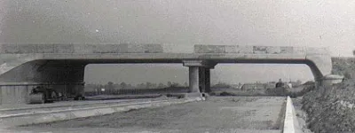
Junction 1 was originally envisaged to be a three-level interchange. In the 1960s it was opened with east-facing slips only, and a bridge was built over the M1 ready for its completion. In 1992, the junction was finished, but without actually bothering to build a third bridge to complete the interchange - instead using a flat roundabout to connect the three arms. It does look ridiculous, but it's functionally no different from a roundabout interchange - these kick off a number of mainland motorways like the M50 and M180.

Thanks to its mid-way roundabout, its strange narrowing to single-carriageway and its decidedly unfinished nature, the M12 might be one of the strangest and least motorway-like motorways anywhere in the UK.

Start

North Craigavon

End

Craigavon

Passes

None

Connects to
Length

1 mile

Click a section name to see its full details, or click a map symbol on the right to see all motorways opened in that year.

Completed Name Start End
Craigavon Spur M1 J11 Ballynacor J2 Carn Chronology map for 1967
Western sliproads to M1 M1 (NI) J11 Ballynacor J1 Ballynacor Chronology map for 1991

Exit list

Symbols and conventions are explained in the key to exit lists. You can click any junction to see its full details.

Junction   Northbound               Southbound  
1 Dungannon
Cookstown
M1 Link
Belfast
Lisburn
M1 Link


M1
NORTH


M1
N/A
LanesLanesLanesLanes LanesLanesLanesLanes
1 mile, 2 lanes 1 mile, 2 lanes
2 N/A B2


(A3)
SOUTH
B2


Carn
Seagoe
B2
Craigavon Centre
Portadown
Armagh
(A3)
LanesLanesLanes Signs LanesLanesLanesLanes Signs
Routes

Picture credits

With thanks to Wesley Johnston for information on this page.

In this section

What's new

London’s other forgotten motorways

We’ve spent years documenting the unbuilt urban motorway network planned for London. Today we’re unveiling more new routes that have never been seen before!

The middle of nowhere

A national system of road numbers radiating from a central point suggests there is… well, a central point. But if you go looking for it you’ll find it doesn’t exist.

Not so Smart

There have been rumours for months. Now the announcement has been made - “all new Smart Motorways scrapped”. What does this mean and who are the winners?

Share this page

Have you seen...

Road signs

A field guide to the UK's road signs, explaining the colours, shapes, symbols and everything else you need to know to avoid putting a foot (or a wheel) wrong.

About this page

Published

Last updated