In 1959, Britain had never seen anything like it. Six lanes wide and grade separated for almost sixty miles, the M1 was a sign of things to come for a country still working its way out of the aftermath of the Second World War.
The photographs on this page showing the M1 as it was built appear courtesy of David Jones, who cycled out to the site as a schoolboy to take them. They have never been published before. They are not presented in date order, instead moving from early stages of construction to completion. In reality different structures and sections of road were finished at different times.
The contractors for most of the M1's length were Laing. These are their headquarters on site at Newport Pagnell, taken 28 May 1958.
Laing numbered each of the bridges along the route to keep track of them all. This is one of the large cranes used on site, seen near bridge 74. 30 May 1958.
No road surface has been laid yet near what is now Milton Keynes. This is the approach to junction 14 as it appeared on 9 May 1959.
Bridges 69 and 70, now forming part of junction 15, are only just started. Reinforcing mesh has been set up for the bridge deck. These bridges were demolished a few years ago when J15 was redeveloped. 30 May 1958.
Bridge 115 under construction, with the road diverted temporarily around the outside. Note the contractor's sign on the left — "London — Yorkshire Motorway/Laing/Bridge no. 115". Believe it or not, this road is the A45. 31 October 1958.
Bridge 50 nearing completion — this one is a small footbridge. The bridge deck looks a little thin but will be strengthened with the addition of the concrete parapet. 9 May 1959.
Bridge 55a, a small underpass, is finished and the path underneath seems to have been surfaced at the same time. 17 August 1959.
Bridge 55, confusingly, crosses the River Ouse. This shows some detail of the marvellous sculpted concrete bridge. 17 August 1959.
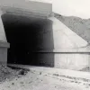
Detail of a railway underpass at bridge 51. This railway did not survive the Beeching cuts. 9 May 1959.
Bridge 78, at what is now junction 15a, allows the canal to pass underneath complete with a new lock.
Bridge 74 is a box-shaped metal structure carrying the railway south from Northampton, still in use today. 18 August 1959.
Detail of the underside of the same bridge, taken from the nearly-finished road bed. 18 August 1959.
Looking north from bridge 79, north of what is now junction 15a, at the virtually complete motorway. One line of road markings are still to be painted. 18 August 1959.
An anonymous contributor adds the following information:
"You might find the following interesting — it's a community history project website produced by a local school and contains a potted history of a section of the (old) A5, prior to the Milton Keynes Dual Carriageway section, which ran through what was the village of Loughton.
"We have lots of flyovers around Milton Keynes but the one referred to on this page was, as it says, constructed before MK was thought of and was apparently a prototype for M1 construction. M1 J14 is 3 miles away."
Picture credits
- All photographs on this page appear courtesy of David Jones.
With thanks to Mark Wilson for information on this page.


