A grand south western approach road would reach from London to Richmond, Basingstoke and Southampton. But the A316 was entangled in local politics, and the M3 was never to enter London at all.
A story that is played out on these pages, time and again, is about big plans for better roads that fell apart because they had to be built through the places people lived. It turns out that it's difficult to build new roads in London.
It's even more difficult to build new roads in Richmond. A pleasant and historic town set on a particularly handsome loop of the Thames, Richmond's residents were kicking up a stink about changes to the A316 before the rest of London had even noticed that motorway plans were afoot.

Opposition was stiff even in the 1920s, when the Great Chertsey Road was first pushed through the northern edges of Richmond and Twickenham. It only intensified after the Second World War when plans were formed to substantially upgrade it and connect it to the national motorway network.
What's left today is a road you can drive in its entirety, if you wish, and from the countryside to Twickenham you'll find a road the Ringway planners would have recognised. From there to its terminus in Chiswick, though, is a compromise adorned with makeshift fixes and unrealised ideas.
Outline itinerary
A4 (Hogarth Roundabout)
R2 Western Section
River Thames (Chiswick Bridge)
A205 Mortlake Road (Chalker's Corner)
B353 Manor Road (Manor Circus)
A307 Kew Road (Richmond Circus)
River Thames
A3004 St Margaret's Road (St Margaret's Roundabout)
Egerton Road
B358 Hospital Bridge Road (Hospital Bridge Roundabout)
A312 Hampton Road (Hope and Anchor Interchange)
A314 Hounslow Road (Brown Bear Interchange)
Nailhead Road
A308 Staines Road (Sunbury Cross Interchange)
R3 Western Section and Southern Section (Sunbury Interchange)
R4 Western Section and South Orbital Road (Thorpe Interchange)
Continues to Bagshot and Basingstoke
Cost summary
| Property acquisition (1970) | £5,700,000 |
| Rehousing (1970) | £700,000 |
| Construction (1970) | £10,750,000 |
| Total cost at 1970 prices | £16,450,000 |
| Estimated equivalent at 2014 prices Based on RPI and property price inflation | £242,926,036 |
See the full costs of all Ringways schemes on the Cost Estimates page.
Route description
This description begins at the southwestern end of the route and travels northeast.
Thorpe to Twickenham
Entering London from the south west, the M3 exists today as planned in the 1960s, a major motorway from Southampton and Basingstoke. It would meet Ringway 4's South Orbital Road and Western Section at Thorpe Interchange, today's M25 junction 12.
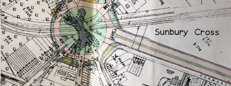
Passing Thorpe and Shepperton, the motorway would curve through the semi-urban landscape of golf courses and lakes to arrive at Sunbury Common, where a free-flowing interchange would connect with Ringway 3's Southern Section and Western Section. The junction would provide access to and from the country, but would have no access to or from London. Immediately to the east, the motorway would terminate at Sunbury Cross, today's M3 junction 1, which would have London-facing sliproads only.
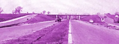
From here, the route would continue as the A316 Country Way, a dual three-lane road built in the early 1970s by the Greater London Council (GLC) as an inward continuation of the M3. This road exists and can be driven today, running on a lengthy elevated viaduct over the water treatment works at Kempton Park.
Grade-separated junctions would connect to local roads around Hanworth and the A312 Hampton Road. Beyond here, the A316 becomes the Great Chertsey Road, one of the grand arterial roads built in London between the wars - though it never reached Chertsey. Country Way and the M3 were built several decades later to meet that aim.
Today, the Great Chertsey Road is a jumble of styles and widths between here and the road's terminus at Chiswick, but in the 1960s the GLC's intention was to improve the road onwards in to London to match the standard of Country Way. A wide three-lane dual carriageway would have carried traffic through Whitton and Twickenham, with flyovers and underpasses replacing the present roundabouts. In part this would pass through what is now open ground on the south side of the road, but in the 1960s was occupied by temporary pre-fab housing.
Twickenham to Chiswick
Passing north of Twickenham town centre, the A316 Great Chertsey Road would cross the Thames at Twickenham Bridge, with the structure expanded or replaced to accommodate a much wider road. There would be no junction at Richmond Circus, and parallel local roads would provide connections to the town centre instead.
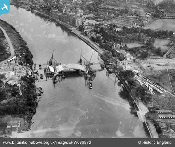
Interchanges would follow at Manor Circus, where the present-day B353 Manor Road would take on the role of an eastern bypass of Richmond town centre, and at Chalker's Corner for the A205 Mortlake Road. The road would then cross the Thames again at Chiswick Bridge, where widening or a new bridge would be required.
The road would meet the Ringway 2 Western Section at the bridge over the Hounslow Loop railway line. A free-flowing junction on four levels would provide turns in most directions between the two roads, with some sliproads passing below the tracks and some over the top.
Beyond here, the A316 would only be widened to provide two lanes in each direction. An upgrade to the existing Burlington Lane would smooth out the corners slightly, speeding traffic through to the Hogarth Roundabout, where the road would terminate on the A4.
M3 or not M3
The early sixties were an extraordinarily optimistic time for road planners. New long-distance motorways were planned in all directions from the capital, and most of them were supposed to hammer their way right in to the centre. The M1 was, at one stage, supposed to reach Marble Arch, and there was vague talk of the M4 extending all the way to Kensington.
The M3 was different. South west London had a ready-made alternative to urban motorway building in the shape of the Great Chertsey Road. Built between the wars, it had been intended to open up new land towards Chertsey and relieve Richmond Bridge, but it never carried much traffic, and petered out somewhere near Feltham. Back in the 1930s locals nicknamed it the "road to nowhere". Its main purpose since then had been to give residents of Twickenham a quicker route to central London.
When the 1960s arrived, with proposals for the M3, Middlesex County Council already had plans to extend the Great Chertsey Road to Sunbury Cross. All planners had to do was plug their new motorway in to it for an oven-ready road to Central London. For that reason, the M3 was always going to come to an early stop at Sunbury, where it ends today.
Some occasional mentions survive in planning documents referring to the M3 reaching Chiswick - but all are attributable either to over-excited assumptions, or to their author having too little interest or too little space to make the distinction between M3 and A316. There is no evidence to suggest the motorway would ever have reached further into London than it does now.
Jumping the Kew
By 1964, plans for the M3 were well advanced, and it was known to people living nearby that the Great Chertsey Road would become a new main approach to London.
The hot topic in Richmond and Twickenham's local press at this time was about how locals would lose access to the A316 when it became the much-discussed "M3 Feeder". Surrey County Council, which covered Richmond-upon-Thames until the formation of the GLC, proposed to make room for all that displaced local traffic by demolishing large areas of the town centre to build a new dual carriageway. It would cross The Green to reach Richmond's 18th century stone bridge, now a Grade I Listed monument, which would be demolished and replaced with something bigger.
That plan was not very popular, for a whole host of reasons that will be immediately obvious, and it was also expensive for what it would achieve. Its price tag of £4.2m was comparable with the cost of the M4 between Chiswick and Heston, opened in September of that year. A return to the drawing board was in order.
On 1 January 1965, Surrey County Council and Richmond Council jointly announced a new plan, one that would cater for local traffic without destroying the town centre or the historic bridge. It's this plan that offers a rare glimpse of what might have been envisaged for the A316.
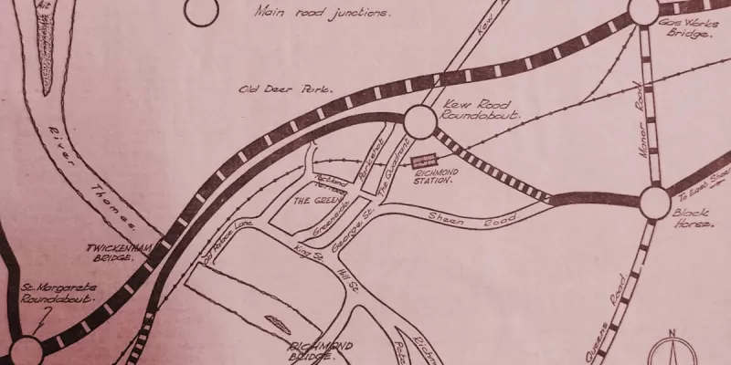
The Great Chertsey Road, in its new guise as the "M3 Feeder", would run on its present line around the west and north of Richmond. Interchanges would be provided at the A309 Hospital Bridge Road, Egerton Road (an innocuous residential street that would be obliterated to form a new main approach to Twickenham), the A3004 St Margaret's Road, and then a long run straight past Richmond and Kew to the B353 Manor Road, which would lead to an eastern bypass of the town centre via the Richmond Hill Tunnel.
Running "alongside or below" the A316 between St Margaret's Road and Manor Road would be a new local route. That wording suggests the design for the A316 was still uncertain, but there was at least the possibility that it would run at the upper level of a double-deck structure, like the M4 at Brentford, with a dual carriageway underneath providing connections to the town and other streets.
As well as saving Richmond town centre, the new proposal would also save over £1m compared to the cost of the old plan. The scheme was Surrey's gift to the new London Borough of Richmond-upon-Thames, which was inaugurated on 1 April 1965 as Richmond moved from Surrey to newly-created Greater London. It became one of the few new Boroughs to arrive with a fully formed plan for its roads on the day the GLC unveiled its London-wide motorway network.
Strike it Richmond
If Surrey County Council were hoping for hearty thanks from the brand new Borough, as it inherited the 1965 plans for either a double deck road or a four parallel carriageways hurtling through Richmond Circus, they were disappointed. The new council took a dim view of it. For one thing, the political make-up of the new authority was less predisposed to road building; for another, the new council had members from Twickenham, which had never been consulted.
Such was its discomfort with London's ever-expanding highway plans that, in 1969, the council asked a firm of consulting engineers to make a critical study of new road plans within its boundaries.
The report produced by Frederick Snow and Partners in 1970 was every bit as disparaging of the GLC's highway plans as the council that had commissioned it. The conclusion - and Richmond-upon-Thames' position, forcefully argued over the following years - was that a primary road serving Richmond was a good idea, but that there was no need for it to be anywhere nearby. Not only did they not support widening or upgrading the A316, but they also - remarkably - said:
"Provided that access to the primary road system is possible by the A.316 there is no benefit to the Borough of having any part of the primary road system (other than the A.316) within it."
Richmond's official position was, in other words, that they were a NIMBY Borough. New roads? Yes please. But not in our patch. They can go in other Boroughs, and affect other people, and we'll cross the boundary when we want to use them.
Nothing new under the Sunbury
In 1973, with the M3 a year away from opening, agitation about the new motorway continued to grow. A "mass influx" of traffic was feared on opening day, but the A316 connecting to its terminus at Sunbury wouldn't be finished for another year.
The Great Chertsey Road had always been intended to reach Chertsey, of course, but by the outbreak of the Second World War, it had only progressed as far as the Hope and Anchor pub where it met the A305 west of Twickenham. Further extensions were then delayed until Middlesex County Council dusted off the plans in the late 1950s. Their proposals were to build the next phase of the road, dualling the A305 from the Hope and Anchor to Sunbury Cross.
Soon enough, though, the Ministry of Transport unveiled its plans for the M3, which would take over the line of the planned Great Chertsey Road from Sunbury Cross onwards, leading out into the countryside towards Basingstoke. The new motorway caused traffic forecasts for the A305 to climb and climb, so that by 1963 Middlesex had to redraw all its designs for the upgraded A305 to provide three lanes each way and flyovers at all the junctions.
In fact, the designs were redrawn again and again, and then in 1965 the old County Council was abolished and replaced with the GLC, who continued to revise the project. Spades only hit the ground in the early 1970s, by which time the M3 was under construction. The new road between the Hope and Anchor and Sunbury Cross would now be the A316 Country Way, a partly elevated dual three-lane road with grade separated junctions throughout, but it wouldn't open until 1974.
In the meantime, fearful local residents lobbied to have the new M3 restricted somehow, and the transport minister, John Peyton, agreed to "throttle" the motorway until the A316 was ready for use. Motorists trying out the new road in its first year would have found the M3 painted down to a single traffic lane before it hit the terminus at Sunbury Cross, and onward from there, several miles of roadworks.
The GLC also wanted to improve the existing road through Twickenham, Richmond and Chiswick. But stiff opposition from both local residents and the Borough Council meant that it was in no hurry. In 1971, they reported to the panel of the GLDP Inquiry that they expected the next improvement in that area to be Ringway 3's Western Section, joining the M3 at Sunbury; following that would be Ringway 3's Southern Section; and then some time in the 1980s Ringway 2's Western Section would open, meeting the A316 at Chiswick. Only then would it be worthwhile improving the A316 to provide three continuous lanes and flyovers or underpasses from Twickenham to the Hogarth Roundabout.
In the meantime, the work they had in mind was minimal. In the same year, a firm of consultants were engaged to plan "minor" improvements to the Great Chertsey Road, with the aim of adding 20% extra capacity. Unveiled in 1973, the £2.1m scheme included no flyovers, no underpasses and no property demolition. Instead the GLC closed some minor side roads, added turning lanes at junctions and investigated the construction of subways.
The modest plans were unveiled by Toby Jessel, Conservative MP and GLC member for Twickenham (his diary must have been full). Deriding the plans, the Labour candidate for his GLC seat said the money "was hardly enough to clean up the road", let alone improve it, but in fairness - given the discontent on all sides - it's hard to see that much more was realistically possible.
In the end, even less was achieved. Unable to widen the road or to improve its junctions, the main hope had been for pedestrian subways, but those proved too expensive and too disruptive. Running out of time to do something before the M3 opened, the GLC instead built a series of temporary footbridges to provide pedestrians with a way to cross the speeding stream of traffic. They are actually Bailey Bridges, a trusted design developed for temporary bridges erected by the army during the Second World War.
If the idea of a rickety bridge over the A316 feels familiar, it probably is. Now approaching half a century old, all four temporary Meccano-style footbridges are still there today, a reminder that on the road network, "temporary" installations usually become permanent.
When the epic public inquiry into the Greater London Development Plan was completed, the Layfield Report recommended substantial changes to the M3 and A316 route. Instead of running up to the A4 at the Hogarth Roundabout, a new road would carry it south of the river to meet the A3 at Wandsworth. Layfield also scrapped Ringway 2 so there would be no motorway through Barnes or Chiswick in his plan. But the final outcome of 1973's political and planning upheaval was that all plans to improve the A316 or the roads around Richmond were cancelled - a change that really only formalised the stalemate that had been reached eight years before.
Sources
- Interchange at R2: ACC/3499/EH/08/04/020.
- Two lanes R2-A4: HLG 159/399; GLC/TD/PM/CDO/07/097.
- Surrey CC plan for Richmond: "Two-lane main road may not be needed now", Richmond and Twickenham Times, 21 March 1964.
- Second plan for Richmond, 1965: "£3m. road is planned", Richmond, Twickenham and Barnes Herald, 1 January 1965; also "£3m road plan approved", Richmond, Twickenham and Barnes Herald, 22 January 1965.
- Richmond commissions report from Frederick Snow and Partners: GLC/DG/AE/ROL/02/188, GLC/DG/AE/ROL/02/189.
- M3 capacity throttled on opening: "Minister agrees to reduce lanes to M-way extension", Middlesex Chronicle, 13 July 1973.
- GLC ultimate aims for A316, improvements to follow opening of R2: HLG 159/2323.
- GLC improvement scheme and temporary footbridges: Keltz, J. "GLC plans to spend £2 million on Chertsey Road", Roehampton Herald, 8 February 1973.
- Layfield proposal for new route linking A316 to Wandsworth: HLG 159/626.
Picture credits
- Route map contains OS data © Crown copyright and database rights (2017) used under the terms of the Open Government Licence.
- Aerial photo of Chiswick Bridge under construction is courtesy Britain From Above, EPW036970. © Historic England. Used under the "blogging use" licence terms.
- Photograph of A316 near Hanworth is taken from an original by N Chadwick and used under this Creative Commons licence.
- Photograph of A316 near Richmond Circus is taken from an original by Stephen McKay and used under this Creative Commons licence.
- 1960 plan for Sunbury Cross is extracted from MT 106/128.
- Photograph of Richmond Bridge is taken from an original by Jim Osley and used under this Creative Commons licence.
- Plan of 1965 Surrey County Council scheme for Richmond is taken from Richmond and Twickenham Times, 1 January 1965.
- Photograph of Welcome to Richmond sign is taken from an original by Michael Dibb and used under this Creative Commons licence.
- Photograph of Country Way viaduct is taken from an original by Christine Johnstone and used under this Creative Commons licence.


