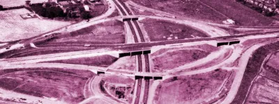
Ringway 1 would have been one of the largest inner ring roads the world had ever seen: an urban motorway encircling about sixty square miles of central London, including the whole of the City, Westminster and all of the present-day Congestion Charging zone, plus almost all of its docklands and the East End.
Otherwise known as the London Motorway Box, this was not the smooth circular shape that the word "ring" in its name would suggest. Forcing its way through densely built-up areas, it followed railway lines to limit its intrusion on the neighbourhoods it passed through. The places in which it was possible to build thus dictated the shape of the motorway; a squashed box of a ring road thundering through the slums. Its proximity to the central area made it easily the most intrusive and difficult of all the proposed roads in the Greater London Development Plan.
Each side of the box was, in many respects, a route in itself, and each was often discussed by the Greater London Council in relative isolation. The project was thus split into four obvious components, dubbed the North, South, East and West Cross Route. These terms appear to be derived from the London County Council's 1950s-era terminology for major roads in central London that carried through traffic — there was a South West Cross Route and a North-South Cross Route, for example. The motorway plans drawn up by the LCC, and expanded by their successors at the Greater London Council, were new, purpose-built replacements for this network of streets, and so they were given names as part of the same scheme.
Ringway 1 was easily the most important of the road proposals of this era: it was the LCC's only ring road and the only urban ring road retained after the Layfield Inquiry. Perhaps remarkably, in the hefty book of evidence that the GLC submitted to justify its road plans, the Council's engineers did not insert even a single passage outlining the case for the road as they did for all their other proposals. Maybe they thought its purpose was so obvious that there was no need.
It was to be an inner ring road that would rescue the ancient streets of central London from the tyranny of traffic congestion. It was to be designed to allow speeds of 50mph throughout, and even in the heaviest rush hours some thirty years after it opened, the GLC's planners intended that traffic speeds would never drop below 35mph.
The price that the GLC were willing to pay for the route reflects their high regard for it. The 1969 estimate for the cost of the route was more than £1bn, in an era when Government spending rarely mentioned "billions" at all, such was the rarity of anything that would cost so much. Land costs made up the largest part of that sum. In today's prices the equivalent would be £12.86bn, though in fact a calculation based on property price and construction inflation only tells half the story. It would now be astronomically more since many of the places Ringway 1 was to pass through were deprived in 1966 but are now much sought-after places to live.
Compensation to evictees would also be an enormous cost: it was estimated in May 1968 that some 36,000 people would have to be rehomed to make way for the road. 13,300 of those would be on the North Cross Route; 2,650 on the East, 3,200 on the West and 16,850 on the South Cross Route.
No surprise, then, that central Government (the Ministry of Transport included) was very keen to distance itself from these controversial plans. Ringway 1 alone — a relatively small part of the total mileage of the Ringway plans — would have been the most expensive scheme of public works ever undertaken in this country, and the Treasury in particular was very anxious to see the Motorway Box put to an early death.
Surprisingly, a substantial amount of it was built. The entire eastern flank is there to be driven today, and a short section in the west was opened to traffic, though in recent years has been substantially altered and is no longer recognisably a motorway. Ringway 1 is long dead and these fragments will never be linked up into a circuit now, but on road signs, traffic reports and street maps, they still carry their motorway names: West Cross Route and East Cross Route.
The following pages describe the route clockwise from the north-western corner.
Sources
- Motorway followed railway lines to "limit intrusion" on neighbourhoods: HLG 159/1024 discusses planning of the network, including use of existing severance (such as railways) to reduce impact on urban area.
- "Cross Route" terminology: Map and list taken from Report of the Committee on London Roads, July 1959.
- Ringway 1 as "minimum solution": GLC stated that "the urban Motorway Box and the links to the radial motorways converging on London will be minimum requirements", GLC Minutes of Proceedings, 6 April 1965, pp. 347-53; referenced in Motorways In London ed. J Michael Thomson p. 106.
- No justification of R1 in GLC submission to GLDP inquiry: HLG 159/1024 outlines the purpose of each road proposal in turn, except R1.
- Design speed and service levels: HLG 159/626.
Picture credits
- Artist's impressions of West Cross Route above Kensal Green Cemetary is from "New Roads in West and North Central London", GLC, 1965.

