This page is about abandoned proposals to incorporate the A13 into an urban motorway network for London. Information about the route as it exists today is in the Motorway Database.
The road to the Essex coast, serving the heavy industry of the Thames Estuary and day-trippers to Southend. It might have spawned a motorway - but nothing is certain.
Reaching out from the City of London along the north bank of the Thames to Southend-on-Sea and then Shoeburyness, the A13 is the traditional road to the seaside for much of North and East London. The popularity of the Essex resorts, the restless port traffic at Tilbury and the thriving industrial complexes of Dagenham and Thurrock all conspired to make the A13 one of London's most congested approaches by the 1960s.
Its problems were not for want of investment. In the 1920s, a whole new highway - the A127 Southend Arterial Road - had been built to provide a new, better way to the sea. In the decades that followed sections of the suburban A13 were progressively bypassed and widened to dual carriageway.
By the late 1960s, when the Ringways were being planned, it was already one of London's better roads. But it wasn't nearly good enough. A 1970 report produced by the Ministry of Transport, summarising trunk road plans in Greater London, remarked:
"In the vicinity of the Ford Motor Company's plant and neighbouring industrial areas at Dagenham extreme traffic congestion occurs because of locally generated traffic."
Planners were set to work on ways to fix the A13, bringing it up to standard with the GLC's Primary Road Network of urban motorways and unblocking its queues of lorries. The outcome of their studies has not, in the main, come to light, but glimpses of their thinking have turned up here and there.

By the early 1970s, an additional burden was upon the A13. Proposals to build London's third airport at Maplin Sands meant that the A13 was considered as a road connection to the new airport - a suggestion that called for a new motorway, M13, and an extraordinary feat of engineering at Southend.
None of those plans came to pass, which is why, by the mid-1990s, the A13 was horribly overloaded and underengineered. A series of bypasses, widening schemes and junction improvements were completed in the early 2000s, giving us the modern A13 we have today - but not one very much like the A13 envisaged in the late 1960s.
Outline itinerary
![]() Continues to Basildon and Southend
Continues to Basildon and Southend![]() Ringway 3 Eastern Section
Ringway 3 Eastern Section![]() Old A13 to Thurrock (Wennington Interchange)
Old A13 to Thurrock (Wennington Interchange)![]() Local connections to Rainham (Rainham Interchange)
Local connections to Rainham (Rainham Interchange)![]() A125 Rainham Road (Dovers Corner)
A125 Rainham Road (Dovers Corner)![]() Possible local connections to Barking and Dagenham
Possible local connections to Barking and Dagenham![]() Ringway 2 Eastern Section
Ringway 2 Eastern Section![]() A117 Woolwich Manor Way
A117 Woolwich Manor Way![]() A1011 Silvertown Way (Canning Town Interchange)
A1011 Silvertown Way (Canning Town Interchange)![]() Ringway 1 East Cross Route (Blackwall Interchange)
Ringway 1 East Cross Route (Blackwall Interchange)
Route map
Scroll this map horizontally to see the whole route

Key to map symbols
| "Primary Road" Network | |
|---|---|
| Primary Road | |
| Primary Road section in tunnel | |
| Primary Road approximate or assumed line | |
| Primary Road cancelled or deleted before start of GLDP Inquiry | |
| "Secondary Road" Network | |
| Secondary Road single carriageway or of unknown formation | |
| Secondary Road known to be dual carriageway | |
| Secondary Road section in tunnel | |
| Junctions | |
| Location of Primary Road junction where layout is not known | |
| Location of Secondary Road junction where layout is not known | |
| Location of a junction cancelled or deleted before start of GLDP Inquiry where layout is not known | |
Route description
This description begins at the western end of the route and travels east.
Blackwall to Thurrock
The A13 begins at Aldgate, on the edge of the City of London, but in the Greater London Development Plan its first section on the way out of London would only be part of the Secondary Road Network. The starting point of the A13 as a Primary Road would be where it met Ringway 1's East Cross Route at Poplar.
The junction that exists today on that site was supposed to be temporary. Plans for a permanent junction were produced in 1972, but presumably derailed by the Greater London Development Plan Inquiry. In its final form, a three-level stacked roundabout interchange would have connected Ringway 1 to the A13, with links to the A1206 towards Millwall.
Striking out east, the A13 would be improved on its existing line, so the route can be easily traced today. Policy set out in 1970 was to provide dual three-lane carriageways throughout, with grade separation "at major junctions", though some property accesses and side roads would remain. That's very similar to the modern A13, but the present road was improved in the late 1990s and early 2000s, and was not built to plans produced in the Ringways era.

A roundabout interchange, opened in the early 1970s, would connect to the A1011 Silvertown Way at the present Canning Town Flyover, but after that point a 1965 GLC planning map shows no other junctions until the road reaches the A117 Woolwich Manor Way. It would seem odd to have no junction at the A112, midway between the two.
A large free-flowing interchange would provide access to Ringway 2's Eastern Section at Beckton. Designs for this junction were produced in 1969, but none have yet come to light.
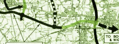
After crossing the River Roding, immediately east of the present-day junction with the A406 North Circular, the A13 would branch off its current alignment to the south. This bypass was called the A13 Relief Road. It would run east through what was then open land, on the line of modern-day Thames Road.
Continuing south-east, it would curve around the south side of Barking Reach power station and through the Ford motor plant, turning north-east again after crossing the Beam River to re-join the old A13 near Cherry Tree Lane. An A13 bypass on a completely different line was built in the 1990s to carry out much the same role, so from here the route follows what is now the A1306.

An interchange with the A125 Rainham Road would be followed by an upgrade to New Road, the Rainham Bypass, an inter-war improvement on a line suitable to be turned into a rural dual carriageway. Plans were produced for this scheme in 1972 by the Department of the Environment, but the GLC disputed them, producing an alternative design for the section through Rainham that would have placed the new A13 in a short cut-and-cover tunnel to reduce its impact on the town.
Beyond Rainham, the A13 reaches the GLC boundary, and would have branched off to the east along what is now the Aveley Bypass, running slightly north of the present A13 towards Tilbury. On the way, the route would intersect Ringway 3 near Thurrock, and then continue east towards Basildon and Southend.
Barking up the wrong tree
As a trunk road, the A13 was the responsibility of the Ministry of Transport. The settled policy, by 1970, was to progressively widen and upgrade the existing A13 to provide three lanes in each direction and flyovers or underpasses at all its major junctions.
That policy is straightforward and entirely believable, but also decidedly unambitious. Ideas to fix the A13 just a few years previously were far more dramatic.

Consulting engineers Freeman, Fox and Partners had been engaged in the early 1960s for the "London-Tilbury Improvement Study", tasked with devising a programme of improvements for the A13. They concluded, in 1965, that motorway standards were required, full hard shoulders should be provided wherever possible, and that traffic demand for much of the route between Inner London and Rainham would be so great, once new housing developments were completed, that five lanes in each direction might be justified.
Upgrading the A13 to five lanes each way, adding full hard shoulders and removing all side turnings was not a likely prospect. Even putting aside the cost and horrific damage to the surrounding urban area, policy in the mid-1960s was that four-lane motorways were to be considered absolutely exceptional and that formations wider than that were not permissible.
Another solution was required, which might be where the A13 Relief Road comes in. Appearing in some planning documents and network proposals in the late 1960s, the Relief Road would have branched off the A13 near Beckton and taken a new line closer to the Thames, through what was then largely marshland and low-rent industrial yards to bypass the A13 through Barking and Dagenham.

Its purpose is clear, even if it was never stated: the Relief Road would add much-needed new capacity without the destruction of widening the existing road, and it would separate through traffic from the congestion caused by deliveries and commuters to the industrial estates.
The Relief Road doesn't figure in the Ministry's stated policy for the A13 in 1970 - though its wording doesn't actually rule out the construction of new sections to achieve that standard. It would be a complex project, crossing marshes and a thriving motor production plant, and an expensive one, and like all the most difficult tasks, the Ministry was happy to consider it a job for the distant future.
The south end of Southend
In parallel with the A13's improvement works, another idea for the very distant future was brewing.
In April 1971, while the Greater London Development Plan Inquiry was still ongoing and the Ringways were still an active proposal, the Government announced that Maplin Sands, off the Essex coast beyond Southend, had been selected as the site for London's third airport.
The project was on an unbelievable scale, calling not just for a new airport larger than Heathrow to be built at sea, but also a deep water container port, a New Town of 600,000 people near Rayleigh, a four-track high speed railway line and a motorway connection to London. Maplin's planners examined many possible routes for the combined road and railway link, and preferred an extension to the M12, which would continue the motorway from its planned terminus at Brentwood across Essex to reach Maplin.

So great was the projected demand for travel to Maplin, though, that the Maplin Development Authority realised that one motorway might not be enough. Eventually, they declared, a second full motorway link to London would be required. It would have to be in a different corridor to the first, for greater resilience and to share the load of traffic approaching Maplin from different directions. The route they chose was that of the A13.
Branching off the A13 at Rainham - exactly where the A13 Relief Road would rejoin it, in what is unlikely to be a coincidence - the "A13/M13" route travels northeast towards Upminster before striking out east. Multiple route options are then possible, some joining the line of the M12, and all eventually ending up at Maplin Sands again.
Maplin Airport is not really within the scope of these pages, and indeed the M12 page doesn't go into detail on the Maplin-era plans for the M12's extension. The M13 is equally peripheral to this page - but one thing about it makes it absolutely irresistible, and that is the line of Route F1, the option that seems to have been among the most likely.
It's the route that carries the M13 south of Southend.

A huge tidal barrage, some ten miles in length, would take the motorway offshore near Canvey Island and run about a mile from the shore right along Southend seafront. It would pass through Southend Pier and curve around Shoebury Ness. Within it, the beach at Southend would be on a calm tidal lagoon, and families paddling in the gentle breakers would look out at the rush of motorway traffic on the horizon.
The engineering consultants even suggested that the space between the M13 and the coast could be reclaimed as land, though it seems highly unlikely that a decision would ever have been taken to maroon a seaside resort a mile inland. But the barrage plan was real, and there's even evidence of opposition groups being formed in Southend and Leigh-on-Sea to oppose it.
In 1974, amid a change of Government, Maplin was cancelled. It was too ambitious and too expensive. With it went the M13, and Southend's tidal barrage, and one of the most bizarre and ambitious motorway plans ever to be created.
Sources
- Quote from 1970 MOT report; policy for three lanes and grade separation: MT 120/252.
- Current A13 result of 1990s and 2000s improvements: "Major New £200M Road Project to Regenerate East London and Docklands", AMEC (2000), held by the Internet Archive, 16/10/06.
- Route, R1-R2 and Tilbury-GLC boundary: GLC/TD/C/P/02.
- Route, R2-Tilbury; A13 Relief Road: MT 106/453.
- Interchange with R2 at Beckton; London-Tilbury Improvement Study; requirement for five lanes: MT 106/279.
- Maplin Sands selected as third airport; co-location with container port and New Town; cancellation 1974: Hall, Peter (1982). Great Planning Disasters. University of California Press. "On Tour: The Maplin Story", Business Travel News, 23/01/12.
- Two motorway links and four-track high speed railway; selection of route F1 as preferred alignment; route, Tilbury-Southend-Maplin: AT 56/98.
Picture credits
- Route map contains OS data © Crown copyright and database rights (2017) used under the terms of the Open Government Licence.
- Plans of R1/A13 interchange and GLC tunnel scheme at Rainham are extracted from GLC/TD/PM/CDO/07.
- Aerial photograph of congestion on A13 is extracted from MT 106/147.
- Photograph of A13 at Prince Regent is taken from an original by Chris Whippet and used under this Creative Commons licence.
- Aerial photograph of East Ham and Barking Bypass © 2020 Google.
- Plan showing A13 Relief Road is extracted from MT 106/453.
- Plan showing route F1 is extracted from AT 56/98.