Today it's one of London's most complete radial routes, but the road envisioned by planners in the 1960s would have been even bigger: perhaps a motorway, perhaps double-deck, or perhaps not.
Described below is the route of the A40 Western Avenue as it would have looked if it had been incorporated into the Greater London Council's Primary Road Network, better known to us as the Ringways. It would, without a doubt, have been one of London's busiest and most important approaches. But it's important to establish at the outset that this does not include the single most visible surviving manifestation of the GLC's motorway programme.
The A40(M) Westway, an elevated motorway built in the late 1960s by the GLC to connect Western Avenue with Central London, became a byword for the inhuman extravagance of the capital's motorway ambitions from the day it opened, and maintains that reputation and notoriety to this day. It's often used as an example of the sort of roads that would have ringed and bound the metropolis, had the GLC got its way. But it doesn't feature on this page, because it wasn't part of the Primary Road Network and it wasn't one of the Ringways.
The GLC considered the Westway a Secondary Road, and it is narrower and poorer in design than almost all their planned rings and radial routes. The A40 as a Primary Road would have started at Denham on the M40, and terminated on Ringway 1 at Shepherd's Bush. That is the route described here.
What's set out below, then, is the history of Western Avenue, the flagship project of the inter-war Arterial Roads Programme, and the interminable quest to cater for the seemingly bottomless demand for journeys between London, Uxbridge, Oxford and beyond.
Outline itinerary
Continues to High Wycombe and Oxford
R4 Western Section and R3 Denham Spur (Denham Interchange)
B467 Park Road (Swakeleys Roundabout)
A437 Long Lane (Hillingdon Circus)
R3 Western Section
A4180 West End Road
A312 Church Road (Target Roundabout)
A4127 Greenford Road (Greenford Roundabout)
B456 Argyle Road (Perivale Junction)
R2 North Circular Road (Hanger Lane Interchange)
Link to R1 North Cross Route
A4000 Victoria Road (Park Royal Interchange)
B408 Old Oak Road (Gypsy Corner)
A219 Wood Lane (Wood Lane Interchange)
R1 West Cross Route
Local connections to Paddington (Paddington Slip)
Continues as A501 Marylebone Road
Cost summary
| Property acquisition (1970) | £3,000,000 |
| Construction (1970) | £29,025,000 |
| Total cost at 1970 prices | £32,025,000 |
| Estimated equivalent at 2014 prices Based on RPI and property price inflation |
£127,856,158 |
See the full costs of all Ringways schemes on the Cost Estimates page.
Route description
This description begins at the western end of the route and travels east.
Denham to Acton
Approaching London from Oxfordshire, the M40 passes south of Beaconsfield to arrive at Denham, a major interchange where a tangle of interlinked sliproads would connect to the Ringway 4 Western Section, the Denham Spur towards Ringway 3's Western Section, the A40, A412 and A4020. Only part of this junction exists today, which is the Denham Roundabout at M40 junction 1. At least one plan exists showing the A40 east of Denham as A40(M), implying motorway status, but this doesn't appear to have ever been seriously considered.
East-facing sliproads would connect to the B467 Swakeleys Road, before a roundabout interchange at Hillingdon Circus with the A437 Long Lane. The northern bypass of this junction was built in the early 1990s and is not a Ringways-era design. Sliproads would link through to a major interchange to the east, where the Ringway 3 Western Section would cross the A40. Local junctions would follow at the A4180 Ruislip Road and A312 Church Road, similar to those present today.
Further improvements would follow, with the A40 on its present line, including the flyover at the A4127 Greenford Road, completed in the 1960s. The junction with the B452 Argyle Road is a product of the 1990s and would differ in layout to Ringway-era plans.
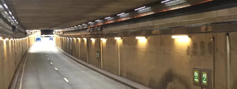
At Hanger Lane, the A40 descends into a long two-lane tunnel. The third lane would split off, as it does today, to reach a complex interchange above with the Ringway 2 North Circular Road, though designs for this junction have not yet come to light.
Acton to Shepherd's Bush
From here, further upgrades would eliminate all the remaining traffic lights on Western Avenue, though there would only be two lanes for through traffic on flyovers, with the third lane entering and exiting at each junction.
A major interchange would be built just east of Park Royal, where the A40 crosses the Central Line railway. Eastbound motorists would have the choice of staying on the A40 towards London, or branching off left onto a two-lane motorway leading to Ringway 1 at Willesden Interchange. Traffic heading for the North Cross Route and West Cross Route would leave the A40 here.
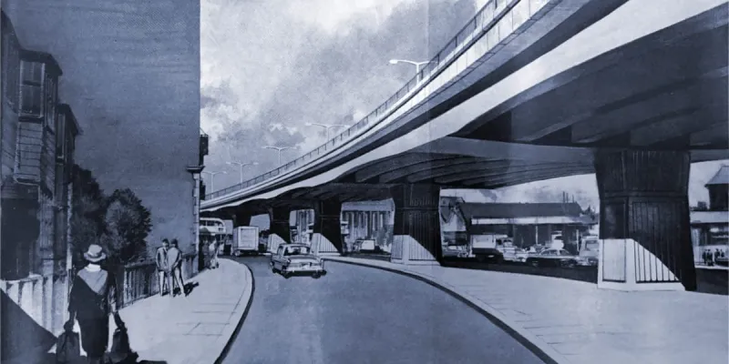
Shortly afterwards, at Gypsy Corner, the A4000 Horn Lane would pass below a new flyover, with the present one-way gyratory system removed. Three lanes would then cross the North London Line Railway before the next interchange, where sliproads would branch off and run underneath another flyover to reach a compact roundabout with Old Oak Road at Western Circus (now more commonly called Savoy Circus).
At the A219 Wood Lane, the A40(M) Westway would begin. Sliproads would lead to a three-level roundabout interchange with access to the Ringway 1 West Cross Route. The A40's journey as a major road would end here, with the Westway ahead continuing to Central London as a GLC Secondary Road.
The grandest arterial
The fact that the A40 forms such a major and effective approach to London is partly thanks to it being the product of some very early city planning. It's also partly just luck.
Many new roads built in London between the wars had their genesis in the 1914 "Arterial Road Conferences", a series of meetings where politicians and engineers met to form plans for improved highways.
Western Avenue (sometimes then referred to as "Great Western Avenue") was among their proposals. Most of those early Arterial Roads were built in open land, serving London's outer suburbs, and shying away from the demolition that would have been needed to get in any closer. This was the only one to reach any distance towards the centre, and that was mainly good fortune.
"The open ground to the south of Wormwood Scrubbs, now temporarily occupied by exhibition buildings, comes nearer to the City than any other vacant space within the County of London, and presents an opportunity of forming a good western outlet which should on no account be lost."
The opportunity was not lost. Between 1921 and 1943, sections of new road were progressively built to link Wood Lane near Shepherd's Bush with the sleepy village of Denham in Buckinghamshire, where the new road flowed into the existing A40 towards Oxford. It was an excellent road for its time - a single three-lane carriageway, with cycle tracks, footpaths and space for expansion, admirably direct and blessed with roundabouts at all its major junctions.
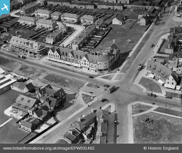
At the end of the Second World War, Western Avenue (then still the A403) was complete from Wood Lane to the countryside, but was already a victim of its own success. Ways to extend it further in to London, to avoid journeys down Wood Lane and around Shepherd's Bush Green, had been under discussion for more than a decade, but even the road that was already open needed further urgent work.
Digging deep
In the 1950s, successive projects slowly provided a dual carriageway on one section of Western Avenue after another - now, since 1951, part of the A40. These tended to provide two 30-foot carriageways, each with three relatively narrow lanes, a standard fairly typical on widened roads in London at the time.
The project worked inwards from Uxbridge, and by 1957-58 had finally reached Inner London, with construction work around Alperton and Park Royal to widen railway bridges and build the urgently required second carriageway. Indeed, such was the demand for travel on the road, even though it still stopped dead at Shepherd's Bush, that the Ministry provided something quite unusual for the 1950s: an innovative "fly-under" at Hanger Lane.
This novel structure was, of course, the dual two-lane tunnel that still carries the A40 under its junction with the North Circular Road. Grade-separation of any kind was considered quite exceptional, especially in urban areas, and the project showed every sign of inexperience from everyone involved.
The underpass contract was let in September 1958 to civil engineers AE Farr Ltd, using documents prepared by the Ministry's consulting engineers, and the project went rapidly downhill from there. Farr excavated far more earth than they were being paid for, because the contract was based only on a calculation of the volume of the underpass, and not the extra material that had to be dug out to provide working space to build walls and foundations.
Once the junction opened to traffic, the recriminations began: Farr claimed £123,000 more than the contract said they were due, and the matter eventually went all the way to the House of Lords - who thought the injustice even graver and awarded the company £171,984 plus interest.
When the dust settled, auditors found that the consultants had drawn up the contracts based on provisional figures, the Ministry had failed to check over them properly or to understand the method of work that was being requested, and Farr had dug out far more material and made an awful lot more mess than was actually required to get the thing built.
It was a catalogue of mistakes and lessons had to be learned if the grand aspirations for Western Avenue were to come to anything.
Reaching higher
A bit more dual carriageway and a dingy underpass beneath the North Circular brought Western Avenue to the dawn of the next decade, but it was already evident that ambitions of the 1950s would not match the traffic levels of the 1960s. More work was needed.
Luckily, the Ministry had just the man to provide a solution: CG Havers, an engineer with the Metropolitan Roads Division, who had prepared a report into the "comprehensive improvement" of the North Circular in 1961. His report evidently went down well, because he was drafted in to deliver a similar report about comprehensive improvement of Western Avenue in August 1962.
It was known by this time that the London County Council would be extending the road east from Wood Lane to reach Central London. They hadn't quite worked out how yet, but the eventual outcome was of course the A40(M) Westway.
Havers calculated that the arrival of the extension to the east, and the M40 to the west, would cause traffic levels to rise noticeably, beyond the general increase forecast for the road network as a whole, and that east of Greenford there would easily be demand for 6,000 vehicles per hour both ways. That would require four lanes in each direction just to cater for immediate demand, allowing no space for future growth. Reviewing the calculations, Havers wrote:
"All this is in a sense an academic exercise since within practicable limits of cost I do not think we can provide facilities everywhere on Western Avenue even for the minimum design figures stated above."
What Havers proposed was still ambitious: an elevated road, similar to the Hammersmith Flyover, which would run from Hanger Lane (the North Circular Road) to Wood Lane. It would carry two express lanes each way, while three lanes each way would remain at ground level. At least one set of crossover sliproads would be provided between the end points.
The report also recommended possible junction layouts for the whole road between Denham and Wood Lane - largely two-bridge roundabout junctions at all the major crossing points. Havers then suggested that the whole project (including an elevated road more than three miles long) should ideally be complete by 1965. He admitted that there may be "financial limitations" that would affect this superhuman goal.
A taste of the future
The scheme of comprehensive improvement, and the pace at which it had been recommended, proved impossible in reality. The demand for road improvements across London meant that the resources available to Western Avenue simply weren't enough to get it done.
Instead, the Ministry of Transport contented itself with making a series of smaller, individual improvements over time, starting with the worst bottlenecks. The flyover at the A4127 Greenford Road was one such change, and east of Hanger Lane, two more projects were then pursued. Neither matched Havers' ambition for an elevated road and a total of five lanes each way, though - the finished A40 would have been a three lane road, with just two lanes over the flyovers at Gypsy Corner and Western Circus.
Western Circus came first, with engineering consultants WV Zinn and Associates agreeing to come up with a solution in July 1964. They had not worked for the Ministry before and put in a huge amount of work, though it was possibly more than strictly necessary. Flyovers and underpasses were evaluated, different layouts of sliproads were considered, and detailed artists' impressions were drawn up for multiple different architectural styles.
The work - meant to be complete in 1965 - rumbled on, with concrete construction methods under discussion in 1967 and soil surveys in 1968. The reason the flyover was never built isn't clear; possibly it just missed the boat in the 1960s because it still wasn't ready to be built by 1973, when all London's road plans were thrown into a state of uncertainty. Later proposals in the 1980s and 90s also came to nothing.
Making much better progress was a similar flyover scheme for Gipsy Corner, the junction of the A4000 just to the west. Legal orders for this junction were published in 1966, so it was virtually ready for construction while WV Zinn and his colleagues were still sharpening their pencils. The project would have provided a dual two-lane flyover along a substantial length of road, with sliproads tucked in underneath for some distance either side of the junction, effectively a short length of double-deck road.
But despite the legal preparations being complete, no contracts were let and no work ever started at Gipsy Corner, and it was another place where plans for a flyover were still being considered in the 1990s. Today there's still a set of traffic lights at both these locations.
Given that neither scheme really matched the comprehensive improvement plan developed only a few years previously, and that plan itself was knowingly unable to meet the demand for travel forecast along the A40 in coming years, it's possible that the Ministry just wasn't very committed to projects that wouldn't meet their aim of free movement on London's roads.
Perhaps they were waiting for some bigger and better project to come along. Perhaps they thought the spur to Ringway 1 would siphon off enough traffic that their flyovers would be unnecessary. Perhaps there were just other schemes with a better claim to funding. Whatever the reasons, the result is the same: the A40 is still, today, a work in progress, and not one that will now be finished.
Sources
- Denham Interchange; single plan showing A40(M) east of Denham: MT 120/233.
- Junction layouts at Hillingdon and R3: MT 120/252.
- Park Royal interchange and spur to R1: MT 106/437.
- Gypsy Corner flyover plans: MT 106/423.
- Western Circus flyover plans: MT 118/212.
- Western Avenue planning and Arterial Road Conferences: HLG 46/74.
- 1950s era dualling and Hanger Lane underpass problems: MT 123/140.
- 1962 Comprehensive Improvement report: MT 106/193.
Picture credits
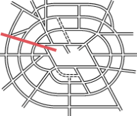
- Route map contains OS data © Crown copyright and database rights (2017) used under the terms of the Open Government Licence.
- Artist's impressions of Western Circus flyover extracted from MT 118/212.
- Plan of interchange complex at Hillingdon extracted from MT 120/252.
- Plan of Gypsy Corner flyover extracted from MT 106/423.
- Admission tickets for Arterial Roads Conferences extracted from HLG 46/74.
- Aerial photo of Western Circus in 1930 is courtesy Britain From Above, EPW031462. © Historic England. Used under the "blogging use" licence terms.
- Photograph of Hanger Lane underpass under construction is taken from an original by Ben Brooksbank and used under this Creative Commons licence.
- Photograph of interior of the Hanger Lane underpass is © FM Conway and used with permission.
- Diagrams from "comprehensive improvement" report extracted from MT 106/193.


