Opened in 1960, the Ross Motorway (sometimes known as the Ross Spur and, more commonly, the M50) was one of the UK's very first motorways.
The booklet published to commemorate its completion and opening is gloriously and unashamedly proud of this small but pleasant route, describing it as "one of the most beautiful roads in Britain".
Being so early in the 1960s motorway programme, the M50 was sometimes referred to as an experimental motorway, and this booklet describes not just the road that was built and opened, but also contains huge amounts of detail on the motorway programme in general, rules for motorway driving, the process of planning motorways, how route numbering works and even arrangements for gritting and salting it in winter.
Front cover
Page 1
Pages 2-3
Pages 4-5
Pages 6-7
Page 8
Page 9
Pages 10-11
Pages 12-13
Pages 14-15
Page 16
Page 17
Pages 18-19
Pages 20-21
Pages 22-23
Pages 24-25
Page 26
The Ross Motorway
Published for the Ministry of Transport by Her Majesty's Stationery Office, 1960
The Motorway Programme
By ancient law and custom the main roads of this country, formerly known as the King's or Queen's Highway, have until recently been open to the public without distinction or exception. On most roads the citizen retains that right; but with the opening of the first motorways a new type of road, the 'special road', designed and built for the exclusive use of certain classes of traffic, has been introduced.
Traffic counts carried out by the Ministry of Transport and the Road Research Laboratory on main roads after the Second World War showed that ten per cent of Britain's roads carried sixty per cent of the traffic. From these figures, and from further studies of the pattern of the nation's traffic, it appeared that a comparatively small mileage of really first-class road - road with dual carriageways and without cross traffic or obstructions to cause bunching - would produce very great improvements in traffic flow, and that some of these roads could most economically be built as motorways.
Tentative plans for 800 miles of motorway were included in a road-building programme prepared by the Ministry of Transport and published in 1946. Before any detailed planning could be done the programme was shelved on account of the economic difficulties through which the country was then passing.
The Special Roads Act was passed in 1949. This Act, now consolidated in the Highways Act, 1959, enables the Minister of Transport, or Local Authorities acting with his approval, to build roads for use by such classes of traffic as may be specified in the relevant schemes. For example, they could be reserved for motorists alone, or for pedestrians or pedal cyclists.
In February 1955, the Minister of Transport published the first instalment of an expanded road programme which included the London-Yorkshire Motorway, the Birmingham-Preston Motorway and, as part of a proposed new route from Birmingham to South Wales, the Ross Motorway.
Preston By-Pass, forming part of the proposed Birmingham-Preston Motorway, was started in 1956 and opened in December 1958, thus becoming the first completed length of motorway in the country.
The London-Birmingham Motorway, which forms the first section of the London-Yorkshire Motorway, was started in March 1958, and opened to tratic in November 1959. A scheme for the second part of the motorway, that between Crick and Doncaster By-pass, has been made and a draft scheme for a spur from this motorway to Sheffield and Leeds is being prepared.
By the spring of 1960, traffic on the London-Birmingham Motorway - the M.1 - was averaging nearly 16,000 vehicles a day. The full benefit of this six-lane road will not be felt until the northward extensions to Lancashire and Yorkshire are built but the saving in time to the individual driver between London and Birmingham is very noticeable. A recent study has shown that the average time saved on a journey from London to Birmingham along the M.1, compared with the same journey along the A.5 and A.45 before the motorway was opened, is 42 minutes for a car, 31 minutes for a light goods vehicle, 27 minutes for a medium goods vehicle and 21 minutes for a heavy goods vehicle.
Meanwhile, work has started on the main bridge works and on some of the road works for the Birmingham-Preston Motorway, and draft schemes have been published for linking this motorway, the London-Yorkshire motorway and the Birmingham to South Wales route.
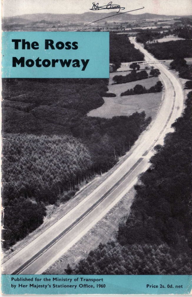
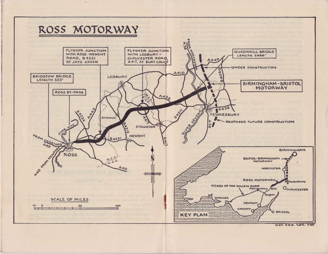
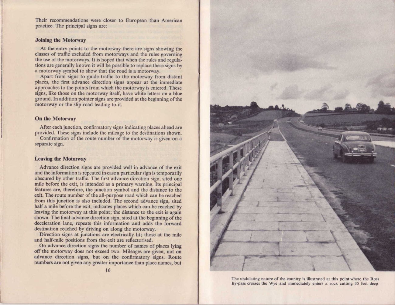
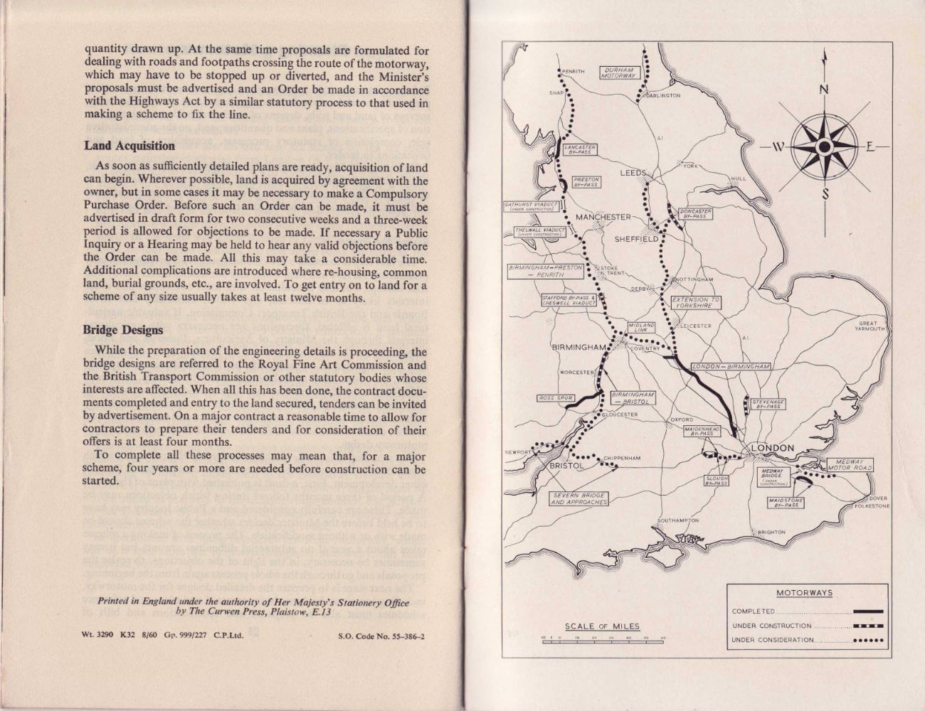
The newly completed Ross Motorway forms a spur from the line of the Birmingham-Bristol Motorway. Starting near Tewksbury it runs westwards to Ross-on-Wye. Beyond Ross the existing trunk roads to South Wales are being progressively improved as a continuation of the motorway route. One of these improvements, the Ross By-pass, carried over the River Wye on the new Bridstow Bridge, was opened in September 1960. The Birmingham-Bristol Motorway, from the southern outskirts of Birmingham to the Ross Motorway junction, is now being built. When it is completed in the autumn of 1961, there will be a continuous motorway route between Birmingham and Ross. The southern section from the Ross Motorway junction to Bristol is in the preliminary planning stage.
In July 1960, the Minister of Transport, Mr. Ernest Marples, announced that expenditure on motorways as well as on roads in congested urban areas was to be substantially increased. The Government's aim would be substantially to complete the five major projects over the next five or six years and at least to start the Yorkshire Motorway in the same period. The five major projects to which Mr. Marples referred are:
- Modernisation of the Great North Road (A.1).
- Completion of the motorway from London to Birmingham and the north-west.
- Improved route from London to the Channel Ports including the 25-mile Medway Motorway.
- The northern part of the motorway from Birmingham to Bristol, with spur to Ross and improved routes from Ross to South Wales.
- The South Wales Motorway from London to London Airport and on to Maidenhead, and at the western end the Severn Bridge and Newport By-pass.
These principal through routes will be built to the highest standards of design. By the mid 1960's, when they are completed, they will be fully adequate to meet all traffic demands for many years to come.
The Ross Motorway
A Vital Link between the Midlands and South Wales
Three of the five great motorways included in the Minister of Transport's road programme radiate from Birmingham. One stretches away to the north-west; another to London with an extension northwards to Yorkshire; and the third to the south-west.
The route to the south-west is the future M.5. Work on the northern end has already started and when completed it will provide a fast route between Bristol and Birmingham. Half way down the M.5, and within sight of historic Tewkesbury, is the Ross Motorway, or the M.50 as it will be known in future.
From one end of the Ross Motorway to the other is not more than 21 miles, with a mile and a half of all-purpose road added as a by-pass to Ross-on-Wye. A motor car travelling at 70 m.p.h. - the designed speed of the road - could cover the whole distance in twenty minutes. Why, then, was it given priority over so many other motorway projects?
The answer is that those twenty miles or so of motorway are a vital link between the Midlands and South Wales. There is no other industrial road route worthy of the name. Such roads as exist are steep, narrow and winding and totally unsuitable for heavy transport.
The need for a new road was recognised as long ago as 1946, when the first blueprint of Britain's future motorways was drawn up; and the project received strong support in 1953, when the Lloyd Committee, set up to advise the Government on ways of encouraging industrial development in South Wales, stressed the need for better roads. Hence the high priority accorded to M.50.
At Wilton in Herefordshire the Ross By-pass joins the A.40 to Raglan and here the road divides. One route leads on to Swansea, Neath and Port Talbot via the Heads of the Valleys Road; the other turns south to Newport. All these roads are being reconstructed.
M.50 is therefore destined to be a vital industrial artery, one that cannot fail to lead to greater transport efficiency and so strengthen our competitive position in overseas markets. Traffic on the motorway in 1961 is expected to average about 10,800 passenger car units a day.
This figure - which must be expected to increase with the general growth of traffic - takes no account of the many tourists who may be attracted to the motorway.
Some facts and figures about the motorway
| Started | March 1958 |
| Opened to traffic | November 1960 |
| Length of motorway | 21 miles |
| Length of modernised section of A.449 and Ross By-pass | 1½ miles |
| Total length of newly opened road | 22½ miles |
| Design speed | 70 m.p.h. |
| Maximum curvature | 2,046 ft. radius |
| Maximum gradient | 1 in 25 |
| Visibility | 800 ft. |
| Formation width | 88 ft. |
| Lay-out | Dual 24-ft. carriageways with four marginal strips 12 ins. wide |
| Central reservation | 13 ft. |
| Hard shoulders | 8 ft. wide in 11 ft. 6 ins. verges |
| Surface | Hot rolled asphalt |
| Cost (approx.) | £6,000,000 |
Beauty of Scenery and Design
"One of the most beautiful roads in Britain." That is the unanimous verdict of those who have driven along the M.50 and many would give it first place.
Much of the charm of the road lies in its design, for which great credit is due to the County Surveyors who planned the road and many of the bridges and to the Consulting Engineers who designed the principal bridges. For example, the contours of the road have been drawn so as to give a smooth streamlined effect and there is a complete absence of those visual kinks which so often occur when a long ribbon of road is viewed from the driver's seat. Note also the absence of any scars such as may be observed on roads newly-built through chalk-lands.
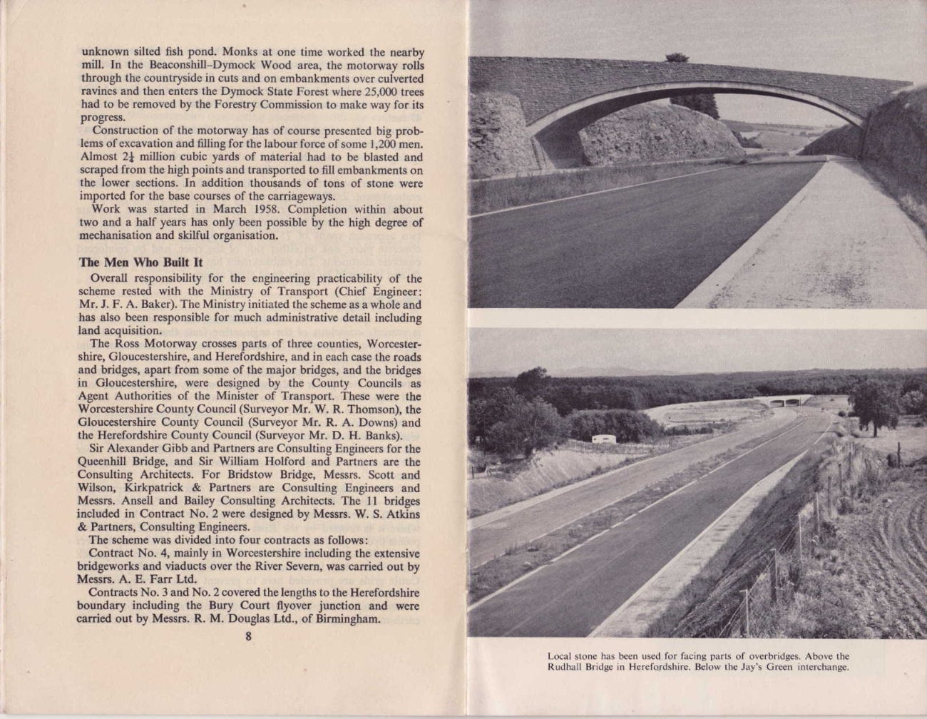
The bridges - there are 39 of them - show a pleasing variety in colour as well as in design. Cotswold stone was used to face one bridge in Worcestershire contrasting pleasantly with the red sandstone from local quarries used in Herefordshire. The concrete finish of the Queenhill Bridge over the Severn is considered quite outstanding.
Traffic Capacity
Yet this road was designed, not for the tourist, but for industry, and all the bridges, in spite of their graceful lines, are built to carry "abnormal indivisible loads" upwards of 150 tons.
The dual 24-ft. carriageways are considered adequate to meet all present and potential traffic requirements. Dual two-lane carriageways have a maximum traffic capacity of 35,000 passenger car units a day which should be ample on the Ross route.
The carriageways are of flexible construction and although the base and sub-base varies with local conditions the riding surface of hot rolled asphalt is uniform throughout.
Between the carriageways there is a 13-ft. central reservation. The hard shoulders for use in emergency are 8 ft. wide set in verges 11 ft. 6 ins. wide. They consist of a stone or gravel base, surface dressed and chipped with a contrasting stone. Marginal strips a foot wide mark the edges of the carriageways.
Two Outstanding Bridges
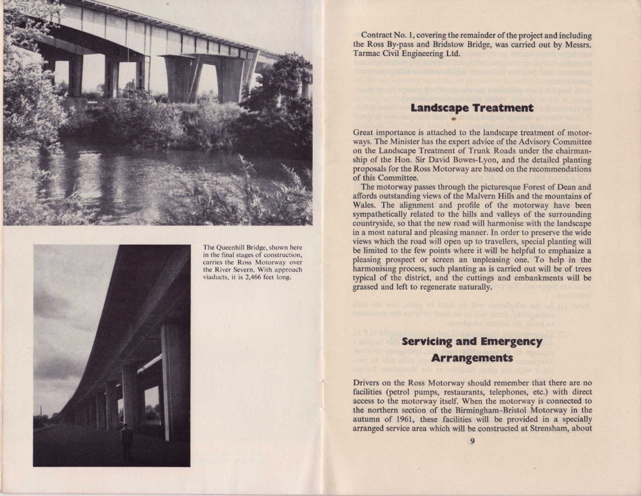
There are two major bridges, one over the Severn at Queenhill and the other over the Wye at Bridstow. The Queenhill Bridge, together with approach viaducts, is half a mile long and cost over £14 million. It is a three-span continuous steel girder bridge with a centre span of 140 ft. (headroom 44 ft.) and two side spans of 130 ft. each.
Particularly impressive, when viewed from the valley, is the sweeping curve of the structure throughout its entire length, the radius of curvature being about 8,000 ft. The bridge is of dual construction. That is to say it is built in two separate parallel halves, each half carrying one of the dual carriageways. Twin anchor piers of reinforced concrete, splayed as they rise to deck level, are a distinctive feature.
The viaducts consist of 24 spans of 82 ft. each. They, too, are of dual construction, each half being supported on a single line of columns all in reinforced concrete.
One of the greatest obstacles faced by the contractors was the annual flooding of the Severn Valley. At such times the river becomes a lake and the bridge site was sometimes flooded to a depth of seven to eight feet. Foundations for the piers were carried down by 54 caissons, sunk under compressed air, to depths varying from 28 to 47 feet.
Work on the bridge was started in June 1958. Only one carriageway is at present open to traffic; the other is expected to be opened in the spring of 1961, when the bridge is due for completion.
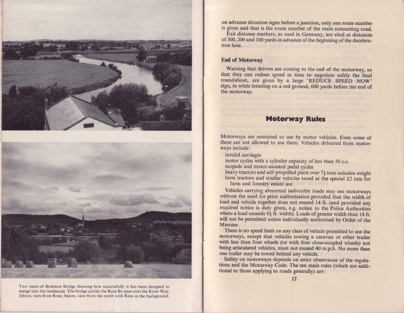
At the western end - actually on the Ross By-pass - the road is carried over the River Wye by the Bridstow Bridge with its associated embankment, 2,000 ft. long, over the river's flood plain.
Bridstow Bridge is a graceful three-span pre-stressed concrete structure 353 ft. long. It has a clear span of 203 ft. in the centre and two approach spans of 75 ft. It is supported by two reinforced concrete piers, one on either side of the river, and by reinforced concrete abutments. The embankment has a maximum height of 33 ft. and is pierced by seven flood relief arches.
Other Bridges
As he speeds over the level surface of the motorway, a driver is scarcely conscious of the engineering feats that have made his smooth journey possible. Nevertheless these feats have been quite considerable.
At the end of the eastern viaduct to Queenhill Bridge, for example, a two-span steel girder bridge was built to carry an unclassified road and single-line railway over the motorway and this involved raising the level of the road and railway by some seven feet.
Other bridge works in Worcestershire include two multi-span viaducts carrying the motorway over areas subject to flooding from the River Severn, one 488 ft. long on the east side and the other 412 ft. long on the west. Both are of dual construction in reinforced concrete.
The motorway has no connection with other roads except at two points - one at Bury Court where the Ledbury-Gloucester road (A.417) is carried over the motorway, and the other at Jay's Green, where it is crossed by the Ross-Newent Road (B.4221). At both points flyover junctions have been built. The second of these flyovers lies wholly in woodland of the Forestry Commission's Dymock State Forest which forms an attractive setting for the road approaches. Cattle grids are provided here to prevent stock straying on to the motorway.
Some major difficulties were encountered near Bury Court, where earth-moving machines sank over their axles into a previously unknown silted fish pond. Monks at one time worked the nearby mill. In the Beaconshill-Dymock Wood area, the motorway rolls through the countryside in cuts and on embankments over culverted ravines and then enters the Dymock State Forest where 25,000 trees had to be removed by the Forestry Commission to make way for its progress.
Construction of the motorway has of course presented big problems of excavation and filling for the labour force of some 1,200 men. Almost 24 million cubic yards of material had to be blasted and scraped from the high points and transported to fill embankments on the lower sections. In addition thousands of tons of stone were imported for the base courses of the carriageways.
Work was started in March 1958. Completion within about two and a half years has only been possible by the high degree of mechanisation and skilful organisation.
The Men Who Built It
Overall responsibility for the engineering practicability of the scheme rested with the Ministry of Transport (Chief Engineer: Mr. J. F. A. Baker). The Ministry initiated the scheme as a whole and has also been responsible for much administrative detail including land acquisition.
The Ross Motorway crosses parts of three counties, Worcestershire, Gloucestershire, and Herefordshire, and in each case the roads and bridges, apart from some of the major bridges, and the bridges in Gloucestershire, were designed by the County Councils as Agent Authorities of the Minister of Transport. These were the Worcestershire County Council (Surveyor Mr. W. R. Thomson), the Gloucestershire County Council (Surveyor Mr. R. A. Downs) and the Herefordshire County Council (Surveyor Mr. D. H. Banks).
Sir Alexander Gibb and Partners are Consulting Engineers for the Queenhill Bridge, and Sir William Holford and Partners are the Consulting Architects. For Bridstow Bridge, Messrs. Scott and Wilson, Kirkpatrick & Partners are Consulting Engineers and Messrs. Ansell and Bailey Consulting Architects. The 11 bridges included in Contract No. 2 were designed by Messrs. W. S. Atkins & Partners, Consulting Engineers.
The scheme was divided into four contracts as follows:
- Contract No. 4, mainly in Worcestershire including the extensive bridgeworks and viaducts over the River Severn, was carried out by Messrs. A. E. Farr Ltd.
- Contracts No. 3 and No. 2 covered the lengths to the Herefordshire boundary including the Bury Court flyover junction and were carried out by Messrs. R. M. Douglas Ltd., of Birmingham.
- Contract No. 1, covering the remainder of the project and including the Ross By-pass and Bridstow Bridge, was carried out by Messrs. Tarmac Civil Engineering Ltd.
Landscape Treatment
Great importance is attached to the landscape treatment of motorways. The Minister has the expert advice of the Advisory Committee on the Landscape Treatment of Trunk Roads under the chairmanship of the Hon. Sir David Bowes-Lyon, and the detailed planting proposals for the Ross Motorway are based on the recommendations of this Committee.
The motorway passes through the picturesque Forest of Dean and affords outstanding views of the Malvern Hills and the mountains of Wales. The alignment and profile of the motorway have been sympathetically related to the hills and valleys of the surrounding countryside, so that the new road will harmonise with the landscape in a most natural and pleasing manner. In order to preserve the wide views which the road will open up to travellers, special planting will be limited to the few points where it will be helpful to emphasize a pleasing prospect or screen an unpleasing one. To help in the harmonising process, such planting as is carried out will be of trees typical of the district, and the cuttings and embankments will be grassed and left to regenerate naturally.
Servicing and Emergency Arrangements
Drivers on the Ross Motorway should remember that there are no facilities (petrol pumps, restaurants, telephones, etc.) with direct access to the motorway itself. When the motorway is connected to the northern section of the Birmingham-Bristol Motorway in the autumn of 1961, these facilities will be provided in a specially arranged service area which will be constructed at Strensham, about half a mile to the north of the junction of the two motorways. On this service area, which will be built alongside the motorway and will have direct access to it, there will be parking spaces, public lavatories, telephones, supplies of motor fuel and oil, restaurants and cafeterias, and facilities for minor adjustments or minimum emergency repairs.
As stops are not permitted on the motorway except in an emergency, a driver should, before entering the motorway:
- see that his vehicle is in good condition, that the radiator is full, that there is enough engine oil, and that the tyres are in good condition and properly inflated;
- see that he has enough fuel to reach his destination or a service area or a filling station off the motorway.
Emergency Telephones
If a driver has to stop in an emergency and needs help he should, if possible, run the vehicle on to the verge alongside the carriageway and raise the bonnet. This will attract the attention of one of the patrols operating on the motorway. Later it will be possible to use one of the roadside telephones which are intended for summoning help in emergencies such as accidents, fires, and vehicle breakdowns; but although work on the system is already being carried out these telephones will not be operational when the motorway is first opened. They will be erected at fixed intervals along the motorway verge and will be connected direct to Police Stations.
The telephone will be easy to operate: all that will be necessary is to pick up the receiver, wait for the Police to answer, and tell them what has happened. The policeman on duty will obtain the necessary assistance.
Note:
- As the telephones will be sited in pairs, one on each carriageway, there will be no need to cross the motorway to reach the nearest telephone.
- The emergency telephone will not connect with the G.P.O. system, and the police operator will not be able to pass a message to anyone apart from the emergency services. Telephones for other than emergency calls will be provided with the other facilities at the Strensham Service Area.
Police Patrols
The Police Forces responsible for the motorway are operating patrol cars with special equipment for emergencies. There are also the patrols of the motoring organisations.
The Motorway Traffic Regulations make it the duty of anyone breaking down mechanically to get his vehicle off the carriageway on to the verge. The same applies to any vehicle involved in an accident but not disabled. The police accident procedure provides that every possible means should be used to get such vehicles moved off the carriageway on to the verge as soon as such prior essentials as warning on-coming traffic, rendering immediate first aid and summoning ambulances, etc., have been done.
Breakdown vehicles will be summoned as required for removing disabled vehicles, by using the emergency telephone system when it is installed. The Police have lists of garages with facilities available.
The procedure for warning on-coming traffic of obstruction by breakdown or accident (until it can be removed on to the verge) will be essentially the same as that in operation on M.1. There the procedure is as follows:
The specially equipped police car summoned to an accident puts down large 'Accident' signs on both verge and central reservation about 900 yards before the scene of the obstruction. These signs, measuring 4 ft. by 2 ft. have white lettering on a red background. At 600 yards it similarly puts down two 'No Overtaking' signs; at 300 yards "Slow" signs. If the road cannot be cleared immediately on arrival, a series of red and white rubber cones is set out diagonally from the site to the edge of the carriageway about 100 yards in advance, at about 8 yard intervals for the purpose of diverting traffic round the obstruction. At night red lamps are placed on top of every other cone.
There is also provision for lighting up the scene of the accident if necessary.
Keeping the Motorway Clear in Winter
To keep the Ross Motorway clear of snow and ice, and so avoid traffic hold-ups and multiple accidents, special arrangements have been made.
The Ministry of Transport is setting up a depot at Bury Court, approximately halfway along the motorway, at which dumps of grit and salt will be kept. There is an auxiliary depot at Ross-on-Wye and there will be another depot at Strensham where the Ross Motorway joins the Bristol-Birmingham Motorway. Based on these depots, and held in readiness for immediate use, are a number of fast and heavy snow-clearing and gritting vehicles of the latest types, developed by the Ministry's mechanical engineers in collaboration with the manufacturers. The County Surveyors of Herefordshire and Worcestershire, the counties which are to maintain the motorway, are responsible for the detailed operations on behalf of the Ministry.
The vehicles will be manned by specially trained crews from the County highway departments. During the periods when frost or snow is expected, arrangements will be made for men to be available on the spot, overnight accommodation being provided at Bury Court and Strensham. Each depot will be given the latest weather forecasts and will be in communication by telephone with other depots along the motorway, with the respective County Surveyors' Offices, and with the Police.
Gritting
Modern elevated hoppers are being built at Bury Court and Strensham capable of loading these large-capacity vehicles with 8 to 10 tons of salt or grit in less than a minute.
Salt or grit will be spread over the whole width of each 24 ft. carriageway at one pass at speeds between 30 and 40 m.p.h. The use of salt in advance of a normal night frost can prevent the formation of ice on the road, and its continued use can keep the roads clear under light to average conditions. Grit will be used if, in spite of salt precautions, ice has formed, whether as a result of compacted snow or otherwise.
Snow Clearance
For snow clearing, high-speed lorries, fitted with straight blade ploughs, will go out as soon as possible after snow begins to fall, and except in blizzard conditions they will be expected to prevent the accumulation of snow on the carriageways. By means of plough blades, the "angle' of which can be adjusted to either the left or right hand, the snow will be thrown either into the central reservation or to the nearside of the carriageway.
In severe conditions the adjustable angle blade ploughs will be quickly detached and replaced by high-wing 'vee' ploughs which can be used to bulldoze a way through drifts up to six feet deep and keep at least one lane open to traffic.
For use in cuttings and to remove snow piled up by the blade ploughs, there is available the latest type of rotary snow plough, or 'blower', which can travel to any point on the motorway at a relatively high speed and on arrival can tackle 6-ft. drifts and 'blow' or throw the snow 50 ft. or more in any required direction.
All arrangements have been planned with the high speed character of the motorway in mind and the necessity for reducing interference with traffic flow to a minimum. For example, the grit spray can be controlled from the driver's cab and can be cut off or deflected whilst overtaking or other movements in traffic are being made.
All these vehicles are painted a conspicuous golden yellow colour and bear large notices indicating by day or night when they are gritting or carrying a snow plough.
Motorway Signs
Clear and simple directions that can be read by drivers travelling at high speeds are the first essentials of a motorway signposting system. Like those on other motorways in this country, the signs on the Ross Motorway are designed and sited so that a driver may read them without so much as turning his head. They can be read in four seconds at the most; during this time a car travelling at 70 m.p.h. covers 400 ft., and the lettering on the signs is large enough to be legible from a distance of at least 600 ft. Other features are:
- Colour: White letters on blue ground.
- Height: The lower edge of each sign not less than five ft. above road level.
- Lighting: All direction signs at junctions electrically lit.
The motorway signposting system was devised by the Advisory Committee on Traffic Signs for Motorways set up by the Minister of Transport and Civil Aviation under the chairmanship of Sir Colin Anderson at the end of 1957. The lettering, layout, symbols, arrows and other features of the signs were designed by Mr. Jock Kinneir, and the Road Research Laboratory carried out experimental work. The system was tried out experimentally on the Preston Motorway and incorporates changes and improvements suggested by experience on that motorway.
Before making their recommendations the Committee studied the signs in use on comparable roads in the United States and Europe. Their recommendations were closer to European than American practice. The principal signs are:
Joining the Motorway
At the entry points to the motorway there are signs showing the classes of traffic excluded from motorways and the rules governing the use of the motorways. It is hoped that when the rules and regulations are generally known it will be possible to replace these signs by a motorway symbol to show that the road is a motorway.
Apart from signs to guide traffic to the motorway from distant places, the first advance direction signs appear at the immediate approaches to the points from which the motorway is entered. These signs, like those on the motorway itself, have white letters on a blue ground. In addition pointer signs are provided at the beginning of the motorway or the slip road leading to it.
On the Motorway
After each junction, confirmatory signs indicating places ahead are provided. These signs include the mileage to the destinations shown.
Confirmation of the route number of the motorway is given on a separate sign.
Leaving the Motorway
Advance direction signs are provided well in advance of the exit and the information is repeated in case a particular sign is temporarily obscured by other traffic. The first advance direction sign, sited one mile before the exit, is intended as a primary warning. Its principal features are, therefore, the junction symbol and the distance to the exit. The route number of the all-purpose road which can be reached from this junction is also included. The second advance sign, sited half a mile before the exit, indicates places which can be reached by leaving the motorway at this point; the distance to the exit is again shown. The final advance direction sign, sited at the beginning of the deceleration lane, repeats this information and adds the forward destination reached by driving on along the motorway.
Direction signs at junctions are electrically lit; those at the mile and half-mile positions from the exit are reflectorised.
On advance direction signs the number of names of places lying off the motorway does not exceed two. Mileages are given, not on advance direction signs, but on the confirmatory signs. Route numbers are not given any greater importance than place names, but on advance direction signs before a junction, only one route number is given and that is the route number of the main connecting road.
Exit distance markers, as used in Germany, are sited at distances of 300, 200 and 100 yards in advance of the beginning of the deceleration lane.
End of Motorway
Warning that drivers are coming to the end of the motorway, so that they can reduce speed in time to negotiate safely the final roundabout, are given by a large 'REDUCE SPEED NOW" sign, in white lettering on a red ground, 600 yards before the end of the motorway.
Motorway Rules
Motorways are restricted to use by motor vehicles. Even some of these are not allowed to use them. Vehicles debarred from motorways include:
- invalid carriages
- motor cycles with a cylinder capacity of less than 50 c.c. mopeds and motor-assisted pedal cycles
- heavy tractors and self-propelled plant over 74 tons unladen weight farm tractors and similar vehicles taxed at the special £2 rate for farm and forestry estate use
Vehicles carrying abnormal indivisible loads may use motorways without the need for prior authorisation provided that the width of load and vehicle together does not exceed 14 ft. (and provided any required notice is duly given, e.g. notice to the Police Authorities where a load exceeds 9½ ft. width). Loads of greater width than 14 ft. will not be permitted unless individually authorised by Order of the Minister.
There is no speed limit on any class of vehicle permitted to use the motorways, except that vehicles towing a caravan or other trailer with less than four wheels (or with four close-coupled wheels) not being articulated vehicles, must not exceed 40 m.ph. No more than one trailer may be towed behind any vehicle.
Safety on motorways depends on strict observance of the regulations and the Motorway Code. The ten main rules (which are additional to those applying to roads generally) are:
- One-way driving must be observed at all times on the dual carriageways.
- There must be no U-turning.
- Vehicles must not stop or remain at rest on the carriageways unless compelled to do so by the presence of any other vehicle, person, or object.
- If a vehicle breaks down or has to be stopped in an emergency, it must, as soon as is reasonably practicable, be moved on to the verge, and, even there, it must not remain longer than necessary.
- Vehicles on the carriageways must not be reversed except in special circumstances.
- Vehicles normally must not be driven on to the verge; nor may they be driven on to the central reservation.
- Vehicles must not be driven on the motorwavs by learner drivers.
- Persons getting out of vehicles in emergency must stay on the verge unless they are giving help or recovering something dropped on the carriageway.
- Animals carried in vehicles on motorways must be kept on board, or if they have to be removed, they must be under proper control on the verge.
The penalty for a breach of any of these regulations is a fine of up to £20 for a first offence.
Motorway Driving
Experience on the London-Yorkshire Motorway has shown that drivers need to give particular attention to the following points:
- Beware of fog and look out for drifting patches of mist. Keep speed well down when there is any sign of these conditions and proceed with great caution.
- Drive slowly and cautiously when it appears that there may be ice ahead.
- Remember that cross-winds, especially gusts, can cause your vehicle to swerve dangerously; reduce speed when it is windy and be alert to apply corrective steering control.
- Unless your tyres are in good condition do not drive fast on the motorway otherwise they are likely to burst. This can be very dangerous.
- Keep the speed of your vehicle well within its capacity for steady cruising otherwise there is risk of engine breakdown which may cause danger to others.
- Start slowing down well before you reach the end of the motorway.
Advice on motorway driving is given in the following extracts from the Highway Code, 1959 edition:-
Motorways have no sharp bends, cross-roads, roundabouts or traffic lights. Drivers joining or leaving them always do so from the left. Crossing traffic or right-turning vehieles are carried either above or below. Because of this it is possible to maintain higher average speeds than on other roads.
Safety on motorways is of first importance and it is essential that all who use them should observe strictly the following additional rules:
General
Pedestrians, learner drivers, pedal cycles, motor cycles not exceeding 50 c.c. capacity, invalid carriages, certain vehicles carrying slow-moving oversized loads (except by special permission), agricultural vehicles and animals must not use motorways.
Make sure your vehicle is in good condition.
Driving for long spells at an even speed may cause drowsiness. To prevent this, drive with adequate ventilation and stretch your legs at the parking or service areas.
Joining the Motorway
Look out for the direction signs at the approaches to a motorway so as to avoid joining the wrong carriageway.
When joining a motorway at an intermediate access point, you will approach it from the slip road on the left. Watch for a safe gap between vehicles in the nearside traffic lane on the motorway, and increase your speed in the acceleration lane to the speed of traffic in the nearside lane before joining it.
Give way to traffic already on the motorway.
If you discover from route confirmation signs beyond the entrance to a motorway that you are going the wrong way continue until you reach the next exit.
DO NOT REVERSE OR TURN IN THE CARRIAGEWAY OR CROSS THE CENTRAL RESERVATION.
On the Motorway
Drive at a steady cruising speed comfortably within your capacity and that of your vehicle.
Lane discipline
After entering the left-hand traffic lane of a motorway, stay in it long enough to accustom yourself to the speed of vehicles in that lane before attempting to move out into a faster right-hand lane to overtake.
KEEP WITHIN THE CARRIAGEWAY LANE MARKINGS and cross them only when changing from one lane to another. Before changing lanes be sure that it is safe to do so, particularly at high speeds. DO NOT WANDER FROM LANE TO LANE.
On a two-lane carriageway, keep to the left-hand lane except when overtaking.
On a three-lane carriageway, you may keep to the centre lane when the left-hand lane is occupied by slower moving vehicles. The outer (right-hand) lane is for overtaking only; do not stay in it longer than is necessary after overtaking vehicles in the centre lane.
DO NOT DRIVE TOO CLOSE TO THE VEHICLE AHEAD OR YOU IN YOUR LANE, allow ample distance between your vehicle and the one ahead according to your speed.
Overtaking
OVERTAKE ONLY ON THE RIGHT. Right-hand lanes will be free from slow-moving and right-turning vehicles. NEVER OVERTAKE ON THE LEFT.
Before pulling out to your right into a traffic lane carrying faster moving traffic, watch out for and GIVE WAY TO TRAFFIC IN LANES TO YOUR RIGHT, USE YOUR MIRROR to make sure that the lane you will be joining is clear for a long distance behind, and bear in mind that an overtaking vehicle may be travelling much faster than you are. Give a clear signal of your intention WELL BEFORE YOU change from one lane to another.
Stopping and parking
Do not stop on the carriageway of a motorway except when this is unavoidable or to prevent an accident, or unless required to do so by the Police or by an emergency traffic sign.
In the event of an emergency or breakdown, pull off the carriageway on to the verge on THE LEFT, but only for so long as may be necessary (an 8 ft. width of the verge adjacent to the carriageway is constructed as a "hard shoulder" strong enough to carry vehicles leaving the carriageway in an emergency). Before you stop, give a left-turn signal as you decelerate and drive completely on to the verge.
Do not park or let your vehicle stand on:
- the carriageway;
- the slip roads;
- the central reservation;
- the verges adjacent to the carriageway or slip roads (except in an emergency).
Use instead the parking or service areas with appropriate facilities which are provided at intervals along the motorway.
Do not walk on to the carriageways or cross them on foot. Take special care to keep children off the carriageway when you stop in an emergency or at a service area.
Dogs and animals
When you stop, whether on the verge or in a service area, or in the event of an accident, keep any animal in your vehicle under close control either in or on a vehicle or held on a lead.
Accidents
If you see a knot of vehicles in the distance, which may mean that there has been an accident, reduce speed at once and be prepared to STOP.
Leaving the Motorway
If you are not travelling to the end of the motorway, watch for advance signs warning you of your point of exit.
To leave a motorway at one of the intermediate exit points, get into the left-hand lane in good time, stay in it, and give a left-turn signal well before you reach the slip road.
Reduce speed as necessary in the deceleration lane on the approach to the slip road.
To reach a destination to the right of the motorway, you will leave by a slip road on your left. After leaving the motorway watch for signs directing you to the right via an underpass or a bridge.
If you miss your exit, continue along the carriageway until the next exit.
When you leave the motorway, remember to adjust your driving to the different conditions of the ordinary road system.
Route Numbering of Motorways
Route numbers for motorways are allocated in much the same way as for existing "all-purpose" roads.
The system on which the existing Class A and Class B roads are numbered is briefly as follows:
England and Wales are divided into six sectors by the six great routes radiating clockwise from London (A.1 to Edinburgh, A.2 to Dover, A.3 to Portsmouth, A.4 to Avonmouth, A.5 to Holyhead and A.6 to Carlisle), sector one lying between A.1 and A.2, sector two between A.2 and A.3 and so on. All other Class A roads in England and Wales have two, three, or four-figure numbers, the first figure of which is the same as the number of the sector in which it starts. In the same way Class B roads in England and Wales have three, or four-figure numbers, the first figure being the same as the appropriate sector number.
Motorway System
For the purpose of numbering motorways, England and Wales will be quartered by the London-Yorkshire Motorway, a possible Channel Ports Motorway, a future Exeter Radial Motorway and the London-South Wales Motorway. These roads will be numbered M.1-M.4 respectively. M.5 will be reserved for the Bristol-Birmingham Motorway, M.6 for the Penrith-Birmingham Motorway (and its eventual extension to join the London-Yorkshire Motorway north of Crick). Two-figure numbers will be reserved for spurs and for motorways lying within the sectors bounded by the single-number motorways.
The system described in the previous paragraph will apply to long-distance motorways. Where, however, a motorway is merely a bypass along an existing route, such as the Doncaster By-pass along Route A.1, it will not be given a separate M number, but the letter M will be added in brackets to the existing route-number, e.g. A.1(M) for the Doncaster By-pass. This will preserve the continuity of the route-number of long-distance all-purpose roads.
In accordance with these principles the Ross Motorway, which will be a spur from the Bristol-Birmingham Motorway, has been numbered M.50.
Planning a Motorway
Before construction of a motorway can begin, an immense amount of preparatory work has to be done both technical and administrative, e.g. surveys of land and soils, designs of roads and bridges, and preparation of specifications, plans and quantities; and, on the administrative side, completion of statutory processes, acquisition of land and invitations to tender.
The procedure is governed by the Highways Act 1959, which, whilst giving the powers to construct a motorway, is designed to ensure that due consideration is given to the requirements of local and national planning including the requirements of agriculture.
Fixing the Route
The first step is to locate a provisional route. This involves not only preliminary surveys and field work, and sometimes aerial survey and trial borings, but also consultation with local authorities and other interests likely to be affected, e.g. Water, Electricity and River Boards and the British Transport Commission. If valuable agricultural land is affected, discussions are necessary with agricultural interests through the Ministry of Agriculture, Fisheries and Food. Depending on the size and nature of the project, these consultations may be completed in a few months or, in difficult cases, may take longer. In some cases a preliminary line will already have been included in a Development Plan and so protected, but even when this is so, the line must be reviewed in the light of objections which may have been made to the draft Development Plan, and must be surveyed in more detail to take account, for instance, of the latest standards of motorway design.
The next step is to make a scheme under the Highways Act which finally defines the centre line of the motorway and protects it from all other development. First, a draft is published with plans of the route. A period of three months follows during which objections may be made. These are carefully considered and a Public Inquiry may have to be held before the Minister decides whether the scheme should be made with or without modification. The process of making a scheme takes about a year if no substantial difficulties are met but it may sometimes be necessary, in the light of the objections, to revise the proposals and go through the whole process again from the beginning.
The next stage is to prepare the detailed designs for the motorway, including junctions, bridges, drainage, etc. Land plans and reference schedules must also be prepared and specifications and bills of quantity drawn up. At the same time proposals are formulated for dealing with roads and footpaths crossing the route of the motorway, which may have to be stopped up or diverted, and the Minister's proposals must be advertised and an Order be made in accordance with the Highways Act by a similar statutory process to that used in making a scheme to fix the line.
Land Acquisition
As soon as sufficiently detailed plans are ready, acquisition of land can begin. Wherever possible, land is acquired by agreement with the owner, but in some cases it may be necessary to make a Compulsory Purchase Order. Before such an Order can be made, it must be advertised in draft form for two consecutive weeks and a three-week period is allowed for objections to be made. If necessary a Public Inquiry or a Hearing may be held to hear any valid objections before the Order can be made. All this may take a considerable time. Additional complications are introduced where re-housing, common land, burial grounds, etc., are involved. To get entry on to land for a scheme of any size usually takes at least twelve months.
Bridge Designs
While the preparation of the engineering details is proceeding, the bridge designs are referred to the Royal Fine Art Commission and the British Transport Commission or other statutory bodies whose interests are affected. When all this has been done, the contract documents completed and entry to the land secured, tenders can be invited by advertisement. On a major contract a reasonable time to allow for contractors to prepare their tenders and for consideration of their offers is at least four months.
To complete all these processes may mean that, for a major scheme, four years or more are needed before construction can be started.