Back in the 1960s, motorway service areas were meant to be found every 12 miles on long-distance routes. Not all of them were needed straight away, but they were all pencilled in and some were even partly built. Here's ten that are still just a set of hopeful sliproads to nowhere.
Looking back at documents from the Ministry of Transport's motorway planners in the 1960s gives you the impression that they considered their job more science than art. The standards they devised called for a motorway service area every 12 miles, and many of those locations were assigned not just locations but also reference numbers. (These people loved numbering things.) On motorways designed in that era, you can follow the route today and see the service areas pop up at remarkably neat intervals of around 12 miles. Try it, for example, along the length of the M6 and you'll find that about every twelve miles there's a service area, except in a few places where there's a gap of about 24 miles because one is missing. And where there's a gap, if you look in about the right place, you'll often find the evidence that services were planned there.
Many of the examples below have four sliproad stubs leading off the motorway into nothingness. If you look on an aerial photo, you'll see that some of them actually had the land purchased and fenced off, unused to this day, making a recognisable hexagonal shape amid the fields. A handful have - or had, at one stage - a bridge or underpass across the motorway that would have linked the two sides. None of them, however, will serve you hot drinks or let you go to the toilet.
1: M6 Harborough Magna Services
Where is it? On the M6 between junctions 1 and 2. It was number SA24. When this section of M6 was originally proposed a service area was pencilled in at nearby Stretton-under-Fosse, but by the time the road was under construction this site was chosen instead.

What was built? Four sliproad stubs complete with road markings leading away into the undergrowth. The road markings are gone but the sliproads are still there. A hexagonal plot of land was also bought which has now been returned to farmland (though its boundary fences remain), and a footbridge - with no steps up to it - hung in mid-air over the M6 until it was demolished in 2004.
Will it ever open? Highly unlikely. Service area operators are now responsible for proposing new sites where they think there is demand from the travelling public. No proposals have been made for anywhere on the M6 between the M1 and M42, least of all here, so apparently there isn't the demand.
2: A1(M) Sprotbrough Services
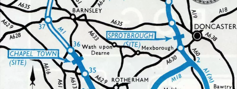
Where is it? The A1(M) Doncaster Bypass between junctions 36 and 37, just north of the bridge over the Don. It was given number SA22.

What was built? Four sliproads connect the A1(M) to some lovely embankments, with link roads to nearby Melton Road. There's no bridge here and no land set aside for the services, and the sliproads are so close together that it's hard to see what the layout would have been.
Will it ever open? Probably not. The sliproads are now used to access a Highways England maintenance compound, and while there's plenty of passing trade and proposals have been made for new services in this area, none of the proposals would use this site.
3: M1 Chapel Town Services
Where is it? North of Sheffield on the M1, at what is now junction 35A. The MOT called it SA36.
What was built? Four sliproad stubs leading away to nothing. No land was set aside here. You can still see two of the slips, to and from the north, untouched since the 1960s. The south-facing pair are still there too, but in a modified form: when junction 35A was added to the motorway it recycled the stubs, and the sliproads leading away to the A616 are where the service area was meant to be.
Will it ever open? No, don't be silly. There's a junction in the way now.
4: M1 Long Whatton Services
Where is it? Between M1 junctions 23 and 23A, on the stretch between Loughborough and Nottingham, and known to its friends as SA18.
What was built? It's another site with four embryonic sliproads that go nowhere, now fashionably accessorised with black and white chevron signs, presumably because people were sometimes veering off the motorway to see where they went. The bridge carrying Smithy Lane over the M1 is extra wide to clear the south-facing sliproads.
Will it ever open? No. It now sits just south of junction 23A, and anyone looking to site a service area would put it just north of there where it will pick up trade from the A42 as well. Just north of junction 23A is, of course, where you'll find Donington Park services. They were put there for exactly that reason, and they make Long Whatton entirely redundant.
5: M40 Abbey Barns Services
Where is it? On the original stretch of the M40 between junctions 3 and 4, near High Wycombe. It wasn't allocated a number.

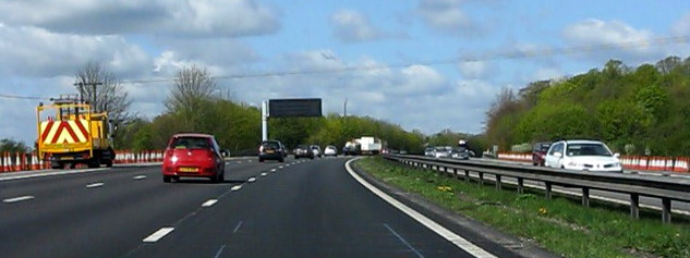
What was built? It's another site with four sliproad stubs, but no land was provided. Just like Long Whatton, confused drivers on the M40 are kept in their place with lots of black and white chevron signs, so you can't miss it.
Will it ever open? No. Attempts were made to develop the site in the 1970s but environmental concerns about the effect it would have on the landscape skewered it. Since then, services have been provided to the west at Oxford and the east at Beaconsfield, and nobody is looking to slot another service area in between them.
6: M5 Newland Common Services
Where is it? It's 28 miles from Frankley to the next services on the M5 at Strensham. Halfway between them, just where you'd expect to find it, is the site for Newland Common. It was also sometimes known as Droitwich Services.
What was built? A strangely irregular plot of land was set aside and fenced off - much smaller than most on this list, but then the M5 was one of the earliest motorways to open and many early service areas were impractically small. Four sliproad stubs were built too, but obliterated when the motorway was widened in the 1980s. You won't spot anything from the road now.
Will it ever open? This section of the M5 has a lot of passing trade and might support a new service area, but if one is ever built it's unlikely to be here. The site is too constrained and it's very close to a built-up area.
7: M18 Hatfield Services
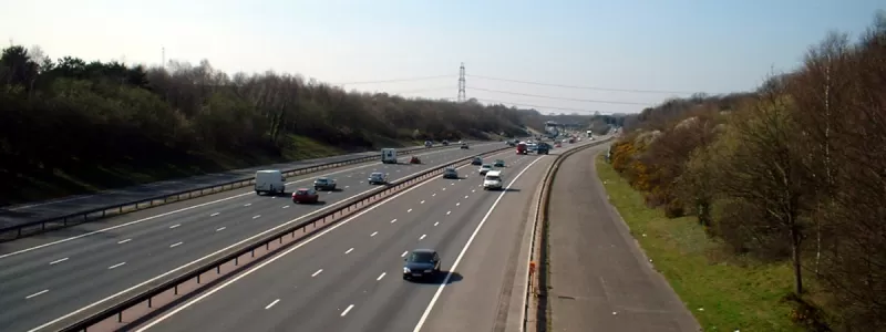
Where is it? On the M18 just south of junction 5. The northern half of the M18 is characterised by running in straight lines through flat and uninteresting terrain so if you can spot this unbuilt service area it's genuinely exciting.

What was built? Four sliproads (of course) lead into a vast hexagonal plot of land, long since freed of its original role as working farmland, and now taking on the appearance of a pleasant meadow with trees. By the 1970s lessons of early, small service areas had been learned and Hatfield would have been a monster. A pedestrian subway was built too, hard to see from the road but obvious in aerial photographs.
Will it ever open? Never. When services were eventually provided on the M18, it was at Doncaster North, leading off the roundabout at junction 5 just a couple of miles away. That site cunningly captures traffic travelling in all directions between the M18 and M180, which Hatfield Services could never have done.
8: M11 Chigwell Services
Where is it? Motorways travelling out of the capital were meant to have a service area 12 miles from Central London. Heston on the M4 is exactly that far while Scratchwood (sorry, "London Gateway") on the M1 is 11 miles out. Between junctions 4 and 5 of the M11, a neat twelve miles from Charing Cross, is the site for Chigwell Services.
What was built? Four sliproads again, and another big hexagonal plot of vacant land. Chigwell is possibly unique in having paved roads around the perimiter of the site linking its sliproads together, along with a bridge over the M11 connecting the two sides. They are there because there is now a police facility on the site where motorway patrols are based. A pedestrian subway passes under the M11.
Will it ever open? In the years before the 2012 Olympics, the southbound side was paved in its entirety and used as a marshalling and security screening site for lorries supplying the construction works at the Olympic Park. Its operator, DHL, was offered the site when the work was finished, but they decided they didn't want it, so the tarmac was completely torn up and the site returned to grass. There has never been much commercial interest in the site, though the Road Haulage Association thinks it would be a useful place for a truckstop.
9: M27 Whiteley Services
Where is it? On the M27 between Southampton and Portsmouth, just east of junction 9. It's 12.7 miles east of Rownhams Services, a fact that will come as no surprise to you at all by now. It was also known at various times as Meon, Meon Valley, Titchfield, Fareham and The Services Formerly Known as Prince. (OK, we made up the last one, but the others are real suggested names.)
What was built? Whiteley would have been so close to junction 9 that the two would have been linked together. Long parallel roads were built alongside the M27 to enable this. Westbound, traffic exiting towards junction 9 runs along a mile of this parallel service road, complete with its own sliproad stubs toward the service area. Eastbound, the parallel road is unused and unloved at the other side of a crash barrier.
Will it ever open? A never-ending carousel of proposals have been made to build a service area here, and planning permission was even granted in 2001, but the developer backed out. There are now local concerns about further development in this patch of suburban Hampshire, but the County Council and Highways England are both keen to see more facilities on the M27, so perhaps one day these services will Meon business.
10: M3 Kempshott Services
Where is it? On the M3 near Basingstoke, between junctions 5 and 6, ideally placed 13 miles after Fleet Services and just before junction 7 where traffic splits between the M3 and A303. It would have been number SA14.
What was built? Four more ghost sliproads leading away into the trees, though only those on the westbound M3 survive. Land was also bought here, and prepared by having the woodland cut back, leaving a very roughly hexagonal plot of land. For a time Kempshott was to be the first service area on the M3, but for various reasons Fleet came first and this site never became a priority. In recent years the plot for the eastbound services was lost to a new housing estate, Wedderburn Avenue, which neatly preserves the outline of the site. The westbound has been returned to farmland and now has an access road to a farm passing through it.
Will it ever open? With one half of it physically gone, and Winchester Services opened in the last couple of decades not far to the south, you'd think not. Surprisingly, though, a company called Applegreen who operate many service areas in Ireland have expressed an interest in developing the westbound side at Kempshott on an even bigger scale than originally intended. Perhaps that means there's hope yet.
All these and more
If you've got a taste for unbuilt service areas (or indeed service areas in general) Motorway Services Online has a list of all those that have been proposed but never built, currently running to 66 in total - though not all of them have anything visible on the ground like these ten. They also have a complete listing of MOT service area numbers and, it goes without saying, full and detailed information about everything mentioned on this page.
Comments
Indeed there are, as I've had a look at the (predictably dreadful) proposed signing drawings, and requested more than one or two revisions. Got to love S278s...
Wasn't there a footbridge over the M11 at Chigwell too? I vaguely remember it soon after I passed my test, but it vanished.
A fascinating article. The MSA industry has a lot to answer for, not least in the waste involved in funding the planning and in some case, construction, of these unused facilities. From an environmental and sustainability perspective, much good farmland has been taken out of agricultural use for no gain whatsoever. If there were any justice, the planning system would now redress the balance by insisting that these sites should be developed before any new MSAs involving additional agricultural land-take are approved. The MSA industry and planning circus needs to clean up its act and not be so environmentally irresponsible.
Interestingly, the MSA industry has nothing to answer for. All these "ghost" sites were part-built by the Ministry of Transport (or its various successors) in an era when the policy was to select and provide for service areas and then invite tenders for companies to operate them. Some of those above reached the stage where tenders were invited but no companies wanted to build or operate them. That policy was abandoned decades ago, and these days MSA operators may suggest sites themselves, based on likely trade, and these applications can be approved or turned down. So what you see above are the results of the previous policy, where civil servants selected service area sites at 12 mile intervals without much concern for their commercial viability.
The easiest way to fix the loss of farmland is to do what has already been done at several of these locations, and just sell off the land.
I believe there is also an unbuilt services on the M1 between junctions 19 and 20. It was recently used as a compound for the J19 improvement.
I think that here there is an abandoned/unbuilt service station
https://www.google.co.uk/maps/@53.2099797,-3.0144396,469m/data=!3m1!1e3…
If you mean the large area of unused tarmac on the southbound A494 just before the Dee Bridge, that dates from 10-15 years ago when the road was widened and the road was meant to be widened to carry four lanes plus hard shoulder over the river. The widening scheme south of there never happened. It's very unlikely that a service area would be built over a river!
You've mentioned very anonymously, "a company called Applegreen" - in fact, it is now becoming quite popular as petrol stations on their own, but, what's more, they also now own one of our leading motorway services companies - that is to say, they own Welcome Break.
The set of slip road stubs, and the underpass, which would have become Clifton Services on the M6 in Cumbria, about 2 miles south of J40, are clearly visible on the 1:25000 mapping.
Something going on between junc 12-13 M5 just north of Standish Lane- if anyone can enlighten me?
The site for Moreton Valence services. There are stub sliproads and a hexagonal area of land was set aside, though it's since been returned to fields.
Ah hah! Cheers Chris.
Chris, just read an article on this. Apparently one of the concerns at the time was that it was 'an area of sensitivity'. It doesn't appear to be a concern now though, as they've put a blooming great incinerator in the area- much to the locals understandable annoyance.
Amusingly, Google Streetview has been up the A1(M) Sprotbrough slip roads so we can all take a look! https://goo.gl/maps/gbqJv3ft27sqYHN68
There was one planned for a place called Clifton to the south of Penrith on the M6. And when travelling south bound you can see the slip roads to the services, or should I say what remains of them. I thought that they were staging areas for wide loads!
And Clifton claims to be the site of the last battle on English soil.
Add new comment
Sources
- Historical information: Unbuilt Services, Motorway Services Online.
- Service area numbers: MOT Numbers, Motorway Services Online.
Picture credits
- Photograph of the M6 from Montilo Lane taken from an original by Peter Mackenzie and used under this Creative Commons licence.
- Ordnance Survey mapping of Harborough Magna and Kempshott is Crown Copyright, under fair dealing rules where small extracts of the original have been taken for educational and research purposes.
- Photograph of the sliproad at Sprotborough is taken from an original by N Chadwick and used under this Creative Commons licence.
- Map extracts showing Chapel Town, Sprotborough and Newland Common are taken from "Know Your Motorways" (RAC, 1968), used under fair dealing rules for educational and research purposes.
- Photograph of Smithy Lane Overbridge taken from an original by Anthony Parkes and used under this Creative Commons licence.
- Photograph of maintenance vehicle at Abbey Barns taken from an original by Peter Whatley and used under this Creative Commons licence.
- Photograph of "motorway countryside" at Hatfield taken from an original by Oxana Maher and used under this Creative Commons licence.
- "Birds of a Feather" publicity photo is copyright BBC and used under fair dealing rules for review and satirical purposes.
- Photograph of the sliproads to Whiteley Services is by Steve Peter and used with permission.


M6 Harborough Magna Services:
There are currently plans to construct a new MSA at J1, to be operated by Moto, so I guess they think there is the demand after all!
https://www.moto-rugbyservices.com/