
"Imperfectly Odd" is a new series of occasional blog posts that will explore some of the most strange, unexpected and fascinating features of the UK's road network. Some might be familiar to you, others definitely won't be.
In this first Imperfectly Odd outing, we'll take a trip to northern Lancashire to see one of the most peculiar motorways in the UK, and one with the strangest history: the easily overlooked A601(M).
What's so odd about the A601(M)?
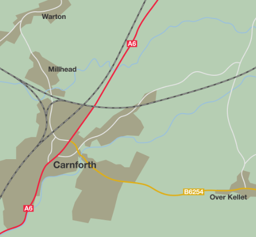
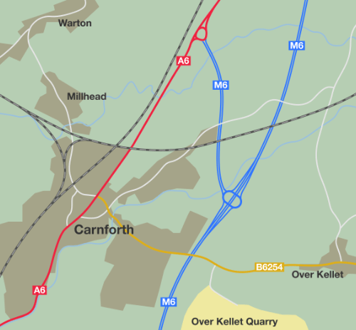
You'll find this road in Lancashire, just off the M6 at junction 35. It forms a sort of northern bypass for the town of Carnforth, and links the M6 to the parallel A6.
If you turn off at junction 35, you'll find yourself at a roundabout where you can go east or west. To the west, the A601(M) is a two-lane motorway running about a mile to a roundabout on the A6, where it stops. To the east is a single carriageway road that will carry you a few hundred yards to the B6254, where it ends on a Give Way line.

For road enthusiasts, the most notable feature of the A601(M) has always been that both the roundabout and the short link to the B-road were part of it - making it a motorway that stopped at a roundabout and which included a length of single carriageway road where you could legally travel at 70mph. It's also a relic of the earliest days of the motorway age: the A601(M) is part of the third oldest motorway in the UK, and hides a strange disused bridge.
The story of a strange spur
To properly understand this very strange corner of the road network, we should really begin in the 1950s, when Carnforth was a small town on the busy A6 linking England to Scotland, and just like other towns on the route between Manchester and Carlisle, it needed a bypass.
Being on one of the worst lengths of the A6, Carnforth didn't have to wait. A length of brand new M6 opened in April 1960. This was the northern end of the Lancaster Bypass, but it also took traffic past Carnforth, returning to the old A6 just north of the town.
The Lancaster Bypass was always designed to be part of a longer motorway, which explains a very sharp corner on its route just east of Carnforth. The corner was meant to become a junction, with the M6 continuing north, and the remainder of the original bypass becoming a short spur.
The section of motorway between the sharp turn and the A6 is, of course, the road that later became A601(M) - meaning that this little-known spur is one of the oldest motorways in the UK. Only the M6 Preston Bypass and the first section of M1 are older.

That was the situation until October 1970, when the Lancaster to Penrith section of M6 opened to traffic. The sharp corner became a new interchange, now known as junction 35, and the link from there to the A6 became a short spur, though it was still (for now) part of the M6.

The changes in 1970 created one of the A601(M)'s many oddities. The Lancaster Bypass had crossed the Lancaster Canal on a pair of concrete bridges, but they happened to be exactly where the spur road would now meet the roundabout. That meant the southbound bridge was in the wrong place, and a new one was built alongside at a suitable angle for traffic approaching the junction.
Today, in the little triangle of land formed by the road and the roundabout, you can still see a disused bridge carrying nothing but grass over the canal. It was used for just ten years, and has been disused for the following fifty. It's unlikely it will ever serve any useful purpose again, other than its present role of keeping the rain off a bit of the canal.

Away from the motorway, a large quarry was opened up at Over Kellet. Large volumes of heavy trucks and other vehicles needed access to the quarry, of course, and most of them were heading to or from the M6.
But the history of Carnforth's connection to the motorway meant that the only route was to travel in to the town on the B6254, pass right through the centre, and then out on the A6 to find the link road towards the M6. This was inconvenient for people working the quarry, and it was - understandably - deeply unpopular with the residents of Carnforth who thought the days of lorries thundering through their town had ended in 1960.
Salvation arrived in 1987, when a short link road was built between the roundabout at M6 junction 35 and the B6254. The road was only 600 metres in length, but it cut the distance from the quarry to the M6 by more than three miles.
This was the UK's first length of single-carriageway motorway (the now-defunct A6144(M) followed later the same year, and the Walton Summit spur from the M61 and M65 arrived a decade later), and when it opened the Department of Transport decided that the Carnforth spur now qualified for a motorway number all its own.
For reasons nobody has ever been able to adequately explain, they called this strange new motorway the A601(M). The number makes no sense because it's not a motorway-standard section of A-road, and even if it was, it has absolutely nothing to do with the A601, which is the number for part of the Derby Inner Ring Road. At its nearest point to the A601(M), the A601 Derby Inner Ring Road is some 157.4 km (98 miles) away.
For the last 30 years, this little leftover from one of the earliest motorway projects has been one of the UK's weirdest motorways: not much more than a mile in length, part single carriageway (though still with a 70mph limit), stopping to pass around a roundabout where it meets the M6 and ending on a B-road at a Give Way sign.
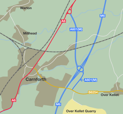
Nowadays, though, an access point to a major interurban motorway is a commercial opportunity not to be missed, and Lancashire County Council (who maintain the A601(M)) had their eye on the wedge of land between the M6 and the link road towards the quarry. They have now sold this land, which will become home to a dealership for sports cars, and have gone through the legal steps to declassify the single carriageway section of road, along with the roundabout at junction 35, turning both into a branch of the B6254.

Odd in a whole new way
At the time of writing, the signs haven't yet changed, so on the ground it still looks like the A601(M) includes a length of single carriageway road and a roundabout, all subject to a 70mph limit. Sooner or later the signs will change and the new status of those roads will be clear.
But the A601(M) is still a very weird road; it's just weird in a new way now. A description of the road today would be a short dual carriageway link from a roundabout on the A6 to a roundabout at M6 junction 35; a motorway that is only linked to the motorway network via a roundabout that is part of a B-road.

Today you can see the new layout of this peculiar motorway in our Motorway Database listing, for as long as it still survives. There have been proposals floating around for several years to declassify the rest of the A601(M) so that a roundabout can be built midway along the remaining length, providing access to new leisure facilities alongside the road - but so far these have come to nothing.
Even better, if you happen to be passing through northern Lancashire on the M6, you can come off at junction 35 to do a lap of it, and be back on your way in the space of about five minutes. It's well worth your time if you enjoy a weird bit of motorway history.
We'll be sharing another Imperfectly Odd story soon.
Further reading
![]()
Comments
There's also now plans to build houses off the dualled section of the A601(M), involving a new roundabout apparently: https://www.lancs.live/news/lancashire-news/158-new-houses-coming-carnf…
The plans in that article seem to very carefully split the new area with the current housing estate, so they don't create a rat run from the A601(M) to Carnforth when the A6 is busy past Truckhaven into the town (which happened very often pre-Covid). Now I'm certainly no expert in the area, but I wouldn't expect that would be allowed unless the dualled section also had its motorway status removed, as you couldn't access it as a provisional driver or with a vehicle that's not allowed on a motorway (foot and bicycle traffic is catered for with a link however)
So will the A601(M) be retired completely soon I wonder?
Great article. I (think) there are a few more anomalies here; 1) As you head west on the B6254 Kellet road and are turning right to head up the A601M, shouldn't the signs for (A6) have a white background. 2) when coming off the M6 (both north & southbound) shouldn't the signs for the A6 & B6254 also both be on white backgrounds. 3) when coming off the A6 to join the A601M at the roundabout, the sign for M6 should be in brackets (as they properly are on the A6 approaches BEFORE you get to the roundabout). 4) when doing the same movement, the sign for the B6254 should again be on a white background 5) There is only one 'End of Motorway' sign and that is right at the T junction with the B6254. 6) No 'No Entry' sign(s) to stop people heading north on the southbound M6 off-slip. I may have missed a few more.
Great story.
I had to check it out on google maps.
very odd.
It's a single lane motorway in each direction. Kind of throws the highway code definition
Even the real A601 has its quirks. The number is not displayed on any road signs, only the destinations; e.g. Burton (A38), Matlock (A6), or Nottingham (A52). Also it is a Zone 6 road that goes into Zone 5 (Derby is on the 5/6 border) though the junction numbering does start in Zone 6.
I'm of the opinion that, rather than have the B6254 split in 3 directions, they should (or should have) declassified the whole A601(M) to a different A road number, something area appropriate. Even the A6254 (if it's not in use).
Unless they can give a dedicated on slip to the dual carriageway section (at least onto the M6 North), there's basically not much use of having a separated section of motorway.
Or even declassify the original road and route the B-road along the former A601(M)
Don't be ridiculous - that's a far too logical and simple solution.
Very odd indeed. Personally I'd have been more flamboyant (why not?) and changed the southern terminus to a roundabout and dual it all so you could have a 3 level stack or something like that for J35; but money talks I guess...
I don't understand why they didn't just declassify the whole thing when the single carriageway link was built.
That was very enlightening - I wondered what they were building of the B6254. When you point it out, it's obviously a Porsche dealership, and also explains the separate building going up there. Mystery solved.....
Seems to be no reason it's a motorway - as it links the A6 roundabout to the B6254 roundabout above the M6.
They have changed it to a B road now, you can see it on google streetview
I don't understand why they didn't just build the 'bend' in the M6 on what was eventually going to be the connection to the roundabout. Would have saved on building an extra bridge when it was all connected up.
As with most government decisions, probably because it was "cheaper now", and the future additional expense would be someone else's problem.
The route of the M6 between Junctions 35 and 40 was not determined at the time the J33 - 35 stretch was constructed, so an alternative connection was still being discussed at the time. It must be borne in mind that the 'Hampson Green to North of Carnforth Special Road', as it was originally known, was actually the first to be authorised (though not the first to open) under the new Act, and motorway design was in its infancy. A similar arrangement existed at J32 at Broughton, and significant changes had to be made to connect the M55. Even now, the link roads between the M6 at Junction 32 and the M55 at Junction 1 are well below standard, showing how dramatically things have moved on in the last 70, and even 50, years.
A601(M) now A6070
Although the dual carriageway is now A6070, travelling South and leaving the motorway there last weekend, the signpost off the M6 still said A601(M) - so they are signing to a defunct motorway! I didn't use the M6 Northbound, but from Google Maps in October 2024, it looks like it still also signs to A601(M) in that direction, too. There are no signs for A6070 until you actually leave the motorway.
It's worth commenting, too, that the roundabout has been upgraded from B6254 to A6070 according to the latest OS mapping.
& B6601
Add new comment
Picture credits
- Photograph of the start of the A601(M) is taken from an original by Ian Capper and used under this Creative Commons licence.
- Photograph of A601(M) start of restrictions and two-way road sign is taken from an original by Johnathan404.
- Photograph of disused bridge © 2020 Google.
- Photograph of end of motorway sign is taken from an original by A68nick.

.jpg)
_Single_Carriageway_at_the_junction_with_the_B6254_-_Coppermine_-_2060.jpg)
So declassifying the roundabout from motorway to B road gives non permitted motorway traffic taking the B6254 spur an escape route by doubling back on itself. Surely then there is nothing stopping the M601 also being declassified as non permitted motorway traffic is able to do the same manoeuvre.