The wait is over! The full map of the Ringways, London’s unbuilt urban motorway network, is now online.
If you’ve been following Roads.org.uk for a while you’ll know our Ringways pages are a long-term work in progress. We’ve hosted a mini-site covering this epic research project into London’s unbuilt roads since 2006, but over the last eight years we’ve been progressively updating and expanding our coverage to provide detailed articles on all the unbuilt roads. Getting to this point has required twenty years of archive research.
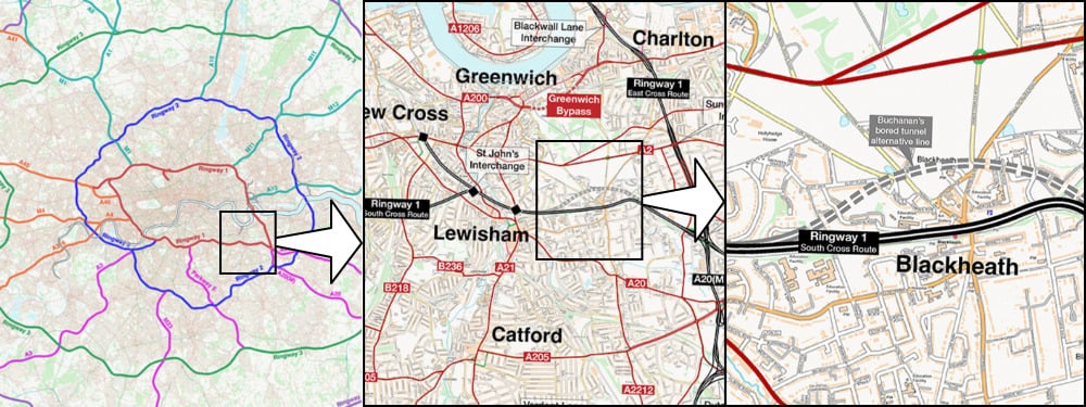
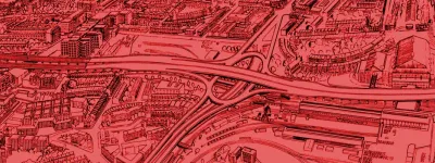
At the top of each page you’ll see a route map showing you the motorway in question, complete with all its junctions and connections to other roads, both real and planned. Those route maps are small extracts from a London-wide map that has been assembled in stages since 2016 but which, until now, has been under wraps.
Today it’s finally available for you to explore.
See it for yourself
To take a look, just head to SABRE Maps - the online map archive of the Society of All British and Irish Road Enthusiasts, which brings together hundreds of historic maps of the UK from the 20th century, which you can zoom, scroll and layer on top of each other to compare changes over time.
Roads.org.uk has teamed up with SABRE to host the Ringways maps because SABRE’s incredible mapping is light years ahead of anything we could provide, and it gives you the chance to overlay the Ringways onto other historic maps to see how they would have fitted in to London in the 1960s and 70s.
It’s just the latest in decades of collaboration between our two sites, and if you’re reading this but you haven’t yet visited SABRE… what are you waiting for?
See it like it’s never been seen before
It’s worth explaining just how unique this map is. Nobody has ever compiled a map of the Ringways before. This is the first map of its kind and it is totally, completely unprecedented.
By that we don’t just mean that no researcher or historian has ever made a map of the routes as part of their research. We mean that no complete map of the Ringways has ever been made, including by the people who designed them.
The planners, engineers and politicians who devised and promoted the Ringways back in the 1960s and early 1970s had an idea of the network they were creating, of course. They had high-level schematic maps of the pattern of roads they wanted to produce, but most were little more than thumbnail sketches.

Detailed plans and engineering drawings of many routes were made, but they were made in isolation. Since the work was split between the Ministry of Transport and the Greater London Council, and each of those designed some schemes in house and outsourced others to firms of consulting engineers, and many different firms were employed at different stages, the plans that existed were for individual projects and no one person or authority had access to them all.
As a result, there was no plan of the whole system that showed more than approximate lines on a map. In the 1960s, you could not have seen how all the schemes fitted together, how every route and every junction linked up, how the Primary Route Network connected to and complemented the Secondary Route Network. The people who designed the Ringways, in other words, never saw the complete picture that they were creating.
But you can. For the first time, the Ringways Map puts it all in one place.
Exploring the Ringways
SABRE Maps is easy to use, but if you’ve never been before, this is your quick guide to making the most of it.
You can choose map layers from the menus, by selecting a category and then a specific layer, or use the Sheetfinder (also in the menu) to see which maps are available in a given place. The Ringways Map layer is under the “Highway Plans” category, but the link above will take you straight there.
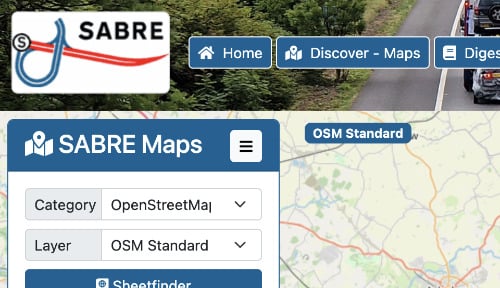
To move around, just drag the map. You can zoom in and out, and you’ll see the map changes as you do. At distant zoom levels there’s a colour coded overview that shows you the overall Ringways network and how the different routes fit together; the colours match the ones we use to group the routes on our main Ringways page. As you zoom in closer you’ll see the districts of London, roads and junctions labelled up, with more detailed labels the closer you get.
The map uses fairly simple conventions - the main one is that roads classified by the Greater London Council as being part of their planned Primary Road Network (PRN) are black, while those in the Secondary Road Network (SRN) are red.
| GLC Primary Route Network |  | Primary Route |
 | Approximate or assumed line of Primary Route | |
 | Primary Route in tunnel | |
 | Primary Route cancelled or deleted before start of GLDP Inquiry | |
 | Junction of unknown layout on Primary Route | |
 | Junction of unknown layout cancelled or deleted before start of GLDP Inquiry | |
| GLC Secondary Route Network |  | Secondary Route, dual carriageway |
 | Secondary Route, single carriageway | |
 | Secondary Route in tunnel | |
 | Junction of unknown layout on Secondary Route | |
| Other symbols |  | Other main roads outside Greater London, dual carriageway |
 | Other main roads outside Greater London, single carriageway | |
 | Greater London boundary |
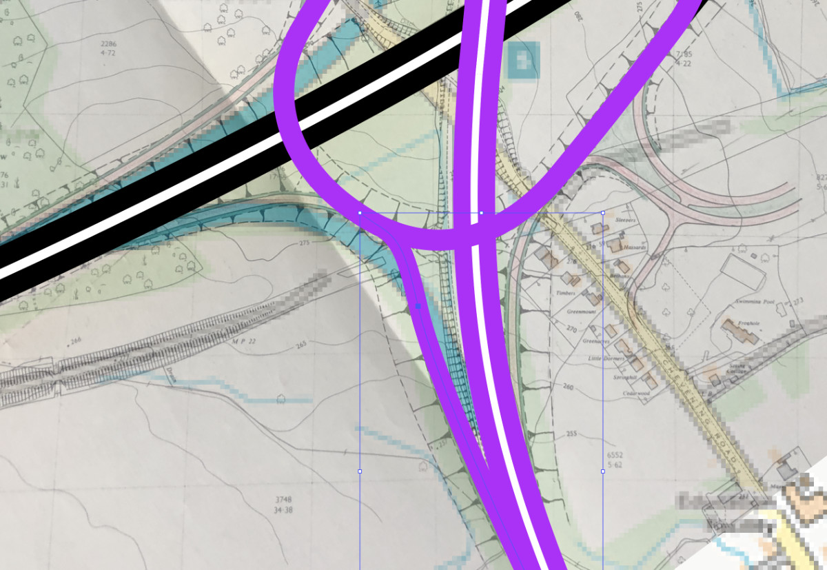
The map is overlaid on modern-day Ordnance Survey mapping, and at closer zoom levels the width of the lines is about accurate for the width of the roads involved, so if you see a building obscured by a line it would almost certainly have been demolished. The exact width of the black lines representing the PRN, for example, matches the width of a dual four-lane motorway with double hard shoulders, which was the expected standard for significant parts of the network.
Then, to see the roads against older mapping, you just need to switch on the Map Fader.
SABRE Maps has just had a major upgrade to its Map Fader feature. Previously it let you put a modern OpenStreetMap layer over the top of whatever you were looking at, and fade it in or out to compare the two. But now it lets you choose any other layer on SABRE Maps, and we strongly recommend you have a look at the Ringways against the OS One Inch map of London from 1971, which shows you the city exactly as it stood when the motorways were planned.
To try it out, just select Map Fader from the SABRE Maps menu, then choose “OS One Inch Tourist” > “1971 One Inch Tourist”. You can use the slider to fade it in and out over the top of the Ringways and see how they fit together.
Highlights
There’s lots to explore on the full Ringways Map, since large parts of it have never been available before - what you’ve seen on the Ringways pages have been a series of small extracts, and the full map shows you much more of London at much closer zoom levels.
We won’t spoil all the surprises, but you might like to look for the following as you look around.
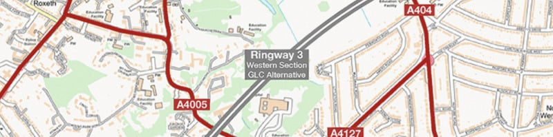
In North West London, there’s the full route of the GLC’s 1965 alternative plan for Ringway 3. They didn’t like the Ministry’s proposals at all and came up with their own suggestion, which was an urban route through Harrow and Stanmore. The plan is described in detail on our Ringway 3 Western Section page, but its route hasn’t been available on the map until now.
If you switch on the Map Fader, you’ll find all sorts of places where the Ringways dodge through gaps in the urban area that have since been closed up, helping to explain their routes.
Have a look, for example, at the Ringway 4 South Orbital Road’s line around Fetcham, where a neat gap existed for the motorway to pass through, or the A13 Relief Road south of Dagenham, whose exact alignment turns out to have been carefully chosen to thread its way through the buildings of the Ford motor plant.
And if you’re interested in New Towns, it might be worth scrolling north east to Harlow. (You won't be able to compare it with the 1971 map, but it goes well with the 1974 Landranger... or just on its own.)
The publication of the Ringways Map means our Ringways mini-site is almost complete - this is one of the biggest and most complicated elements, and it’s now online. To get to this point has taken years of work to produce the map itself, and considerable effort from SABRE’s development team to create new Map Fader functionality to allow different map layers to be selected. One of the reasons it’s taken so long to get here is that we wanted to wait until all the features were in place before launching it.
We’re incredibly excited to share the map with you. It’s full of surprises. Let us know what you find in the comments below.
Thank you to the SABRE Maps team for all their support in hosting the Ringways Map - especially Steven Jukes (also of Pathetic Motorways) who took care of georeferencing and testing, and SABRE’s developers who created and deployed new software features that made all this possible.
![]()
Comments
Definitely a cool map, and it was also certainly a rather ambitious project. I'm not sure if there are even many large cities/metro areas over here in the US that have/had any kind of (proposed) freeway network that could compare with the scale of the proposed Ringway network for London outside of Los Angeles and/or New York City.
Excellent map, Chris. Good content as always! Just a couple of notes (I hate being pedantic) -
1. Your overview map (coloured Ringways) still has Ringway 2 going along Bowes Road in Bounds Green rather than flying over it to miss the section entirely.
2. Your text mentions Feltham, when I think you meant Fetcham (it's obvious where the gap for the South Orbital was, and where Ringway 4 was meant to slot in)
Thanks Andy!
I think the overview map is correct - it was certainly made using exactly the same vectors, they're just drawn with thicker and more colourful lines. A lot of fine detail was lost in scaling them up so some things like this are harder to make out. If you look closely you can see the green line of the existing North Circular/Bowes Road on the base mapping just below the blue line of Ringway 2 in that area, so it's definitely shown north of Bowes Road.
Feltham is definitely a typo for Fetcham and I've fixed that, thank you!
This map really highlights just how ruinous it would've been for some parts of London including whoever was landed with maintaining non-trunk sections of the system.
It also really shows how over-optimistic they were in thinking all this could be delivered with British planning idiosyncracies by the 1990s.
Absolutely stunning piece of work; endlessly fascinating. Thank you for all the hard work that has gone into it. This really should be available as a paid-for poster that would adorn the walls of many of those with a roads interest (me, for sure!!)
My family lived in Norbury in 1960s, moving out to Surrey in 1967, just ahead of Ringways ideas grabbing public attention, as we recall. I now see that the planned Norbury junction was less than half a mile from our home!
In the late 70s a blight hit Norbury, established shops and businesses shut down etc etc.
The family always remarked on how lucky we were to have moved in time.
I cant work out how to use this map at all - the 'fade' feature? no idea
A masterpiece, as always, thank you so much for all your hard work Chris!
Seeing this map, and previously the "might have been" map on Pathetic Motorways, has always made me wistful for the future that never was. Perhaps it is for the best that it didn't happen, Los Angeles being a go-to example of a city with a (mostly) complete Motorway network being a cautionary tale. But on the other hand, one does have to accept that some journeys by private vehicle will always be necessary, and London's infrastructure is woefully inadequate even for those that do still brave taking to the roads - particularly in the south, due to the absence of the M23 and Ringway 2, or really any major roads to speak of.
Personally I think four concentric rings was probably overdoing it, but the modern M25 plus a completed Ringway 2, with the radials all reaching R2, would have helped enormously and been a reasonable compromise.
As Los Angeles shows, there are lots of essential journeys, but also lots of non-essential journeys, and you can't ever build sufficient capacity in a city to meet all non-essential journeys because public transport is competing for road traffic and usually looking more attractive in terms of convenience and (with cars) the upfront and maintenance costs not being directly coupled to each journey.
If every single ringway had been build they'd all have variable speed limits and congestion unless road pricing had been introduced making travelling on the M25 at 8am more expensive then travelling on a deserted road at 2am.
Add new comment
Picture credits
- Sketch map of Ringways network is extracted from GLC/TD/PM/CDO/07.
I am overjoyed to see this, well done and thank you for all your work over the years! There used to be a Ringsways kml file available that I had on Google Earth many years ago, are you considering creating one for this map too?
As it happens I was looking at the East Cross Route on Google Maps today....I am now going to lose many, many hours fading between all sorts of maps in the background.