At all levels of Government, the darkest days of Europe-wide conflict seemed to create an incredible desire to look ahead and plan for the good times. It's widely known that some of the most influential town planning reports were published during the Second World War, and in particular, the County of London Plan and the Greater London Plan of 1943 and 44. The Ministry of Transport got in on the act as well, and in 1942 created the very first official proposals for a motorway network.
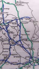
In May 1942, a civil servant called CG Hollingshurst put his name to a report demonstrating the need for a basic set of new high-speed roads for transporting goods around the country. He selected a small number of routes that were intended to connect the main centres of industrial activity to the ports, and whose routes were chosen to relieve the trunk routes where on-line improvement would be most difficult. He suggested five new roads that he thought would "merit consideration" as part of the future highway system:

- London to Birmingham, Lancashire and Scotland, relieving the industrial backbone of the country which even then was "consistently heavily trafficked".
- A branch from the first route, beginning at Coventry and reaching Leeds. This route would serve the East Midlands and Yorkshire, and provide them with access to London.
- An extension of the Liverpool-East Lancashire Road (A580) across the Pennines to Yorkshire, certainly to Leeds and possibly also to Hull.
- A ring around Birmingham and the Black Country. The first proposal would pass to the north-east of the urban area so this route would complete the circle around the west and south.
- Birmingham to Bristol, which would complete the links between the west coast ports from Glasgow to the Severn.
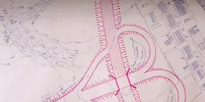
Out in the regions, things were already in motion. Lancashire County Council was keen to prepare for the future and, having already received permission, believed it was only waiting for funding before it could start work on its north-south motorway. In 1943 the Council drew up revised plans for the first section of the road, which was to be a bypass for Preston, running to the south and east of the town. Its layout and junction designs owed a great deal to the German Autobahn network.
The plan called for a whole range of free-flowing junctions - none of which appeared on the Preston Bypass as it was eventually built - including two cloverleaf junctions and one odd terminus that incorporated two loops instead of a normal trumpet interchange.
Because the Bypass scheme included a road across the south of Preston, linking to the A59 towards Liverpool, its course at the southern end was different, passing west of Walton-le-Dale and terminating on the A582 at Bamber Bridge, close to the junction of A6 and A49. At its northern end, designs were prepared for the short spur at Broughton to be continued to Blackpool, indicating that even then, Lancashire County Council was looking at a much wider plan for motorways than the Ministry of Transport was willing to authorise.
As with so many things, by the time the war had ended, much had changed and the carefully laid plans for road redevelopment needed re-evaluating yet again. It was time to go back to the drawing board.


