In 1938, a card game called Belisha was published to promote road safety. Its 52 cards pictured the sights of a journey across the UK. Where are they now?
It’s hard to imagine, but in the 1930s motor traffic was rather a novelty. Cars and lorries shared the roads with horses, while pedestrians would regularly step out and walk in the road as they pleased. Driving tests were yet to be introduced, meaning that many drivers were decidedly inexperienced by today’s standards and their behaviour was more unpredictable.

A gentle attempt to rein in the carnage came in the form of the Ministry of Transport’s “safety first” campaign, which hoped to encourage drivers to learn the Highway Code and take more care behind the wheel.
The campaign attracted a lot of public interest. Hopping on the bandwagon, “Belisha” was a widely-sold card game that replaced a traditional deck of cards with one using road signs, in the hope that people would learn their meanings while they played with friends.
Every card in the game is different, and the pictures on the card faces show landmarks you might see on a journey by road from London to Oban - though the choice of landmarks is often quite obscure, and you’d be taking a seriously scenic route if you passed them all.
Some of them are famous and unchanged: you’d recognise Buckingham Palace and Big Ben just as well today as in their 1930s paintings. Some are timeless like the many castles for which Belisha’s artist clearly had a taste.
Others are rather more intriguing, scenes from a lost world. We’ve had a go at finding some of the places the game depicts to see what’s become of them 85 years on.
Next week we’ll give you the chance to see the full set of cards, and even have a go at playing Belisha yourself.
A step back in time
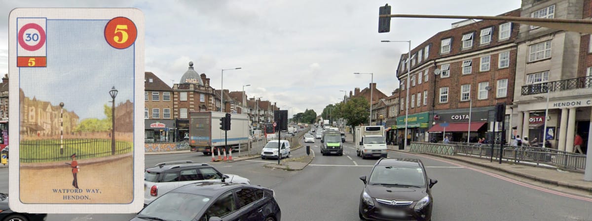
On the way out of London, the Belisha journey passes Watford Way in Hendon. The buildings in the background suggest we’re looking northwards at what was then a grassy roundabout at Hendon Circus, on what would have been a brand new arterial road. It’s now a major signalised junction on the busy A41.
Belisha also pays a visit to Apex Corner, the junction of A1 and A41 in Mill Hill. Now a grim signalised roundabout, there’s considerably more traffic in the way of a right turn towards the north.

This card claims to show the Pack Horse Bridge, Biggleswade. Some liberties have been taken with that description - the bridge still exists, now pedestrians only alongside a ford, but it’s actually in Sutton, just northeast of Biggleswade. If you passed through here on your way to Oban you’d be in for a slow drive on the back roads, but when it was built in the 13th century this was the main road north for packhorses.

Here’s a mystery. In the unassuming town of Sandy, Belisha’s artist stopped off to portray these thatched cottages on Ivel Road, a narrow cul-de-sac west of the main road. They appear to be completely gone today and Ivel Road is much like any other street.

Lying on the border of Bedfordshire and Cambridgeshire, the village of Eaton Socon is home to an odd little building called the Lock Up. Built in 1827, and intended to hold miscreants who were awaiting transfer to the magistrate in Bedford, it’s effectively a single cell jail. It’s located down School Lane, looking much the same today as in 1938, and would have once been visible from the Great North Road as you passed through.

This fine view of the Market Place in Grantham is unchanged today, save for the fact that the square has been partly pedestrianised, which civilises this pleasant public square but also means that this view from the north side of the market cross can only be seen on foot. The handsome building in the background is still there, now home to a shop where domestic appliances are serviced. The square is just off the Great North Road, but the weary traveller might have pulled in here for a break.

Barnby Moor isn’t on, or even very near, the A1. But that’s only because the A1 was rerouted in the early 1960s to use a new dual carriageway via Elkesley and Apleyhead, as part of the work to build the A1(M) Doncaster Bypass. Until then it passed through Retford before reaching the Bell Inn. It’s still there today, eminently recognisable, though now branded Ye Olde Bell Hotel and Restaurant, overlooking the junction of A634 and A638.

A famous stop-off for travellers for many years was at Skellow, north of Doncaster, where Belisha depicts Robin Hood’s Well and the classical gate lodges of Skelbrooke Hall. The well spring itself was capped when the A1 was upgraded to a dual carriageway, so it presumably lies somewhere under the tarmac, and the little structure sheltering it was moved a few hundred metres south. It now stands on this lay-by between Red House and Barnsdale Bar Interchanges, though it’s still visible to passing traffic on the A1 if you know where to look.

Robin Hood’s Well is lucky to survive; some of the places the game shows have gone entirely. This scene shows Marsh Road in Ferrybridge - a name and a road that have both vanished completely. Almost certainly this is looking south along the A1 towards the bridge from which Ferrybridge gets its name, but the modern dual carriageway A1 obliterated this road and everything around it. This is now the A162 between Ferrybridge and Brotherton, the A1 having shifted again to a newer motorway just to the west.

Entirely recognisable, by way of contrast, is this view of Wetherby, which is almost unchanged except for some intrusive vegetation. There’s been a bridge here, carrying the Great North Road, since the 13th century, but the current one dates from a partial reconstruction in the early 1800s. The A1 left town in the 1950s which means this is now a local road, but no less handsome for it.

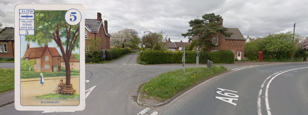
The Pack Horse Bridge at Sutton was a bit of a detour to see a historic landmark, but this diversion is positively inexplicable. Leaving the Great North Road to take in a length of the A61 in North Yorkshire, we have come to a stop in Baldersby, a nice enough little village, where the sight we’ve come to see is a small triangular green with a tree in the middle. The tree and peaceful bench are gone, replaced with a cluster of road signs, but the green is still there, and so is the little house with its diamond pattern brickwork.
The cards leave a bit of a gap until our next stop off, but presumably we go north to Scotch Corner, then across to Penrith on the A66, before finding ourselves at Gretna Green and a stop off that hasn’t changed a bit: the famous Blacksmith’s shop, site of countless weddings, which is perfectly recognisable today from its 1938 portrait. The road in front was once A6071, and is now B7076, but it would still be inadvisable to stand where this 1930s lady has chosen to loiter.

A final inexplicable detour brings us to Williamwath Bridge near Lockerbie, a nondescript iron crossing of the River Annan that carries a single track unclassified road towards Dalton. It is a listed structure, designed by David and Thomas Stevenson, sons of Robert Stevenson - though it remains a very obscure thing to go and see if you’re trying to get to Oban.

We’ll make one final call on our abridged journey with Belisha, which is to the statue of Robert Burns in Paisley’s Fountain Gardens. It’s still there, looking much the same, but one wonders why the artist chose to paint this very plain and austere statue when he could have turned around and painted the fabulously strange and ornate fountain standing next to it, complete with its four golden-bearded walruses.

If you’d like to see the full set of pictures, we’ll be posting the whole card game next week.
![]()
Comments
Is the game responsible for the term Belisha Beacons came from found adjacent to some 'zebra' pedestrian crossings?
No, it was named after them! Belisha Beacons came a few years earlier, and took their name from Leslie Hore-Belisha, who was the Minister of Transport responsible for introducing them.
As Chris5156 says, Belisha Beacons came in as part of the Road Traffic Act 1934. when Leslie Hore-Belisha was Minister of Transport. ' Originally unlit and also with no road "zebra stripes", the law under which the operate has remained unchanged since then. When I was a small boy, I distinctly remember going shopping with Grandma in Putney High Street, and being told "we must cross at the Belisha". To my absolute wonder, when we stopped by the Belisha to cross, the traffic stopped, and we were able to cross !
https://en.wikipedia.org/wiki/Belisha_beacon#History
The "Belisha" has been replaced with a signalised crossing now: -
https://www.google.co.uk/maps/@51.4632838,-0.21587,3a,75y,30.44h,75.59t…
Happy days !
A Book, recently reprinted. `Island Going` by Atkinson.
Its about his travels in search of the very shy Leaches Fork Tailed petrel.
But first he has to drive from London to Stornoway in a budget car, (£3 from the local scrap merchant)...
Its a book full of stirring adventure but I would have liked him to write more about motoring.
Add new comment
Picture credits
- Modern-day photography of each location is © 2023 Google.
Back in the 50s, my parents would take their family (3 boys) up to Scotland to visit my mother's parents in Greenock. After WW2 they had used the train, and also the overnight Starlight Special, (St Pancras to St Enochs, Glasgow). However, my father, ever cautious about money, decided it was best to use the overnight coach operated by Western SMT. This started from Victoria Coach Station around 8 pm, I think and went all the way up the Great North Road as it was in the 50s, to Scotch Corner, then the A66, to Penrith, then the A74 to Glasgow. I can't remember how many times we did this trip, but it was a LONG journey ! And when we got to Glasgow, we then had to get to Greenock ! Yet we lived in Tadley on the estate for the new Atomic Weapons Establishment at Aldermaston, so first had to get to Victoria Coach Station ! However, my father's parents lived in Putney, so via 2 Thames Valley Traction buses plus a London trolleybus we got to Putney and stayed overnight.
When you tell people of the kind of journeys one took to get anywhere in the 50s they find it difficult to believe you !