Until the 1970s you could drive the A625 across the Peak District. Then nature got involved. Now the road across the slopes of Mam Tor is accessible only on foot.
It's not far from Sheffield to Manchester, but between the two cities lies one of the highest and most challenging landscapes in England. The Peak District is just as its name suggests: high peaks and deep valleys, dales and moors, exposed plateaux and sheltered gorges.
Several roads offer a crossing of this picturesque wilderness, but none are modern or fast. There's the A628 Woodhead Pass, a trunk route and the closest thing to an all-weather crossing for heavy traffic (though still prone to closures in snow). There's the A57 Snake Pass, trickier and more exposed in bad weather. And until 1979 there was the A625, a more southerly route from Sheffield via Castleton to Chapel-en-le-Frith, from where the A6 completed the trip to Manchester.
West of Castleton is the Winnats Pass, a steep gorge, of which more later. A route around the north of it was created to take advantage of easier slopes along the east side of Mam Tor, one of the highest peaks in this area. It became the route of the A625.
The northerly route was longer and included sharper bends, but had a much gentler gradient. However, it also strayed off the bed of limestone that lies beneath Castleton and the Winnats Pass, and was carried instead on shale and other loose ground where it skirted the slopes of Mam Tor.
After decades of periodic closures, drastic repairs and attempts to stabilise one landslip after another, a decision was taken in 1979 that the road could not be maintained. It was closed to traffic permanently.
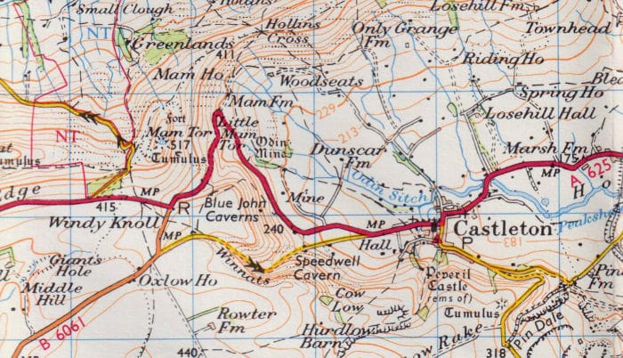
Until the early 2000s, the A625 still existed in two parts, with a gap at Mam Tor, marked on some maps as "no through route" as though it might one day re-open. That has now changed: the A625 has been rerouted far to the south; the road from Sheffield to Castleton is now A6187; and the former B6061 to the west has also been declassified. There is no through route except the Winnats Pass.
The closed road, and its surroundings, are stunningly beautiful and fascinating to explore. Let's take a tour of the abandoned section of A625, and then look at the remarkable Winnats Pass too.
The abandoned A625
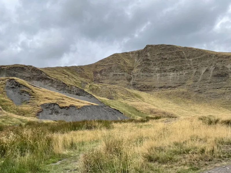
Rising up above the closed road is Mam Tor itself, a peak some 524m in height. The picture here doesn't really do it justice - though it's worth noting that, in the original photograph, there are people visible at the top, so tiny that they vanish completely in this compressed version.
Facing the camera is the slope that has been slipping away for decades, revealing layers of rock and other loose material that periodically breaks away and slips down towards the road.
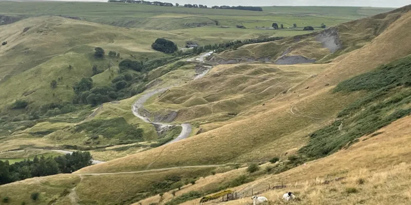
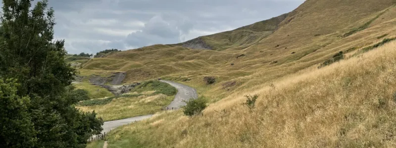
From the north you can take stock of the landscape. Mam Tor is on the right here, below which the ground is wrinkled like a blanket because it is moving and slipping downhill. The grey path snaking across the broken ground is what remains of the A625, its alignment now distorted where it has been pulled along by its unstable foundations.
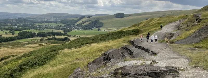
Stepping a little closer, the scale of the problem is evident. In the foreground is the hairpin bend that is visible on the map extract above. Beyond it, the road begins to slope upwards; at one time, it would have continued that gentle slope into the distance. Now it drops suddenly.
Looking back the other way from just beyond the hairpin, it's clear just how much the road has shifted down the hill here. In places there's very little of its original surface even visible.
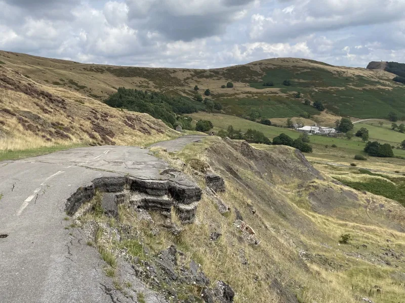
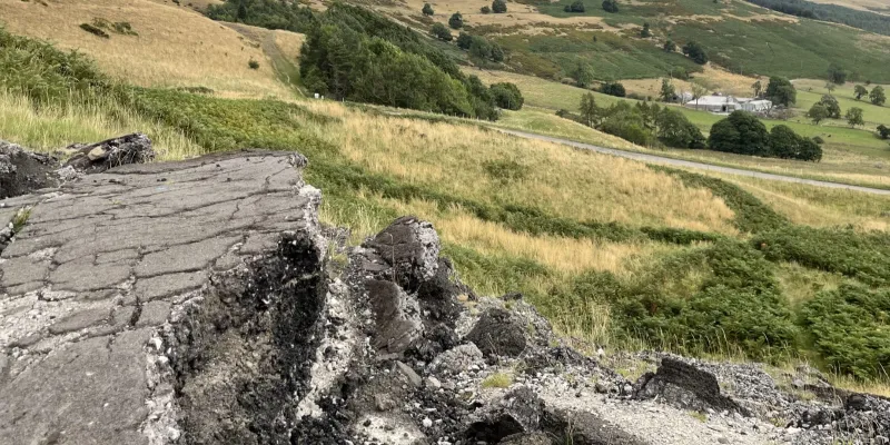
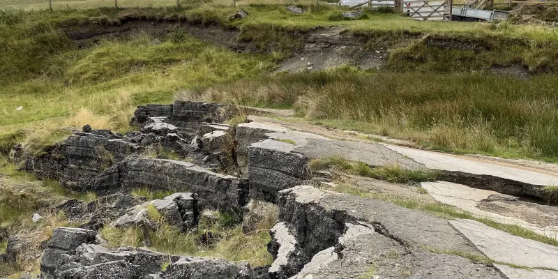
Beyond there the problem is even more obvious. A walk along the road becomes a scramble over broken boulders of tarmac.
As the road bed is pushed away and down the hill, it breaks up under its own weight. Below, in the distance, is a lower section of the former A625 - less troubled by the landslip, but still in need of regular repair because it's used to access Mam Farm.
Continuing west, there's another drastic change in height. Walkers have made an informal path around the side to avoid having to climb this two metre high wall.
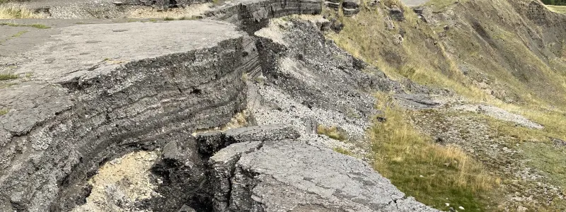
Where the road surface is breaking up, the layers of tarmac and concrete are exposed, looking rather like rock strata. A typical rural main road wouldn't have a surface this thick or made up of this many layers, though: what's visible here is a record of all the attempts to resurface and repair this road before the engineers finally gave up.
Another change in level creates this almost surreal cliff edge, where a seemingly driveable road suddenly ends in mid-air.
At the western end of the closure, the old road now forms a car park where walkers begin their ascent of the Peaks. The gate visible here is on the original road surface, illustrating again just how severe the shifts in level have been.
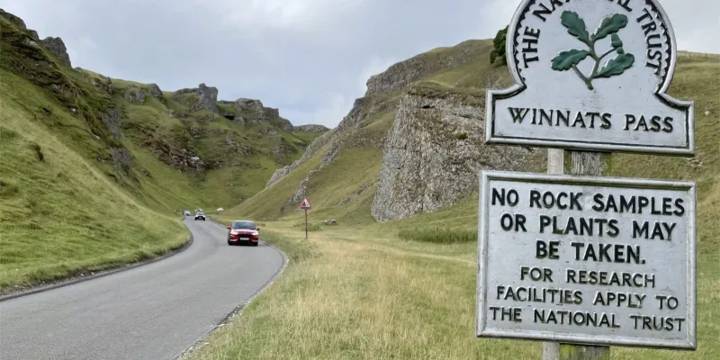
The closure of the route around Mam Tor didn't cut Castleton off from the west, nor did it completely close the through route towards Manchester. It did, however, force anyone wanting to travel that way through the Winnats Pass, which is owned by the National Trust and restricted to light traffic only. Today, the only way through is exceptionally beautiful and not especially easy to drive.
Through the Winnats Pass
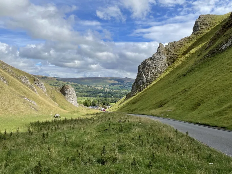
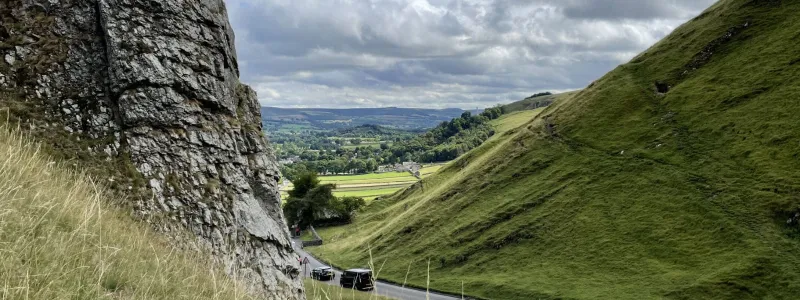
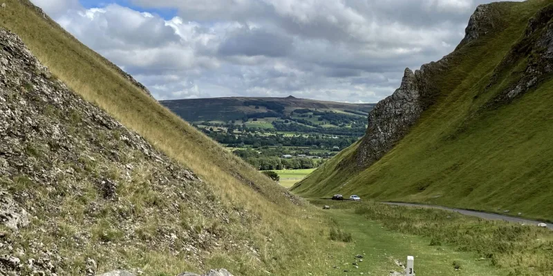
This is a mountain pass rather than a road through the hills - flanked by steep limestone cliffs, the road negotiates a steep climb in a narrow gorge.
The road leading to the pass from Castleton has been climbing steadily for some distance by the time it reaches a gate and cattle grid just beyond Speedwell Cavern. From here, it passes through unfenced moorland, where sheep graze and wander into the road, and is on National Trust land.
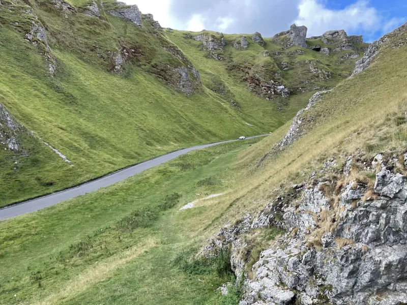
The pass itself is devastatingly beautiful as the narrow road curves through the rocks and grassy slopes. Tourists creep through, admiring the scenery and avoiding the sheep.
As the gorge winds through the hillside, different views open up. On an eastbound journey, the moment the valley is revealed, framed by the cliffs either side, is breathtaking.
Towards the top of the slope the road begins to emerge on the higher ground between Slitherstone Hill and Mam Tor. The journey is no issue in a modern car, but would be a tough climb in a lorry or coach, which is why every measure is used to discourage all but light traffic from traversing the Peaks this way. Even though this road remains open, the loss of the A625 has effectively closed this route for many vehicles.
Photographs can barely do justice to the scale and majesty of the landscape around Mam Tor and the Winnats Pass, nor can they adequately convey the joy to be had in visiting one of the pubs in Castleton afterwards. This is an amazing place.
More on Mam Tor
- Simon Davies' Rural Roads website visited the Winnats Pass in 2004, and called in to the abandoned A625 in summer 2005. His photographs of the abandoned road can be compared to the pictures above to see just how badly the road has deteriorated in seventeen years.
- The SABRE Wiki's articles on the A625 and its partial replacement A6187 go into more detail on the changes to the surrounding network that resulted from the road's closure.
- An archive news report from 1977 about the road reopening following extensive reconstruction work - just a couple of years before it had to close permanently.
Comments
I first visited Mam Tor in the late 70s with another chap, on motorcycles when I lived in Birmingham, and we climbed to the top. I then got married, but when we moved to Crewe, visited again, and my wife and I and her mother climbed to the top. Since then we've gone up or down the Winnats Pass several times, and have also visited the Blue John mine that lies off the old A625. Mam Tor is also called the "Shivering Mountain" due to its instability.
It is a wonderful place and not far from where I grew up! I'll have to get back there soon!
In a way, it is rather comical how nature prevailed over engineering but no doubt a fascinating case study.
The former B6061 from the A623 at Sparrowpit retains a degree of importance as the most straightforward route to Edale (the start of the Pennine Way) for coaches, though to make the reverse journey, it is probably easier to head to Chapel on the former A625 and down the A6 to pick up the A623 eastward. Or alternatively, get to Edale by train!
From a quick look at Google Streetview, the former A625 west of Castleton is incorrectly signed as the A6187 in places and as a route to Sheffield. Anyone following that who's not a confident driver would get a nasty shock on reaching the Winnats Pass! https://maps.app.goo.gl/J6fUeUBFZ84Fixpv9
It's not 'comical' at all. Nature will always prevail, however much mankind tries to control it and, in its attempts, eff it up.
Although a much shorter stretch, there is a similar closed road lost to landslip in East Sussex, grid ref TQ619316 (what3words: ///rummage.shifts.earmarked)
I saw a documentary about this road, and from what I recall the Ministry knew of the problems before WWII, and there are now problems with Snake Pass. I wonder if the M67 extension to Sheffield may have been stopped because of problems with the geology of this area?
I grew up close to here.
The Peak District is fine for that one day of summer, but far too cold and bleak for me now.
Some good motorbiking roads there though.
Cycled up and down this broken road, stunning scenery.
I remember this area well from a trip many years ago, not so much for Mam Tor itself, but rather for Winnats Pass. One snowy February morning on the way from Buxton to Castleton it was completely covered in fog (could not see much beyond 50ft) and blocked up. And so we diverted via Edale, and looked good while doing it thanks to AWD and winter tyres. Even with overcast weather, the afternoon drive back via Winnats Pass revealed some memorable scenery, and I have a small painting back home depicting it (minus the snow).
The A57 at Snake Pass is closed from today for approximately a month for road works linked to the subsidence problems.
Snake Pass has now reopened.
I saw an item on North West tonight yesterday about the Snake Pass. Derbyshire council are asking the government for more money to sort out the Snake Pass, or should I say the problem with landslips. They say that without the money the Snake Pass may well close.
Locally known as The Broken Road. My old boss ran a pub in the village for many years. Beautiful place.
I’m impressed that there remains a community of like minded Road obsessed ~interested individuals. Thank goodness for you or else I would be talking to myself. Which remains a possibility. In passing through, it strikes me that the picture of ‘layer upon layer of tarmac before the engineers finally gave up’ is reminiscent of The Grand Canyon rock layers albeit obviously on a smaller scale and tighter time frame.
Also, do you have any contacts within and/or information about the UK unadopted road fiasco?
Keep up the good work. TIA
Many years ago on my daily walk to work, new roads were being built for a commercial development that was never realised and one of the junctions was at a higher height to my path and I found it so interesting to see the change in the layers of the road from the great big builders on the bottom, each added layer being made of smaller and smaller chunks until the smooth Tarmac on top.
Yes, the climb up Winnats Pass is steep, with a posted gradient of 20%, but compared to the steepest road in the Peak District with a gradient of 36% it is not terrible. Although trucks and coaches over a certain MAM are prohibited, those up to 7.5 tonnes can attempt the climb. On my way down the pass one day, the traffic was moving very slowly and as I rounded the bend on the steepest section, I saw why. A 7.5 tonne truck was broken down on it's ascent. I stopped and asked if he would like to be towed to the top in order to clear the road, then turned my Land Rover round and pulled his truck up the hill. Low first made light work of the hill start and low second got us up the hill.
About 50 miles north of here there is another road with similar problems. Its the A59 at Kex Gill near Blubberhouses. I have heard of talk about closing the stretch of the A59 there and building a new stretch of road.
Stumbled across the abandoned road yesterday and was blown away - fantastic article and great pictures, thank you!
It may be in ruin but I always know a beautiful road when i see one, its a shame some of the greatest roads are so vulnerable, but its their location and their shape that makes them great i supose.
Rest in peace great road, how i wish me and my bike could have ridden you.
I walked up it on Saturday with a couple of friends who had never been there before. They were surprised at the extent of the subsidence. I last walked down in the 90’s. It appeared to be much worse now and certainly very different from before closure when I used to drive over it!





Winnats Pass is open to local buses, although these tend to go from the bottom as far as Speedwell Cavern only. However, there used to be a bus service running the full length of the pass until as recently as 2016!