View east from Brimmicroft footbridge to Riley Green 1, 17 July 1996

View east from Brimmicroft overbridge to Riley Green (see all photos of the same view)
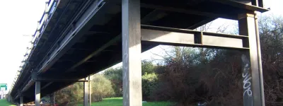
A base layer of the road surface has been laid all the way from the canal to Riley Green interchange. Across it, in the middle of the picture, one of the two spans of Brimmicroft bridge is now in place.
Structure 19a (Brimmicroft overbridge)
What's new
The road that made no sense
It was the UK's only single-carriageway motorway, and twenty years ago it ceased to exist. This is the story of the strange fascination it held, and of my place in history.
The forever bottleneck, part 2
The second part of the story, where we learn why exactly the M4 gets narrower on the final approach to Europe’s biggest city.
The forever bottleneck, part 1
The M4 into London was one of the UK's earliest and most ambitious motorway projects. It was bold, pioneering... and almost instantly regretted.
Have you seen...
Hogarth Flyover
It makes the traffic situation in one part of West London much more bearable but it should have been removed more than quarter of a century ago. It's amazing what you can do with a big Meccano kit.