View east from Hill House Farm to Sandy Lane, 12 December 1997

View east from Hill House Farm to Sandy Lane (see all photos of the same view)
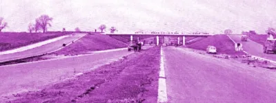
At the bottom left of the picture, the boundary fence for the motorway has moved to the bottom of the embankment. This cutting slope has been designed to be much shallower than is strictly necessary and its shape blends in to the natural slope of the land, with the intention that most of it would be returned to farmland. This helps the motorway fit in to its surroundings more naturally. Visible here are Hill House Farm bridge (in the foreground) and Sandy Lane (in the distance).
Structure 16 (Sandy Lane overbridge)
Structure 16a (Hill House Farm overbridge)
B5256 Sandy Lane
What's new
The road that made no sense
It was the UK's only single-carriageway motorway, and twenty years ago it ceased to exist. This is the story of the strange fascination it held, and of my place in history.
The forever bottleneck, part 2
The second part of the story, where we learn why exactly the M4 gets narrower on the final approach to Europe’s biggest city.
The forever bottleneck, part 1
The M4 into London was one of the UK's earliest and most ambitious motorway projects. It was bold, pioneering... and almost instantly regretted.
Have you seen...
A1(M) Darlington Bypass
Opened in May 1965, the A1(M) Darlington Bypass was one of the UK's earliest motorways and made huge strides in linking the North East to the rest of England. Explore the pioneering spirit of its engineers in the book they produced to mark its opening.