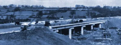
Sandy Lane overbridge, view west, 20 July 1995

Sandy Lane overbridge, view west (see all photos of the same view)
From this angle the foundation work for the bridge footing at Sandy Lane is clear, as is the depth of the new motorway cutting.
Structure 16 (Sandy Lane overbridge)
B5256 Sandy Lane
What's new
The road that made no sense
It was the UK's only single-carriageway motorway, and twenty years ago it ceased to exist. This is the story of the strange fascination it held, and of my place in history.
The forever bottleneck, part 2
The second part of the story, where we learn why exactly the M4 gets narrower on the final approach to Europe’s biggest city.
The forever bottleneck, part 1
The M4 into London was one of the UK's earliest and most ambitious motorway projects. It was bold, pioneering... and almost instantly regretted.
Have you seen...
M6 Preston Bypass
The "Preston By-Pass" was Britain's first motorway, opened in 1958. These books show the road as it was on opening day and share some of the thrill of this pioneering project.