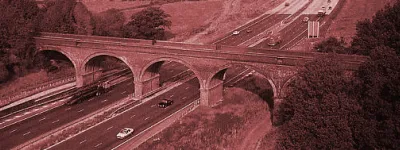
Great excitement surrounded the construction of the bypass around the south of Manchester city centre. While the cranes and concrete mixers were at work, the Manchester Evening News coined the phrase "highway in the sky" to describe it, and a local schoolboy won their competition to name the road. He chose the name "Mancunian Way".
Today it's a defining part of the city — both physically, as a very clear boundary of the city centre, and also culturally. Manchester took the "Manky Way" to its heart from the beginning, and it seems to be one of the few elevated roads in the UK that is accepted and tolerated by the majority of locals.
This tour focusses on the spaces underneath and around the motorway more than the road on top, giving a different view of a Manchester landmark and a unique road that thousands pass over every day without much thought.


Starting at the western end of the motorway, looking towards the underpass at the bottom end of Deansgate on the A56. The underpass here is more recent than most of the rest of the road, opening in the early 1990s.
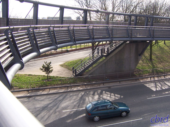
The footbridge here, linking the redeveloped Hulme to the city centre, replaces a dark and unpleasant pedestrian subway that used to stand on the same site.

Looking east from the same location, the start of the elevated section is visible, with sliproads to the A5103 Princess Road and the G-Mex exhibition centre. At the time these photos were taken, work was in progress to replace the crash barriers and parapets on the elevated viaduct, hence the roadworks visible here.

A first look from underneath the elevated road, standing in the middle of the Princess Road roundabout. The middle of both roundabouts are open to pedestrians, with subways from each approach road meeting there. This picture looks west again, to the end of the elevated section, with signs visible for Liverpool-bound traffic. Note the cobbles here: there will be plenty more before we're finished.

In the other direction, the A57 dual carriageway runs below the Mancunian Way to the next roundabout, curving away into the distance.

A closer look at the elevated road curving away. On the south side of the motorway are council flats. Few people would be prepared to buy a property this close to the road.

In the middle of the Cambridge Street roundabout is the plaque unveiled at the opening ceremony of the road. The grey stone has been brightened up with some jaunty squiggles of graffiti, and a sticker that reads "coming soon to this location: charming ruins". It was probably not put there by a fan of sixties architecture.

The eastbound sliproad from this double-roundabout system rises up to the top deck here, and the signage reflects the long-distance aspirations of the Mancunian Way's planners. You could reasonably expect, from this sign, to be able to reach these places by motorway, but you'd be sorely disappointed if you tried it.

A little way along, Oxford Road passes below the motorway. The Mancunian Way was conceived as a way to relieve the city centre of heavy goods traffic. At the time the road was planned in the late 1950s, Manchester was still a city of heavy industry. Today the elevated road is more of a commuter route, and I had to wait a long time to catch a lorry going over.

Peering through the railings on the east side of Oxford Road, the space underneath the road has been sold back to the University for use as a car park. This picture shows the entirety of the unfinished sliproad, peeling off to the left and stopping in mid-air.

This is the more famous view of the dead-end sliproad. In recent years a billboard has been erected in front of it to hide the city's shame, but there's only so much you can do to hide something like this. Especially when it points the wrong way up a one-way street.

The unfinished exit would have been part of the Brook Street junction, and this sign (now replaced with a larger one, placed on the unfinished sliproad itself) warns drivers of the eastbound exit that does exist: a tight loop to enter Brook Street southbound.

On exiting the sliproad forks immediately, and until very recently, these signs were the guidance at the split. They are original to the road — the top two from the road's opening, and the bottom one from a couple of years later when it was granted motorway status.

Brook Street interchange is in the middle of the University campus, and is littered with signs like this one: "No pedestrians on Mancunian Way". Presumably there is a long history of drunken students walking home along the elevated motorway.

In 2004 substantial work was carried out to landscape the space within the loops at Brook Street and make the pedestrian subways a little bit more appealing. Better lighting, well-kept grass and flowerbeds were put in place, and it has helped to brighten the place up a bit. There are still three levels of elevated concrete here, though, and that's quite hard to disguise.

There are also still epic quantities of cobbles — a sixties landscaping standby that are used to cover every slope and un-walkable surface here.

This is where the elevated section ends, and on the south side of the viaduct at Brook Street, the road's Concrete Society Award is proudly displayed. It is rather cleverly made out of several different types of concrete.

The other loop, on the south side of the motorway, has a better alignment with a smooth, continuous curve, and no strange junctions part way around it. It's slightly elevated above ground level on retaining walls.

The loop is used to enter the motorway westbound, and stops rather suddenly at a give-way line. Good luck!

Looking eastwards across the sliproad, the final junction can be seen in the distance — the flyover at Downing Street. It is, again, more recent than the main elevated section, and opened in about 1992.

The Downing Street flyover itself — a more slim and graceful structure than the sixties elevated road. Underneath is a very large signalised junction where the A6 and A57 meet the sliproads from the motorway. To the east of this point the road is no longer a motorway, though it is still named Mancunian Way until the next junction along.

The sterilised land underneath the motorway has, in this location, been put to use as a skate park.

More long-distance destinations are signposted along the Mancunian Way, though once again it's impossible to reach any of them from here by motorway alone!

A more legible plaque is mounted on one of the flyover's pillars, commemorating its opening. Unlike the easily vandalised one at Cambridge Street, this one is mounted high up and out of reach.

One final look back at the motorway from underneath, with the westbound on-slip rising slightly to join the motorway back towards Hulme.
With thanks to Kirk Northrop for information on this page.