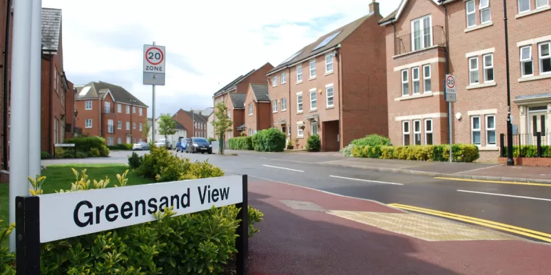
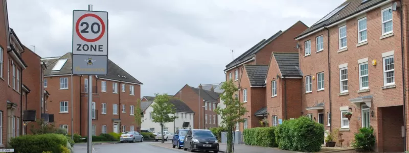
The sign says you're entering Beesworth. But you can't be - there's no such place. What's going on?
Let's go back a step. We're in Woburn Sands, a village in Buckinghamshire just to the south of Milton Keynes. It's nice here. There's a high street full of interesting shops, an old-fashioned railway station on the Marston Vale line and some pleasant countryside round about.
If you like the look of Woburn Sands, you could move here, if you want. Taylor Wimpey are putting the finishing touches to a large new housing development on the northern edge of the village, just next to the station. Handy for commuting. The new estate is laid out as a series of peaceful little streets and cul-de-sacs, and as you enter it from the main road, you'll enter a 20mph zone.
The "20 zone" signs have a little panel at the bottom that announces the name of this area as "Beesworth". And that is such a novelty that Darren Sibley spotted them, photographed them, and shared them with the SABRE Facebook group, where they caught our attention.
Ceci n'est pas une Beesworth
That brings us back to where we started, because this isn't Beesworth. There's no such place as Beesworth. It doesn't exist. Try a search on your favourite online mapping tool. Try, if you like, the Ordnance Survey Gazetteer. You won't find it, because there is no such place as Beesworth.

The question, then, is why it's on the sign. And the answer is in some legal paperwork called the Traffic Signs Regulations and General Directions, TSRGD to its friends, which sets out the appearance of road signs. If you have a copy to hand, you may wish to turn to Schedule 10, Part 2, Item 5, which is diagram 674, "entrance to a zone where a maximum speed limit of 20 mph is in force".
Or, if you'd rather, the same diagram is in the Highway Code. You'll have seen it before: it's the regular "20 zone" sign that usually has a panel at the bottom with the name of the village in it, or sometimes a child's drawing of a speeding car or the slogan "twenty's plenty". The one in the regulations, though, doesn't say "twenty's plenty". It looks like this.

What you have in Woburn Sands, then, is not a housing estate called Beesworth. The "20 zone" signs on Greensand View are the exact ones specified in the regulations, complete with the clip art graphic and dummy place name that are used as an example to show what the lower panel might contain. Whoever put them up appears to have been under the impression that a picture of a bee and the made-up word "Beesworth" are necessary to make a 20mph zone legally enforceable.
In other words, this is a mistake, and a really silly one at that.
What does this mean?
There are three lessons we can take away from this.
First, the 20 zone on Greensand View is still entirely legitimate and enforceable. The regulations say that the bottom panel may be changed in all sorts of ways without invalidating the sign, but the sign is perfectly valid on its own. The fact that it has a meaningless picture of a bee and a made-up town on it doesn't change that.
Second, the 20 zone sign is one of the very rare road signs that is never meant to be used for real without being modified. The actual, official diagram that appears in the regulations is never what you will see on the road. Except here. Woburn Sands might have the only plain vanilla 20 zone in the UK.
And third, the skills shortage in highway engineering, and the marginalisation of road sign design within highway engineering that is one of the results of that skills shortage, are very real. These signs were designed, manufactured, quality checked and erected by people in paid jobs in the highways sector who looked at them and saw nothing wrong. And that's a bit worrying, isn't it?
Sooner or later - we hope - someone will be along to put this right. And until then, if you want to see Beesworth for yourself, head for Woburn Sands, because you won't find it mentioned on the signs.
Well, not on most of them, anyway.
Comments
By any slim chance, maybe this is deliberate so as to attract some attention?
Another question of remote relevance: I remember that in Hong Kong road signs were at one time manufactured in prisons. Does the UK apply this practice now?
A new housing estate near me had blue 30 signs at the entrance. You had to go at least 30 mph through there. Or someone just liked the blue versions better :-)
It's probably actually easier to just rename the estate Beesworth. After all the people who manufactured and installed the signs think it's called that.
Beesworth Estate, twinned with Nid Wyf yn y Swyddfa Industrial Park in South Wales.
If you were involved in a crime and told the police you were in Beesworth at the time...…… They might have a problem disproving it.
Having worked on the technical side of the manufacturing industry for 10 years, I can say this kind of thing is par for the course with many recent graduates from our wonderful British universities. It's the number one reason so many UK-based companies, particularly multinationals, end up outsourcing their technical services to the continent.
Or a lack of competency at the top, Terry. It would have been checked multiple times in house and approved by the planning authority, not just plonked willy-nilly.
@Terry Trumpets Nonsense, that's all about money
This would be very funny if it wasn't so pathetic! Perhaps it is a good job the Handbook version of the sign doesn't say something like "Insert Name Of Street Here" or that would have been faithfully reproduced!
Maybe, in time to come, "Beesworth", Woburn Sands will become a real place, and be found on the Census in 100 years' time! The only problem is, the historians then might have a problem working out the origin of the place name!
There is the famous case of the Welsh local authority who wanted a bilingual sign advising delivery lorries where to go at a supermarket. When the reply came back, they had the signs made up to include the Welsh text in the reply. Unfortunately, what the rpley actually said in Welsh was: “I am not in the office at the moment. Please send any work to be translated”.
I've just been reading up about "Trap streets", which are inserted on commercial maps to help prevent copyright infringements - they work too, with the AA having to pay the Ordnance Survey about £20M when they were caught copying their mapping.
There are also "Trap towns", such as Agloe, New York state, again put at a road intersection to catch the plagiarists. What then happened is that someone who used the map with Agloe on it built a general store at the intersection and called it the Agloe General Store, thus creating in reality the place that had only previously existed as a fiction. Other mapmakers then started including Agloe on their mapping. The original mapmaker tried sueing, but lost since the facts on the ground had now changed.
This "Beesworth" is perhaps a little like Agloe, though without ever existing on a map before. How long before the name is adopted by the estate and really appears on the map after all?
FWIW, there are some completely generic 20 zones around, minus any customisation at all: this is Rushenden on the Isle of Sheppey.
Ask and thou shalt receive. There is a place called Beesworth. The signs on the ground say it, it can be seen with your own eyes, and it seems that Openstreetmap.org has that estate in Woburn Sands named as Beesworth, with the signs stated as the source of the name.
Anyone can edit OpenStreetMap though. Like Wikipedia.
Hillarious. I just found this after seeing the sign in the guide and Googling Beesworth. So maybe it's time to right-click on the map in Google Maps and add it. When they ask for proof, just supply a link back to the Street View where the sign is clearly visible.
I'm typing this comment in Woburn Sands, and can report that these signs have now been replaced with signs that do not include the Beesworth panel. So the estate isn't called Beesworth after all!


I'm looking forward to the new Puddleworth Services. I'll enjoy eating a burger in Good Food.