First conceived in the 1940s as a replacement for a road barely twenty years old, the M12 would have provided a fast route from London out towards Essex. It was never built but lingered, as an idea, through to the 1980s.
Discussing the M12 is tricky because at different times there have been several road proposals that carried that number, all overlapping in purpose and location.
The first M12 proposal - and the one this page is principally about - would have replaced the A12 between the Ringway 2 North Circular Road at Woodford and Ringway 3 (now the M25) at Brentwood. It was a simple bypass for the congested A12 Eastern Avenue.
In the early 1970s, while the first M12 was still plodding through the formalities of the Greater London Development Plan Inquiry, a second idea popped up, connected to proposals for a major new international hub airport at Maplin Sands off the Essex coast. To link the airport to London, an extended M12 was proposed from Brentwood, past Southend and out to Maplin. That concept was separate to the Ringways, but was tacked on to the original proposal.

The third M12, conceived long after the first two had fallen by the wayside, was a 1980s proposal to replace the congested A12 between the M25 and Chelmsford. It would have provided a new, faster way between those points and led on to the brand-new Chelmsford Bypass, but was abandoned in favour of cheaper proposals to widen the existing A12 - work that never really started. It's not described here.
Of all London's unbuilt motorways, the collapse of the original M12 project is one of the hardest to understand. It offered stellar economic returns, was completely justifiable as a project on its own, and depended on no other motorway proposal in order to be useful. Yet it still faltered when other London motorways were scrapped, and despite its route remaining free from development, has never been re-examined since its cancellation in the mid-1970s. It will, now, never be built.
Outline itinerary
![]() Continues as A12 to Chelmsford and Colchester
Continues as A12 to Chelmsford and Colchester![]() Ringway 3 Eastern Section (Brentwood Interchange)
Ringway 3 Eastern Section (Brentwood Interchange)![]() Noak Hill Road (Noak Hill Interchange)
Noak Hill Road (Noak Hill Interchange)![]() A1112 Romford Road (Whalebone Lane Interchange)
A1112 Romford Road (Whalebone Lane Interchange)![]() A123 Fencepiece Road (Fairlop Interchange)
A123 Fencepiece Road (Fairlop Interchange)![]() Ringway 2 North Circular Road, Eastern Section and M11 (Woodford Interchange)
Ringway 2 North Circular Road, Eastern Section and M11 (Woodford Interchange)
Cost summary
| Property acquisition (1970) | £1,000,000 |
| Construction (1970) | £14,750,000 |
| Environmental works (1970) | £420,000 |
| Total cost at 1970 prices | £16,170,000 |
| Estimated equivalent at 2014 prices Based on RPI and property price inflation | £42,618,802 |
See the full costs of all Ringways schemes on the Cost Estimates page.
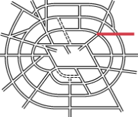
Route map
Scroll this map horizontally to see the whole route

Key to map symbols
| "Primary Road" Network | |
|---|---|
| Primary Road | |
| Primary Road section in tunnel | |
| Primary Road approximate or assumed line | |
| Primary Road cancelled or deleted before start of GLDP Inquiry | |
| "Secondary Road" Network | |
| Secondary Road single carriageway or of unknown formation | |
| Secondary Road known to be dual carriageway | |
| Secondary Road section in tunnel | |
| Junctions | |
| Location of Primary Road junction where layout is not known | |
| Location of Secondary Road junction where layout is not known | |
| Location of a junction cancelled or deleted before start of GLDP Inquiry where layout is not known | |
Route description
This description begins at the western end of the route and travels east.
Woodford to Brentwood
The M12 would begin at Woodford Interchange, a sprawling junction in north-east London that would link it to the M11 and Ringway 2. Some of the bridges carrying the M11 through this area were designed to accommodate the M12, most notably a six-span viaduct carrying the southbound M11 that would have crossed the mainline of the M12 and two sliproads.
The motorway would travel east through a gap in the suburbs, crossing Roding Lane North by the garden centre and travelling through the southern edge of Claybury Park. The motorway would meet the A123 Fencepiece Road at a roundabout interchange, with the M12 passing beneath. The urban 50mph limit would end here, and from this point onwards the motorway would be designed to rural standards and subject to the National Speed Limit.

The route continues east across the Central Line just north of Fairlop Station and crosses Forest Road at a skew. A second local interchange would connect to the A1112 Whalebone Lane near its junction with the B174 Romford Road. This would be another roundabout interchange, with the M12 passing beneath, but here the design would allow for a future north-south flyover carrying the A1112, catering for proposals to build a Secondary Road through what became known as the Dagenham Corridor.
Turning north east, the motorway would skirt Willoughby's Hill and pass just to the north of Havering-atte-Bower. A service area would be provided here, in line with the Ministry's policy of providing one about twelve miles from Charing Cross on all radial motorways.
A final local junction would be provided at Noak Hill, with a short spur leading to Noak Hill Road. In early plans this junction provided access in all directions, before being revised to only have sliproads to and from London. The settled design in 1972 called for the third lane to end here, and east from this point the M12 would have only two lanes in each direction.

Crossing Noak Hill Road and turning gradually to the south east, the motorway would cross the Ringway 3 Eastern Section at a large interchange incorporating the A12 and A1023 - a three-level stacked roundabout junction with additional free-flowing sliproads, quite different to M25 junction 28 which now occupies this site. It would terminate by merging in to the A12 Brentwood Bypass.
The stolen radial route
Built between 1921 and 1925, Eastern Avenue - originally A106, now part of the A12 - was the pride of London's inter-war Arterial Roads Programme. A broad avenue conveyed the motorist from the Green Man at Leytonstone out across open country, bypassing the congested A12 through Ilford, Goodmayes and Romford, and on to Gallows Corner at Gidea Park. There it returned traffic to the A12 towards Chelmsford, and allowed access to the equally new and thrilling A127 Southend Arterial Road.
Unfortunately, Eastern Avenue suffered more than most from the problem of "ribbon development", the construction of houses along roads through what was otherwise countryside, and a sure-fire way to make a fast interurban road slower.

By the 1940s, Eastern Avenue was not yet 20 years old, but it was already hopelessly slow and congested, suffering the blight of suburban traffic and low speed limits because development had carelessly been allowed along its entire length. When Sir Patrick Abercrombie came to write his Greater London Plan in 1944, setting out a vision for the metropolis, he didn't consider a single inch of it fit for purpose, and remarkably proposed to replace this brand new road wholesale with a bypass that he called Radial Route 7.
Abercrombie's plans for a coherent road network persisted in the Ministry of Transport's thinking for decades, and by the 1960s, Radial Route 7 was still being held in reserve as a possible idea. The innermost part, providing a new route alongside the Central Line from Hackney to the Green Man, was an urgent priority.

In 1964, though, it was suddenly and unexpectedly amputated. The MOT had decided to re-route the M11 from its original home in the Lea Valley to a new course down the Roding Valley, which would mean it entered London at Woodford. To get to its planned terminus at Hackney, it would then take over the course of Radial Route 7 to Hackney.
From that date, Radial Route 7 ran only from Woodford to Brentwood, and was firmly on the back burner. Its most urgently-needed segment was gone. And for the rest, the Ministry had firm plans to improve the existing A12 Eastern Avenue - so there would be no need for a grand bypass around the north of Romford any time soon, would there?
Fixing the A12 by not fixing the A12
The Ministry's plan, in the early 1960s, was to improve Eastern Avenue to remedy the effects of all those 1930s semi-detached houses alongside it and turn it back into the high speed approach to London that it was supposed to be. The result would have looked something like the modern A3 Kingston Bypass, another 1920s road blighted by 1930s ribbon development and "fixed" in the sixties by slicing off front gardens to make way for underpasses and flyovers.

For most of Eastern Avenue, that was achievable. The sticking point was Gants Hill, a small and decidedly awkward six-way roundabout with an Underground station in the middle, located at a busy local shopping centre and the point where a branch of the North Circular Road terminated on the A12. Plans were drafted for a clever - but horrifyingly intrusive - three-way, double-deck flyover, which would deal with the traffic. But it would be hugely detrimental to the surrounding area, and with everyone agreed that it wasn't quite the right answer, a study was commissioned to see what could be done about it.
The study reported back in 1965 with the clear-cut finding that Gants Hill was an utterly intractable problem, and that it would be better to forget about improving Eastern Avenue at all and instead just build Radial Route 7 to bypass it. It would, in fact, cost £8m to reconstruct Gants Hill with a complex and ugly double-deck three-way flyover, leaving the rest of the A12 still to be fixed, while the whole of Radial Route 7 from Woodford to Brentwood could be built as a motorway for a similar amount.
There was simply no competition. On 21 October 1965, a press release was issued announcing the appointment of a firm of consulting engineers to produce designs for the new bypass.
Design work proceeded at a rapid pace. Early plans included a lengthy spur to Gallows Corner, linking it to the A127 Southend Arterial Road, but that was quickly abandoned because Ringway 3, connecting to the route's eastern end, would provide the same service.

In March 1969, a decision was communicated across the Ministry that the name Radial Route 7 could be dispensed with. The project had a new name: the M12 Motorway.
In economic assessments, the motorway performed unusually well, offering significant returns on the investment even in the first year. The relief offered to the A12, the subsequent improvement in quality of life for those living nearby, and its increased availability for local journeys, were considered huge benefits.
By January 1972, the Department of the Environment (successors to the MOT) had made up their mind. The Eastern Road Construction Unit were instructed to draw up construction plans, legal orders and contract tenders. The only thing preventing them from being issued, and work beginning, was the Greater London Development Plan Inquiry, which was still ongoing.
The DoE, and their consultants, were sure that the M12 was a worthwhile project in its own right, and that while it contributed to the vision of a motorway network for London, it also worked perfectly well on its own. They were in no doubt that they wanted to get on and build it. But the planning process disagreed: it was a motorway in London, it featured in the draft Greater London Development Plan, and it must wait out the Inquiry.

The Inquiry, of course, rejected wholesale the concept of a dense motorway network for London and demanded the scaling back of road plans across the city. The GLC's new administration, elected in the midst of a public outcry over urban motorway construction, no longer supported the building of new motorways in Greater London.
In 1976, the Greater London Development Plan was finally published, stripped of many roads, yet the M12 persisted as a "road under consideration". It never recovered from the uncertainty, though, and soon become just another road that wouldn't be built.
Without it, the M11-M25 junction was reshaped so traffic could avoid Eastern Avenue by travelling far to the north via Epping. The A12 remains slow and congested.
Picture credits
- Route map contains OS data © Crown copyright and database rights (2017) used under the terms of the Open Government Licence.
- Photograph of view from A1112 and traffic on A12 are taken from originals by Marathon and used under this Creative Commons licence.
- Photograph of Gants Hill in 1964 and artist's impression of Gants Hill flyover are extracted from HLG 136/195.
- Plan of Radial Route 7 is from Greater London Plan (1944), Patrick Abercrombie, HMSO.
- Plan showing M12 route to Gallows Corner is extracted from HLG 131/284.
Sources
- Route, R2-R3; spur to Gallows Corner present in early version of plans; change of name to M12: MT 106/280.
- Variant extending M12 to Maplin: AT 56/98.
- 1980s plan for M12 M25-Chelmsford: period DTp planning map available at Pathetic Motorways.
- Eastern Avenue built as part of Arterial Road Programme: MT 39/511.
- Abercrombie proposal for RR7 to bypass A12 to north: County of London Plan (1943), JH Forshaw and Patrick Abercrombie, Macmillan; Greater London Plan (1944), Patrick Abercrombie, HMSO.
- Study recommends building RR7 instead of improving A12; cost comparison; positive economic assessment of scheme: MT 106/281, MT 106/454; HLG 136/195; HLG 131/284.
- Legal orders drawn up in 1972: MT 106/454.
