The northern side of Ringway 3 would run mostly through open country and presented few problems - that's why almost all of it exists today. In fact it was a struggle not to build the part that's missing.
The division of Ringway 3 into four sections for the purpose of describing it in these pages is entirely arbitrary. Ringway 3 was a complete ring road that was split into any number of individual and overlapping parts at various times. The "Northern Section" is really just a convenient quarter of it: the part that would have run from the M1 in the north west to the Ringway 4 North Orbital Road in the north east.
The whole of this length was originally planned to be part of the M16, the number by which Ringway 3 would be known to the public. (Compare this with M15, allocated to a small section of Ringway 2, and M14, which was reserved for Ringway 1's West Cross Route.) It opened in stages from 1975 onwards, but its first section opened as the A1178. Motorway status and a motorway number were going to follow later. By the time it got its blue signs, the M16 and the Ringways were gone, and it became part of the M25.
Outline itinerary
![]() Continues from R3 Western Section
Continues from R3 Western Section
![]() M1 (Bushey Interchange)
M1 (Bushey Interchange)
![]() A1 and A1(M) (South Mimms Interchange)
A1 and A1(M) (South Mimms Interchange)
![]() A111 Southgate Road (Potters Bar Interchange)
A111 Southgate Road (Potters Bar Interchange)
![]() A10 (Waltham Cross Interchange)
A10 (Waltham Cross Interchange)
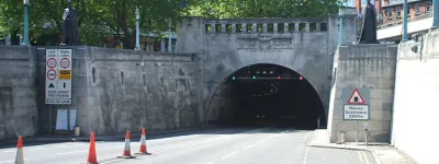
![]() Holmesdale Tunnel
Holmesdale Tunnel
![]() A121 Honey Lane (Waltham Abbey Interchange)
A121 Honey Lane (Waltham Abbey Interchange)
![]() A11 Epping High Road (Bell Common Interchange)
A11 Epping High Road (Bell Common Interchange)
![]() Bell Common Tunnel
Bell Common Tunnel
![]() M11 (Theydon Interchange)
M11 (Theydon Interchange)
![]() R4 North Orbital Road
R4 North Orbital Road
![]() Continues to R3 Eastern Section
Continues to R3 Eastern Section
Cost summary
| Property acquisition (1970) | £7,970,000 |
| Construction (1970) | £66,286,000 |
| Total cost at 1970 prices | £74,256,000 |
| Estimated equivalent at 2014 prices Based on RPI and property price inflation |
£339,671,031 |
See the full costs of all Ringways schemes on the Cost Estimates page.
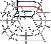
Route map
Scroll this map horizontally to see the whole route

Key to map symbols
| "Primary Road" Network | |
|---|---|
| Primary Road | |
| Primary Road section in tunnel | |
| Primary Road approximate or assumed line | |
| Primary Road cancelled or deleted before start of GLDP Inquiry | |
| "Secondary Road" Network | |
| Secondary Road single carriageway or of unknown formation | |
| Secondary Road known to be dual carriageway | |
| Secondary Road section in tunnel | |
| Junctions | |
| Location of Primary Road junction where layout is not known | |
| Location of Secondary Road junction where layout is not known | |
| Location of a junction cancelled or deleted before start of GLDP Inquiry where layout is not known | |
Route description
This route description starts at the western end of the route and travels east.
Bushey to South Mimms
Ringway 3 would meet the M1 at an interchange close to Bushey, between junctions 4 and 5, near Hilfield Park Reservoir and Elstree aerodrome. Only turns between the north and west would be catered for at the M1 interchange, though traffic on Ringway 3 would also have access to the A41.
Parts of this interchange actually exist. The bridge carrying the A41 North Western Avenue over the M1 just to the north of this point was future-proofed, at the time of its construction in 1967, with space on top for the A41 to be upgraded to dual carriageway and an extra span underneath that would accommodate an exit sliproad from the M1 southbound towards what was still, at that time, the "D" Ring Road. The extra span, on the east side of the motorway, now carries a public footpath. On the northbound M1, a particularly large police lay-by just south of the A41 bridge is actually a stub of sliproad, intended to be the point where traffic from Ringway 3 would join.

The Northern Section would travel north-east from this junction, continuing from the Western Section, and skirting the fringes of Borehamwood. After crossing the B5378 Green Street, the motorway would run in a more or less straight line across the A1, joining the modern M25 at the point just east of junction 23 where there is a wide gap between the carriageways.
The intended final layout of South Mimms Interchange called for two spur roads from Ringway 3 to the large roundabout, one to the east and one to the west. The east-facing spur road is now the mainline of the M25 across the interchange, and the gap in the carriageways a tell-tale sign that it was supposed to form a pair of sliproads, merging in to a motorway that isn't there.
South Mimms to Navestock
From South Mimms onward, Ringway 3 is the M25 as it exists today - though, of course, it was planned and built as a dual three-lane motorway with hard shoulders, not the four-lane Smart Motorway that now exists.

A local interchange at Potters Bar is followed by a roundabout interchange with the A10, one of the main northern radial routes in the Greater London Council Primary Road network. A short cut-and-cover tunnel then carries the motorway through a residential area, where a gap between the houses was intended for the relatively genteel "D" Ring Road, and not for a thundering motorway. By putting the road underground, it was possible to use the full available width without disturbing the residents who would otherwise have had to overlook it.
The next local interchange at Waltham Abbey, now M25 junction 26, would be followed by a pair of east-facing sliproads connecting to what was then the A11 through Epping Forest. These appear to have been designed to allow the M11 and Ringway 3 to form a bypass of Epping. That road is now the B1393, and the junction was never built. A second cut-and-cover tunnel under the cricket pitch at Bell Common brings the motorway to Theydon Interchange and the M11. The present junction has a symmetrical four-way layout, but the original plans omitted turns between the south and east - movements that would have been made pointless by the M12. When the M12 project stalled, a decision was presumably made to redesign the junction in its present form.

Finally, about halfway between present-day junctions 27 (for the M11) and 28 (for the A12), close to the village of Navestock, the Ringway 4 North Orbital Road would have arrived from the north, combining with Ringway 3 to form one single orbital route southwards to the Thames - the Ringway 3 Eastern Section.
Trunk Road 115
One reason that so much of the Northern Section exists is that it had a head start. Years before the GLC coined the term "Ringway", the Ministry of Transport were planning the "D" Ring Road, one of Abercrombie's five rings. In the late 1940s a decision was taken that only the north and west sides of the ring were needed in the foreseeable future, running from the new "Basingstoke Radial" (M3) to the A11, making a third of a circuit.
The Ministry of Transport approved the "D" Ring as a trunk road project, and in those days, a trunk road needed both a number and a name. The number was easy - Trunk Road 115 - but the name was more difficult. Ideas considered in 1959 included "The Greater London Northern Ring Road", "The North Inner Radial Road" (an interesting choice for a road that wasn't in any sense an inner radial), and the positively inscrutable "Second Lateral". The eventual choice was a little more prosaic: "TR115 Sunbury - Harrow - South Mimms - Waltham Abbey (London D. Ring) Trunk Road". Work began to make it a reality.

It would borrow sections of existing road, improved where necessary, linking them with new lengths. Across north London, the section from the A1 to the A10 was going to be entirely new, and the present M25 essentially runs on the alignment chosen in the 1950s with some minor adjustments. Look on a map, though, and it's obvious that the straight line formed by that section ends with a noticeable curve to the north east at Waltham Abbey, and the M25 then loops around the north of Epping Forest. That curve is a later invention; at Waltham Abbey the "D" Ring would have joined the existing A121 Honey Lane for a short run across to the A11.
Ambitions in those days were modest. The section linking the A1 to A10 was the most urgently needed, and it was programmed for construction in the 1962-63 financial year as a single carriageway, but was repeatedly delayed in favour of other projects. As late as 1965 the Ministry were undecided whether to build a dual or single carriageway road. By 1966, the GLC were pressing the Ministry to build a motorway, but the plan was still for an all-purpose road with two lanes each way, though with space for later widening.
It was only following continued pressure that the Ministry agreed to build a three-lane road to motorway standards, though they were adamant that it was going to open as an A-road. Minutes of planning meetings between 1966 and 1968 show the GLC's representatives persistently asking whether the road would be a motorway, and if it would have three lanes each way, to the growing irritation of the Whitehall civil servants.
By May 1968, the Ministry had evidently given in, and received Treasury approval to build Ringway 3 as a motorway. Legal advice confirmed that the earliest sections could open as an A-road - because it was too late to change them - and be reclassified as a motorway later.

Planning during the 1950s on a very different road scheme are the reason why the first section of Ringway 3 was from the A1 to Potters Bar in 1975, and why it opened as an A-road, the A1178. But while the project itself was much older than the Ringways, it's lucky that the type of road changed with the times - otherwise the first section of the M25 might have been a two-lane dual carriageway with a wide central reservation.
Hitting the brakes
The unbuilt part of the Northern Section runs from the M1 at Bushey to the A1 at South Mimms. In 1973, it was getting very close to construction - even though the Western Section, without which it made little sense, had no fixed route.
1973 was the year of the Layfield Report. As soon as the Government accepted its recommendations, they were committed to building a single outer orbital motorway, made - as Layfield suggested - from whichever bits of Ringway 3 and Ringway 4 were furthest advanced or easiest to build. It was immediately obvious that joining Ringway 4 at Hunton Bridge to Ringway 3 at South Mimms required an entirely new motorway line. Ringway 3 between the M1 and A1 would, therefore, no longer be required.
The first job, then, was to cancel it. That was easier said than done.

The M1-to-A1 project was already in the trunk road preparation pool, meaning legal orders were being prepared, compulsory purchases lined up and contracts drafted. Worse, worried-sounding civil servants described the project as an "accelerated" scheme, meaning that other projects had been pushed aside so that this one could power through the planning process at full steam. Money had been spent. Commitments had been made.
The implication - judging by the sturdy wedge of paperwork that was generated simply by the administrative process of cancelling this short section of motorway - is that applying the brakes like this was an unprecedented move. Unlike other schemes that were shelved or outright cancelled when the Ringways fell from favour, this was a live project, and one rapidly approaching the point where shovels would hit the ground.
In the end, the Minister, Geoffrey Rippon, was asked to sign off the decision, and in doing so, he accepted responsibility for ending a project that had already cost an awful lot of time and money. It was an embarrassment, for sure, to make such a u-turn - but less embarrassing than if we'd ended up with a useless stub of motorway splitting off the modern M25 at South Mimms and terminating on the A41 near Bushey, which is all it would have ever done.
Empty space
While civil servants battled to derail the M1-A1 section of Ringway 3, shovels actually were hitting the ground on the next section to the east, the length from the A1 to the A10. It's now part of the M25, but it was designed to be part of Ringway 3, and that's why it includes a large gap between the carriageways, just east of M25 junction 23 at South Mimms.
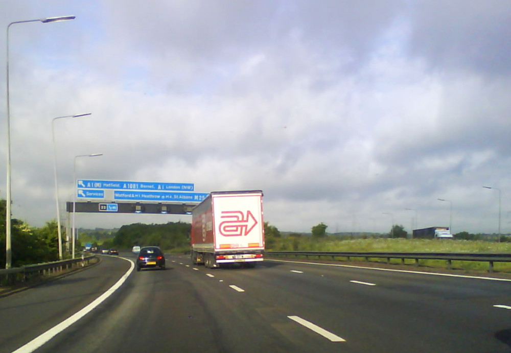
The gap was supposed to be for a junction where the mainline of Ringway 3 would branch off south-west towards the M1. Even as it was being built, it was already known that the gap would now never be used. But it still had to be there, because those were the plans that had been approved, and it was far too late to change them.
This all means that the motorway encloses a huge area of land for no specific purpose, isolating and sterilising it for all time in the name of a motorway project that was dead even before the M25 was laid out.
It's not a small area, either: by our measurements, there's 68,421 m² of open land fossilised inside the modern M25; that's almost 17 acres. If you find that a difficult size to visualise, it's the size of 13 football pitches, enough room to build fourteen Empire State Buildings, or just enough space to squeeze in a tenth of Disneyland.
More than that, though, it's a visible monument to a very sudden u-turn in planning policy, and a section of Ringway 3 that came very close indeed to being built.
Picture credits
- Route map contains OS data © Crown copyright and database rights (2017) used under the terms of the Open Government Licence.
- Photograph of Holmesdale Tunnel taken from an original by Christine Matthews and used under this Creative Commons licence.
- Photograph of M25 at Potters Bar taken from an original by John Reeves and used under this Creative Commons licence.
- Plan of Theydon Interchange extracted from T 319/2655.
- Paperwork showing "Ringway 3" correction extracted from MT 106/398.
- Map extracts showing M16 and A1178 at Potters Bar are from OS Landranger 166 1974 revision A_* and 1978 revision A and used under fair dealing rules for research and teaching purposes.
- Plan showing Ringway 3 between M1 and A1 extracted from MT 120/273.
- Photograph of gap between M25 carriageways taken from an original by MrEd and used with permission.
Sources
- Allocation of number M16: references in T 319/2655 and MT 120/316/1; also appears in many contemporary maps.
- First section opened as A1178: press release in MT 120/316/1 indicates A1-A10 length as "Ringway 3 A1178".
- Bushey Interchange, features on ground consistent with interchange designed by Brandt and O'Dell: MT 120/284/2.
- Route, M1-A1: outline plans sufficient to fix line at MT 120/273.
- Route, A1-Navestock; interchange layouts at A11 and M11: T 319/2655.
- Interchange layout at South Mimms; debate between MOT and GLC about standard of road; agreement to reclassify as motorway after opening: MT 106/398.
- Decision to build only M3-A11 length of R3: MT 106/117.
- Trunk road number and name proposals; A1-A10 length programmed for 1962-3: MT 106/108.
- Difficulty cancelling M1-A1 length: MT 120/314.
_-_Coppermine_-_22446.jpg)