For the last couple of years we've been steadily publishing our updated pages on London's unbuilt urban motorway network. Today it's the turn of the outermost ring road, Ringway 4.
Roads.org.uk is home to a research project that's been ongoing for 15 years to uncover the history and the plans for the Ringways, a network of largely unbuilt urban motorways that would have changed everything about the capital. It's a remarkable story, one that's still largely forgotten even by most popular histories of London, and we're proud to be piecing it together.
Two years ago we took all our Ringways pages offline because they had fallen so far behind the research. Now, the latest set of revised and rewritten pages are back online, telling the story of Ringway 4. And this one is a bit of an oddity.
This is the fourth and final of the three ring roads planned for London. Yes, that's right - the fourth of three. The Ringways, you see, were numbered 1, 2 and 3; beyond the boundaries of London a fourth ring was planned that was never officially part of the Ringways project but which would inevitably have complemented it by creating another orbital route. We call it Ringway 4 for convenience, even though there's little evidence that anyone in Government circles ever used that name. They would have known it as two separate projects, the North and South Orbital Roads.

If you look for it today, you'll find that two thirds of it were built, and now form the UK's busiest section of motorway. The remaining third, in contrast, would have carried so little traffic that its construction could never be justified.
What's new?
If you remember anything about our old Ringway 4 pages you'll recall how short they were. Detailed research, when they were first written, was thin on the ground. Thankfully that's all changed. There's now a wealth of new material to draw on, and the new pages are stuffed with previously-unknown information and curious stories. The difficult part this time has been figuring out how to shoehorn in all the complexity of all the ever-shifting plans.
Like all the other pages in our Ringways section, the new pages have been brought right up to date with:
- Vast amounts of new information, new illustrations, and completely rewritten text.
- Detailed maps of each road complete with junction layouts. The maps are overlaid on modern Ordnance Survey mapping so the plans can be compared with the M25 and other roads as eventually built.
- Full lists of source material and picture sources.
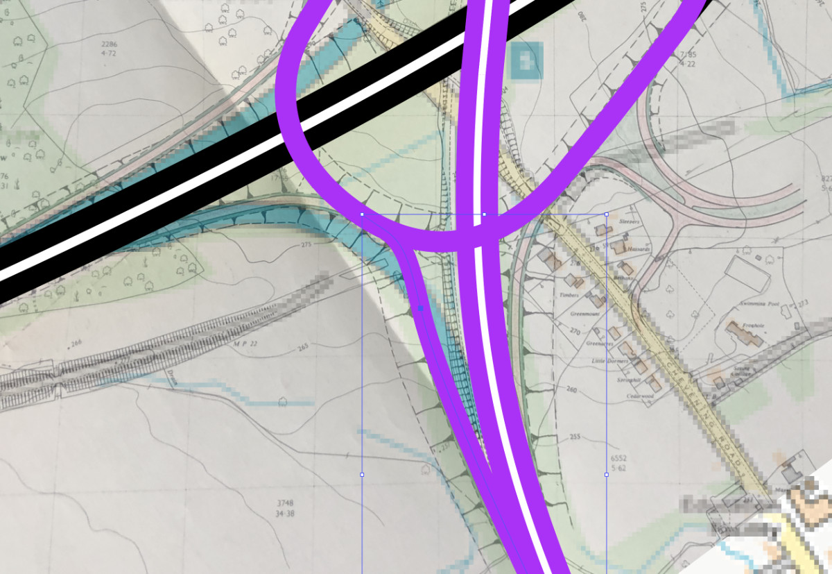
We occasionally get asked about the route maps on the Ringways pages. They are as accurate as we can possibly make them: everything is drawn from period maps or plan-accurate diagrams, except in a few places where a different symbol indicates an approximation, and in many places the junction layouts are actually plotted by tracing over engineering drawings. The example below shows the layout for Chevening Interchange, now M25 J5, being drawn in over a georeferenced engineering plan of the junction from 1967.
Right now that detailed mapping is available only as a series of individual route maps on each of the Ringways pages, but ultimately the intention is that you'll be able to see the whole map of London, and be able to scroll around and zoom in and out, as one of the layers on the brilliant SABRE Maps. That will have to wait, though, until the whole thing is finished.
What's next?
These pages complete the full set of Ringways - all four are now online, along with the pages outlining the history of the whole project. But, of course, that doesn't complete the full urban motorway network.
Plenty more pages are yet to be published, and those are the radial routes, which will arrive in three groups. The first will be the northern radials, covering everything from the M1 to the M13. They should appear online early in 2020.
Right now, though, please enjoy the history of Ringway 4, the Ringway that isn't a Ringway.
Elsewhere on
Roads.org.uk...

Ringways
The story of an incredible plan to reshape London into a city of motorways, with the history from creation to cancellation and details on every unbuilt road.
![]()
Comments
Add new comment
Picture credits
- Interchange diagram extracted from MT 120/249.
- Map extract contains OS data © Crown copyright and database rights (2017) used under the terms of the Open Government Licence.

Fascinating stuff! The western and northern sections of Ringway 4 are an extraordinary story of earlier attempts to build an orbital being bypassed by newer versions. If the A405 Rickmansworth bypass had been built in the 50s as a lower standard D2 road, then would this route from the A40 northwards been upgraded to Motorway in the 70s or would the NW section of Ringway 3 been built instead?